Environmental Protection
Department
Agreement No. CE20/2004 (EP)
North East New Territories (NENT) Landfill
Extension
Environmental Impact Assessment Report
May 2007
Contents
1.2
Purpose and Scope of the EIA Study
1.5
Structure of the EIA Report
2.1
General Description of the Project
2.4
Consideration of Alternatives
2.5
Site Location and Site History
2.6
Nature, Scope and Benefits of the Project
2.7
Size, Scale, Shape and Design of the Project
3.2
Environmental Legislation, Standards and Guideline
3.3
Description of the Existing NENT Landfill and the Extension
3.5
Identification of Air Pollution Source and Environmental Impact
3.7
Prediction and Evaluation of Air Quality Impact
3.9
Residual Environmental Impact
3.10
Implication of IWMF Implementation
4.2
Environmental Legislation, Standards and Guidelines
4.3
Description of the Environment
4.6
Construction, Restoration & Aftercare Noise Impact Assessment
4.7
Operational Noise Impact Assessment
4.8
Residual Environmental Impact
5.2
Environmental Legislation, Standards and Guidelines
5.6
Identification and Evaluation of Water Quality Impacts
6
Waste Management Implications
6.2
Legislation, Standards and Guidelines
6.4
Identification and Evaluation of Waste Management Implications
6.8
Implication of IWMF Implementation
7.2
Legislation, Standards and Guidelines
7.5
Protective and Precautionary Measures
7.7
Implication of IWMF Implementation
8.2
Legislation, Standards and Guidelines
8.3
Landscape And Visual Impact Assessment Methodology
8.5
Planning and Development Control Review
8.6
Source of Impacts and Impact Assessment
9.2
Environmental Legislation & Standards
9.3
Description of the Study Area
9.6
Identification and Evaluation of Impacts
9.7
Mitigation
Recommendations
10.2
Relevant Legislation and Guidelines
10.3
Field Survey Scope and Methodology
10.5
Results of Literature Review
10.7
Evaluation of Habitats and Species
10.8
Impact Identification and Evaluation
10.9
Impact Avoidance and Mitigation Measures
10.10
Residual Ecological Impacts
10.11
Ecological Monitoring and Audits
11
Summary of Environmental Outcome
11.1
Population and Environmental Sensitive Areas Protected
11.2
Environmental Friendly Design and Benefit
11.3
Key Environmental Problem Avoided
11.4
Environmental Protection Measures and Precautionary Measures
12
Environmental Monitoring and Audit Requirements
12.3
EM&A Manual and Implementation Schedule
14.7
Landscape and Visual Impact
14.10
Environmental Monitoring and Audit
24315/01/005
Existing NENT Landfill and Proposed Landfill Extension
24315/01/101
Landfill Extension Layout Option 1
24315/01/102
Landfill Extension Layout Option 1a
24315/01/103
Landfill Extension Layout Option 1b
24315/01/104
Landfill Extension Layout Option 2
24315/01/105
Landfill Extension Layout Option 2a
24315/01/106
Landfill Extension Layout Option 3
24315/01/107
Landfill Extension Layout Option 4
24315/13/101
Location of Air Sensitive Receivers (Assessment Points)
24315/13/103
NO2, SO2 & VOC Emission Source
Location
24315/13/104
Odour Emission Source Location
24315/13/105
Predicted 1-hour TSP Contour (mg/m³) at 1.5m Above Ground (Worst-case
Scenario)
24315/13/106
Predicted 24-hour TSP Contour (mg/m³) at 1.5m Above Ground (Worst-case
Scenario)
24315/13/113
Predicted 5-second Averaged Odour Contour
at 1.5m Above Ground (Northern Tipping)
24315/13/114
Predicted 5-second Averaged Odour Contour
at 1.5m Above Ground (Western Tipping)
24315/13/201
Location of Noise Sensitive Receivers
24315/13/202
Proposed Planter Wall at Wo Keng Shan Road
24315/13/203
Location of Fixed Noise Sources
24315/13/301
Location of Groundwater Monitoring Point for Existing NENT Landfill
24315/13/302
Boreholes Location Plan
24315/13/304
Catchment Areas near the NENT Landfill Extension Site
24315/13/501
Geological Map of NENT Landfill Extension Site
24315/13/502
LFG Consultation Zone
24315/13/503
Monitoring of Background CO2
Levels at 25 Boreholes
24315/13/504
Existing Landfill and Landfill Extension Monitoring Plan
24315/14/001
NENT Landfill Extension & Source of Impact
24315/14/002
Landscape Character Areas (LCAs) Plan & Impact Assessment (Without
Mitigation)
24315/14/003
Aerial Photograph of the Project Site and the Surroundings
24315/14/004
Landscape Resources (LRS) Plan & Impact Assessment (Without Mitigation)
24315/14/007
Typical View of Visual Sensitive Receivers to Proposed Development (Sheet 1 of
2)
24315/14/008
Typical View of Visual Sensitive Receivers to Proposed Development (Sheet 2 of
2)
24315/14/010
Photo Montage of Selected View (Sheet 1 of 3)
24315/14/011
Photo Montage of Selected View (Sheet 2 of 3)
24315/14/012
Photo Montage of Selected View (Sheet 3 of 3)
24315/13/602
Study Area of Option 4 (Divided into Four Sub-sections for Ease of Reference)
24315/13/603
Solid and Superficial Geology (Sheung Shui) Hong Kong Geological Survey
24315/13/604
Location of Auger Holes and Test Pits
24315/13/605
Contexts of Test Pits
24315/13/606
Archaeological Findings
24315/13/701 Location of Site of Conservation Importance and Sampling Transects and Points for Fauna
24315/13/702
Habitat Map Location of Species of Conservation interest overlaid with Option 4
24315/13/703
Photos of Habitat and Species of Conservation interest
Appendices
Appendix
2.1 EIA Study Brief ESB-114/2004
Appendix
2.2 Tentative Outline Programme
Appendix
3.1 Construction Dust Assessment
Appendix
3.2 Gaseous Emission Assessment
Appendix
3.3A Identification of Worst Weather Condition for Odour
Assessment
Appendix
3.3 Odour Emission Assessment
Appendix
3.4 Odour Emission Strength and Modelling
Parameters
Appendix
3.5 Surface Roughness Calculation in the area
Appendix 3.6 Odour Hourly Emission
Concentration
Appendix
3.7 Predicted 1-hour and 24-hour TSP
concentration
Appendix
3.10 Predicted odour concentration
Appendix
4.1 Sound Power Level of PMEs
Appendix
4.2 Construction Plant Inventory
Appendix
4.3 Locations of Notional Sources and Distance to
NSRs
Appendix
4.4 Detail Calculation of Construction Noise
Assessment
Appendix
4.5 Detail Calculation of Cumulative Construction
Noise Assessment
Appendix
4.6 Compute Plot of Road Traffic Noise Model
Appendix
4.7 Noise Measurement Results of Aeration Lagoon
Appendix
4.8 Noise Measurement Results of Ammonia
Stripping Plant
Appendix 4.9
Noise Measurement Results of Refuse Vehicle
Appendix
4.10 Detail Calculation of On-site Operation Noise
(Un-mitigated Scenario)
Appendix
4.11 Detail Calculation of On-site Operation Noise
(Mitigated Scenario)
Appendix
4.12 Detail Calculation of Existing Landfill
Operational Noise
Appendix
5.1 Groundwater Monitoring Data for Existing NENT
Landfill from January 2005 to March 2006
Appendix
5.2 Leachate Generated from Landfill
Appendix
7.1 LFG Protection Measures in Existing NENT
Landfill
Appendix
7.2 Specific LFG Protection Measures for Building
Services
Appendix
9.3 Cultural Landscape Feature Recording Form
Appendix
9.4 Methodology for Preservation by Record
Appendix
10.1 Freshwater Fish known to be present in Lin Ma Hang
Stream
Appendix
10.2 Bat species recorded in Ling Ma Hang or in the
vicinity of the Study Area
Appendix
10.3 Plant species recorded within the Study Area
Appendix
10.4 Bird species and their abundance in the Project
Area
Appendix
10.5 Bird species and their abundance in the Study Area
Appendix
10.6 Dragonfly species and their abundance in the
Project Area
Appendix
10.7 Butterfly species and their abundance in the
Project Area
Appendix
10.8 Dragonfly species and their abundance in the Study
Area
Appendix
10.9 Butterfly species and their abundance in the Study
Area
Abbreviation
|
ASR |
Air Sensitive Receiver |
|
BMP |
Best Management Practice |
|
BOD5 |
5-Day Biochemical Oxygen Demand |
|
COD |
Chemical Oxygen Demand |
|
CRTN |
Calculation of Road Traffic Noise |
|
DIA |
Drainage Impact Assessment |
|
DO |
Dissolved Oxygen |
|
DP |
Designated Project |
|
EIA |
Environmental Impact Assessment |
|
EIAO |
Environmental Impact Assessment Ordinance |
|
EPD |
Environmental Protection Department |
|
ETWBTC |
Environment, Transport and Works Bureau Technical Circular |
|
GCL |
Geosynthetic clay liner |
|
HDPE |
High density polyethylene |
|
HKPSG |
|
|
IWMF |
Integrated Waste Management Facilities |
|
MSW |
Municipal solid waste |
|
NCO |
Noise Control Ordinance |
|
NENT |
North East New Territories |
|
NSR |
Noise Sensitive Receiver |
|
OZP |
Outline Zoning Plan |
|
PCB |
Polychlorinated Biphenyl |
|
ProPECC |
Environmental Protection Department Practice Note for Professional Persons |
|
SBA |
Stockpile and Borrow Area |
|
SBR |
Sequencing Batch Reactor |
|
SENT |
South East New Territories |
|
SPL |
Sound Pressure Levels |
|
SS |
Suspended Solid |
|
SWHSTW |
Shek Wu Hui Sewage Treatment Works |
|
SWL |
Sound Power Levels |
|
TKN |
Total Kjeldahl Nitrogen |
|
TM-EIAO |
Technical Memorandum on Environmental Impact Assessment Process (Environmental Impact Assessment Ordinance, Cap. 499, S.16) |
|
TM-Places |
TM for the Assessment of Noise from Places other than Domestic Premises, Public Places or Construction Sites |
|
TM-PP |
Technical Memorandum on Noise from Percussive Piling |
|
TM-DA |
Technical Memorandum on Noise from Construction Work in Designated Areas |
|
TM-GW |
Technical Memorandum on Noise from Construction Work other than Percussive Piling |
|
TM-Water |
Technical Memorandum on Standards for Effluent Discharged into Drainage and Sewerage System, Inland and Coastal Waters |
|
TN |
Total Nitrogen |
|
TOC |
Total Organic Carbon |
|
TSS |
Total Suspended Solid |
|
TTSAS |
Tong To Shan Archaeological Site |
|
USEPA |
United State Environmental Protection Agency |
|
WCZ |
Water Control Zone |
|
WENT |
West New Territories |
|
WHO |
World Health Organization |
|
WPCO |
Water Pollution Control Ordinance |
|
WRFP |
Waste Reduction Framework Plan |
|
WSR |
Water Sensitive Receiver |
|
WQI |
Water Quality Indexes |
|
WQO |
Water Quality Objective |
|
|
|
|
|
|
|
|
|
|
|
|
|
|
|
|
|
|
|
|
|
|
|
|
|
|
|
Currently,
about 6 million tonnes of waste are disposed each year at the three strategic
landfills in Hong Kong, including the West New Territories (WENT) Landfill, the
South East New Territories (SENT) Landfill, and the North East New Territories
(NENT) Landfill.
At time
of commissioning, the three landfills with a total capacity in the order of
To tackle
the problem, further efforts have been taken to reduce and recycle waste.
Also, the HKSAR Government has planned to develop Integrated Waste Management
Facilities (IWMF) to substantially reduce the volume of waste requiring
landfill disposal. Yet these measures could not obviate totally the need
for new landfill capacity in Hong Kong, especially as the implementation of
IWMF will take time and as its residues will still need to be disposed.
The
Environmental Protection Department (EPD) of the HKSAR Government therefore
commissioned a Study in Year 2000 on the Extension of Existing Landfills and
Identification of Potential New Waste Disposal Sites. Amongst the
potential sites recommended in this territory-wide study is an extension of the
existing NENT Landfill, with a target capacity of about
In February 2005, EPD appointed Ove Arup & Partners Hong Kong Ltd.
to undertake a detailed feasibility study for the NENT Landfill Extension
(hereafter referred to “the Project”), with the following key tasks:
formulation and evaluation of layout options for the landfill extension; EIA
study; and conceptual design of landfill facilities.
The
purpose of this EIA Study is to provide information on the nature and extent of
environmental impacts arising from the construction, operation, restoration and
aftercare stages of the NENT Landfill Extension, and to contribute to decisions
on the overall acceptability of the Project, after the implementation of
environmental mitigation measures.
The NENT
Landfill Extension is a Designated Project under Schedule 2, G.1, of the EIAO :
“A landfill for waste as defined in the Waste Disposal Ordinance (Cap.
354)”. The EIA study, undertaken under the NENT Landfill Extension
Feasibility Study, has therefore been carried out in strict accordance with the
EIAO, including the requirements stipulated in EIA Study Brief No. ESB-114/2004
issued under the EIAO.
Drawing No. 24315/01/001 shows
the location of the Project site.
The EIA
study areas for the impact assessments on air quality, noise, water quality,
landfill gas, ecology, landscape & visual and cultural heritage as defined
in accordance with the requirements in the EIA Study Brief and are presented in
Table 1.1 below.
Table 1.1: Study areas for various assessments
|
Aspect |
Study Area |
Remarks |
|
Air Quality |
within
|
According
to the study brief requirements with additional ASRs selected between 500 to |
|
Noise |
within
|
According
to the study brief requirements with additional NSRs selected between 300 to |
|
Water Quality and Aquatic Ecology |
within
|
According to the study brief requirements, with additional WSRs such as nearby watercourses, the associated water systems and the coastal water of Deep Bay and Starling Inlet. |
|
Landfill gas |
within |
According to the study brief requirements |
|
Landscape |
within |
According to the study brief requirements |
|
Visual |
visual envelope |
According to the study brief requirements |
|
Cultural Heritage |
within |
According to the study brief requirements |
|
Terrestrial Ecology |
within |
According to the study brief requirements. |
The EIA
study has been prepared in accordance with the guidelines provided in Annex 11
of the TM-EIAO for the report contents and Annexes 12 to 19 for the impact
assessments of various environmental issues. The general approaches and
methodologies adopted for this EIA study are described below.
The
characteristics of the existing environment were reviewed for identification
and prediction of environmental impacts. Baseline surveys were conducted to
determine the existing environmental conditions on the Project site and in any
environs likely to be affected by the Project. The baseline conditions of the
key issues as identified in the EIA Study Brief including air quality, noise,
water quality, landscape & visual, cultural heritage and ecology are
described in the assessment.
The EIA
Study was undertaken in accordance with the guidelines on assessment methodologies
given in Annexes 12 to 19 of the TM-EIAO. Quantitative predicting tools were
employed for assessing the environmental impacts in respect of construction
dust, operational air quality, construction noise, operational noise and water
quality. The predictions were conducted based on well-recognized methods such
as Arup plant noise impact analysis for construction activities, CRTN for
evaluating operational road traffic noise impact, ISCST3 for evaluating
fugitive and odorous source impacts, and hydrogeological model for evaluating
the change of groundwater flow regime.
The
applied methodologies for the Project had previously been adopted in other EIA
studies. They have been generally accepted for use in predicting environmental
impacts and for comparison of assessment results with the TM-EIAO requirements.
Limitations are however envisaged of these methodologies. The accuracy of the
prediction result will be affected by the degree of uncertainty in input data
such as construction plant, air emission inventories and predicted traffic
flow. Quantitative uncertainties in the prediction have been considered when
drawing conclusion from the assessment results. In carrying out the prediction,
realistic worst-case assumptions have been made in order to provide a
conservative assessment of environmental impacts.
The
predicted changes and effects as a result of the Project were evaluated with
respect to the criteria described in Annexes 4 to 10 of the TM-EIAO, and were
in quantitative terms as far as practicable.
Mitigation
measures have been identified and evaluated to avoid, minimize or remedy the
impacts. Priority was given to avoidance of impacts as a primary means of
mitigation. The effectiveness of mitigation measures was assessed and the
residual environmental impacts identified. Evaluation of impact was made with
respect to the criteria described in Annexes 4 to 10 of the TM-EIAO, in
quantitative terms as far as practicable.
The
structure of this EIA Report is outlined below for ease of reference:
|
Chapter |
Title |
Aims |
|
1 |
Introduction |
To provide project background, purpose and scope of the EIA Study and to define the EIA study area. |
|
2 |
Description of the Project |
To describe the project requirements, consideration of alternative and major activities in the Project. |
|
3 |
Air Quality Impact |
To assess the potential air quality impact of the Project and suggest mitigation measures. |
|
4 |
Noise Impact |
To assess the potential noise impact of the Project and suggest mitigation measures. |
|
5 |
Water Quality Impact |
To assess the potential water quality impact of the Project and suggest mitigation measures. |
|
6 |
Waste Management Implications |
To assess the potential waste management implications of the Project and suggest mitigation measures. |
|
7 |
Landfill Gas Hazards |
To assess the potential hazards arising from landfill gas migration and suggest precautionary measures. |
|
8 |
Landscape and Visual Impact |
To assess the potential landscape and visual impacts of the Project and suggest mitigation measures. |
|
9 |
Impact on Cultural Heritage |
To assess the potential impacts of the Project on cultural heritage and suggest mitigation measures. |
|
10 |
Ecological Impact |
To assess the potential ecological impacts of the Project and suggest mitigation measures. |
|
11 |
Summary of Environmental Outcome |
To summarise the key environmental outcomes arising from the EIA Study. |
|
12 |
Environmental Monitoring and Audit Requirements |
To define the scope of the EM&A requirements for the Project. |
|
13 |
3-Dimensional EIA |
To describe the 3-Dimensional EIA for this Study. |
|
14 |
Conclusion |
To conclude the assessment results of the EIA Study. |
The
development of the NENT Landfill Extension (hereafter referred to “the
Project”) will involve the following works:
· Site
formation and preparation.
· Installation
of liner system.
· Installation
of leachate collection, treatment and disposal facilities.
· Installation
of gas collection, utilization and management facilities.
· Utilities
provisions and drainage diversion.
· Operation
of landfill.
· Restoration
and aftercare in subsequent stages.
· Measures
to mitigate environmental impacts as well as environmental monitoring and
auditing to be implemented.
The key
project requirements for the NENT Landfill Extension are:
· Development
of a sanitary landfill that covers an area of about
· Provision
of a liner system for the landfill to prevent contamination of land and water
resources;
· Provision
of a leachate collection, treatment and disposal facilities with sufficient
capacity for handling the leachate arising from the landfill extension;
· Provision
of landfill gas collection, utilisation and management facilities;
· Provision
of utilities, drainage and road network necessary for the proper operation of
the Project;
· Provision
of facilities (both civil works and electrical & mechanical equipment) for
waste reception, inspection, charging, handling and compaction, and plant
maintenance;
· Provision
of facilities for site administration;
· Operation
of the landfill in compliance with all relevant engineering, geotechnical and
environmental standards;
· Restoration
of the landfill in compliance with all relevant engineering, geotechnical and
environmental standards;
· Provision
of aftercare for the landfill for a period of about 30 years;
· Carrying
out environmental monitoring and audits throughout construction, operation,
restoration and aftercare of the landfill; and
· Implementation
of environmental measures necessary for the protection of the surrounding
environment.
Waste is
a common problem of affluent societies. Especially when people can afford
greater convenience and more purchases, they tend to generate a higher volume
of waste per capita. Hong Kong is no exception to this. Like many other modern
cities, Hong Kong has seen its wasteloads increase following the economic
growth. Municipal wasteloads have grown on average of about 3% per year
since 1986. With the population growth at 0.9% each year, the waste
generation rate has risen from
|
|
|
|
|
|
|
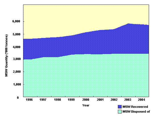
Figure 2.1 Waste line grew from 1996 to
2004 [extracted from EPD” Policy Framework for the Management of MSW
(2005-2014)”]
Hong Kong’s waste
arising have exceeded the expected amount. At the time when the three existing
strategic landfills, SENT Landfill, NENT Landfill and WENT Landfill, were
planned, it was forecasted that the daily amount of waste to be disposed of at
landfills would rise from 12,500 tonnes in 1989, to 14,000 tonnes in 1997 and
16,700 tonnes by 2001. By 1997 the three strategic landfills were already
taking in 16,000 tonnes of waste every day. Should this trend continue, the
landfills will be full by 2015, instead of lasting until 2020 as they were
originally designed for.
Although
all measures outlined in the Policy Framework for the Management of Municipal
Solid Waste (2005-2014) including source separation, MSW charging, waste
recycling, IWMF, etc. would help extend the lives of the three landfills, the
residues from the IWMF will still require sites for final disposal and landfill
site is therefore necessary.
The
reality is that HK, like all other developed cities around the world, will need
landfills as the final means of disposal. Assuming the Government’s
target of reducing the waste going to landfill site from 60% in 2004 to 25% by
2014 will be achieved, some 4000 tonnes per day of waste still needs to be
disposed of at landfill sites. Therefore, outlets for landfill sites for final
disposal of solid waste are still required. Extensions of existing
landfill sites have been identified as an indispensable element for the
management of waste in Hong Kong. Justifications of the need for
providing additional void space for waste disposal by developing extension at
the existing NENT Landfill are provided in the following sections.
With a clear Government strategy to achieve
sustainable management of the MSW in the next 10 years, it is anticipated that
the amount of solid waste requiring landfill disposal will start to reduce
gradually. Having said that, there will still be millions of tonnes of
un-recyclable or unrecoverable waste requiring disposal each year. With the
three existing strategic landfills envisaged to be exhausted between Year 2011
to 2015 and the long lead time required for developing new landfills, there is
a need to identify an intermediate solution.
EPD had
therefore commissioned a study in February 2000 to explore the potential of
extending the existing landfills and identify potential new landfill sites.
Given
that it will take many years to confirm suitability of a new landfill location,
extensions of the existing landfills were considered a practicable, necessary
and urgent intermediate solution. Key advantages of the extension schemes
include:
·
Availability of existing supporting infrastructure and therefore less
lead time for the development.
·
Availability of existing supporting infrastructure and therefore more
cost effective for the development.
·
Availability of accurate information and hence lower level of risk in
capital and operating costs estimation.
·
Availability of existing environmental monitoring data and hence more
reliable for confirming environmental acceptability of the Project.
·
Availability of existing supporting infrastructure and therefore less
requirements on land resumption for the development.
·
Availability of existing supporting infrastructure and therefore
potentially less impact on the environment in comparison with a new green field
site scheme.
·
Established site specific procedures for operation and environmental
impact control.
These
key advantages are recognised at the NENT Landfill for the proposed extension.
The
key issues and constraints identified during the course of study were taken
into account in formulation of landfill extension layout options. A total
of 4 broad options (as well as related sub-options) were thoroughly evaluated
and discussed at a Value Management Workshop on 2 December 2005, attended by
relevant stakeholders. Key features of the various options are recapitulated
below.
Option 1
adopts a similar rationale as the proposed conforming scheme in the EPD’s
preliminary study under “Agreement No. CE45/99, Extension of Existing Landfills
and Identification of Potential Waste Disposal Sites, Final Strategic Environmental
Assessment Report”. It achieves a landfill capacity of
Table 2.1: Summary of Option 1
|
Waste receiving area |
|
|
Maximum fill level |
+245 mPD |
|
Site formation complexity |
Cut
volume |
|
Landfill capacity |
|
Option
Table 2.2: Summary of Option
|
Waste receiving area |
|
|
Maximum fill level |
+255 mPD |
|
Site formation complexity |
Cut volume |
|
Landfill capacity |
|
Option 1b is derived based on Options 1 and
Table 2.3: Summary of Option 1b
|
Waste receiving area |
|
|
Maximum fill level |
+300 mPD |
|
Site formation complexity |
Cut
volume |
|
Landfill capacity |
|
Option 2 avoids the encroachment on TTSAS
and keeps the peak level the same as Option 1 (i.e. +245mPD). This will
reduce the actual landfill capacity to
Table 2.4: Summary of Option 2
|
Waste receiving area |
|
|
Maximum fill level |
+245 mPD |
|
Site formation complexity |
Cut
volume |
|
Landfill capacity |
|
Similar to Option 2, Option
Table 2.5: Summary of Option
|
Waste receiving area |
|
|
Maximum fill level |
+255 mPD |
|
Site formation complexity |
Cut
volume |
|
Landfill capacity |
|
Archaeological survey conducted on the site
has identified a number of large graves in the heart of the landfill extension.
Option 3 is developed with extensive reinforced earth wall at the northern
boundary to avoid the need for clearance of these existing large graves (Drawing No. 24315/01/106). The landfill capacity will however be
reduced to only
Table 2.6: Summary of Option 3
|
Waste receiving area |
|
|
Maximum fill level |
+245 mPD |
|
Site formation complexity |
Cut
volume |
|
Landfill capacity |
|
Option 4 is developed with the northwestern
and southeastern boundary extended to reach the ridgeline to maximize the
landfill capacity. The northern boundary is also set back to minimize the
impact to woodland as well as TTSAS (see Drawing No. 24315/01/107). The landfill capacity can achieve
Table 2.7: Summary of Option 4
|
Waste receiving area |
|
|
Maximum fill level |
+255 mPD |
|
Site formation complexity |
Cut
volume |
|
Landfill capacity |
|
These
options were evaluated / assessed in accordance with the following factors and
main criteria :
· Waste
management needs of
· Engineering
considerations including site formation complexity, constructability, drainage
impact and maintenance;
· Environmental
issues such as noise, air quality, ecology, landscape and visual, waste
management, cultural heritage, water quality, etc.
· Social
issues such as afteruse flexibility, cost of disposal, land resumption and
graves clearance.
Under the previous study ”Agreement
No. CE45/99, Extension of Existing Landfills and Identification of Potential
Waste Disposal Sites, Final Strategic Environmental Assessment Report”, the “Strategic Plan” for the development of
NENT Landfill Extension required a void space (landfill capacity) of
The major engineering considerations relate
to construction practicability, drainage impact to downstream rivers and
requirements on operation and maintenance of the various facilities are
discussed as follows:
Construction
Practicability
The optimum engineering design of a landfill
site is to maintain a balance in cut and fill material over the entire
construction and operation periods. Importing or exporting construction
material is not preferred. In this regard, all the four broad options including sub-options can
achieve this requirement.
According to the
recent ground investigation (GI) data, there is no particular geological
constraint in the proposed landfill extension site. Site formation and
retaining structures for all options are feasible to construct. All options
will experience the same founding condition and reinforced fill slopes will be
adopted for retaining structures taller than
Although Options 1,
Drainage
Impact to Downstream
All
options affect the existing landform and may have impact to the adjacent
drainage systems at both Lin Ma Hang Stream and Ping Yuen River.
According to the
Drainage Impact Assessment (DIA) conducted for this Project, the diversion of
catchment in some options will result in increased water level in Ping Yuen
River and decreased water level in Lin Ma Hang Stream. In other words, the less
the impact on stream and river, the more preferable the option.
Options 2,
Operation
and Maintenance
The
operation and maintenance requirements for various facilities such as treatment
facilities, drainage system, E&M equipment, water quality, leachate and
landfill gas monitoring equipment, etc. are similar for all the 4 options.
Option 1,
The major environmental considerations relate
to water quality, ecology, archaeology and cultural heritage, landscape and
visual etc. at various project phases are discussed as follows:
Water Quality Impact
Some
of the landfill extension options may encroach to both Lin Ma Hang and Ping
Yuen Catchments. There may be certain degree of influence of water
flow/yield on Lin Ma Hang Stream and Ping Yuen River. In case of any
accidental overflow from the treatment plant or accidental leakage through the
liner, there might be short-term impact on the adjacent streams.
Options 2,
Ecological
Impact
Some
of the landfill extension options may cause minor ecological impacts to the Lin
Ma Hang Stream due to reduction in water level and loss of woodland and
shrubland. Option 1,
Woodland of over
With consideration of a cumulative
combination of ecological impacts (drop in water level and loss in woodland),
Options 1,
Archaeological
and heritage Impact
Some of the landfill extension options may
encroach into TTSAS affecting secondary features such as boulder paths and
boulder terraces. A total of 21 graves including 10 old graves will be
affected and will need to be removed. In terms of impacts to graves, all
options have the same grade as these can be mitigated by detailed preservation
by record as agreed with AMO, LCSD.
Option 1,
Options 2,
Landscape
and Visual Impact
Option
Option
Option 3 will have a total area of about
Option 4 will have a total area of about
In fact, the visual impact to the adjacent
areas for all options is similar with slight impact (also see Chapter 8).
Other
environmental considerations
Other environmental considerations, including
air, noise, waste, landfill gas, have been reviewed. The potential
impacts for all options are similar in order and can all be mitigated by
suitable mitigation measures.
The major community considerations relate to flexibility
for aftercare, unit cost per disposal, needs for land resumption and needs for
graves clearance at various project phases are discussed as follows:
Flexibility for
Afteruse
The
proposed extension is expected to last for about 10 to 12 years. Options
that can offer higher flexibility to the potential afteruse of the landfill are
preferred.
Options 1,
Option 2 and
Similarly, Option 3 has the smallest
landfill area of only
Unit Cost
per Disposal
The
unit cost per disposal is the capital cost divided by the actual landfill
capacity, which is the cost required to produce a
The anticipated unit
cost per disposal (m³) for Options 1,
Needs for
Land Resumption
All
Options will affect the same number of private lots. Nonetheless,
Option 1,
Needs for Graves
Clearance
According to recent survey, there are a
large number of graves including some old graves lying within the extension
site. All options affect almost the same number of graves including old
graves except for Option 3 which affect a much smaller number of graves (9
to 10 graves less). Option 3 is therefore preferred. All other
options are less preferable since a longer lead time would be required on
liaison in the graves clearance process.
Amongst the three options in Broad Layout
Option 1, Option
Table 2.8:
Summary of reasons for option evaluation
|
Criteria |
Option |
Option |
Option 3 |
Option 4 |
|
(A) Waste Management Needs |
(Preferred) |
(Less Preferred)
|
(Less Preferred) |
(Preferred) |
|
(B) Engineering |
||||
|
Construction Practicability |
No imported fill material is required for the site formation works; Require short ( (Preferred) |
No imported fill material is required for the site formation works; Require relatively long ( (Preferred) |
No imported fill material is required for the site formation works; Require relatively long reinforced earth wall (with max. height of (Less Preferred)
|
No imported fill material is required for the site formation works; Require relatively long reinforced earth wall (with max. height of (Preferred) |
|
Drainage Impact to Downstream |
Impact to both Lin Ma Hang Stream and Ping Yuen River. (Less Preferred) |
Impact to Ping Yuen River (no impact on Lin Ma Hang). (Preferred) |
Impact to Ping Yuen River (no impact on Lin Ma Hang). (Preferred) |
Impact to Ping Yuen River (no impact on Lin Ma Hang). (Preferred)
|
|
Operation and Maintenance |
Require maintenance of a
short reinforced earth wall and associated drainage system ( (Preferred) |
Require maintenance of a
relatively long reinforced earth wall and associated drainage system ( (Less Preferred) |
Require maintenance of a
relatively long reinforced earth wall and associated drainage system ( (Less Preferred) |
Require maintenance
of a relatively long reinforced earth wall and associated drainage
system ( (Less Preferred) |
|
(C) Environmental |
||||
|
Water Quality Impact |
Impact to both Lin Ma Hang Stream and Ping Yuen River (Less Preferred) |
Impact to Ping Yuen River (no impact on Lin Ma Hang) (Preferred) |
Impact to Ping Yuen River (no impact on Lin Ma Hang) (Preferred)
|
Impact to Ping Yuen River (no impact on Lin Ma Hang) (Preferred) |
|
Ecology Impacts |
Minor impact to the Lin Ma Hang Stream & its catchment; Relatively large scale of woodland loss ( No impact to Lin Ma Hang Lead Mines; Minor impact to the Robin’s Nest countryside; (Less Preferred) |
No impact to the Lin Ma Hang Stream & its catchment; Small scale of woodland loss ( No impact to Lin Ma Hang Lead Mines; Minor impact to the Robin’s Nest countryside; (Preferred)
|
No impact to the Lin Ma Hang Stream & its catchment; Small scale of woodland loss ( No impact to Lin Ma Hang Lead Mines; Minor impact to the Robin’s Nest countryside; (Preferred) |
No impact to the Lin Ma Hang Stream & its catchment; Medium scale of woodland loss ( No impact to Lin Ma Hang Lead Mines; Minor impact to the Robin’s Nest countryside; (Less Preferred) |
|
Archaeological and Heritage Impact |
Encroach into small (non-core) portion of TTSAS ( Affect 21 graves including 10 old graves (no impact on cultural heritage value). (Less Preferred) |
No impact to TTSAS. Affect 20 graves including 9 old graves (no impact on cultural heritage value). (Preferred) |
No impact to TTSAS. Affect only 9 graves and avoid all old graves (no impact on cultural heritage value). (Preferred) |
Encroach into very small (non-core) portion of TTSAS ( Affect 20 graves including 9 old graves (no impact on cultural heritage value). (Preferred) |
|
Landscape & Visual |
Total landfill area is (Insignificant landscape & visual impact) |
Total landfill area is (Insignificant landscape & visual impact) |
Total landfill area is (Insignificant landscape & visual impact) |
Total landfill area is (Insignificant landscape & visual impact) |
|
Other Environmental Considerations, such as air, noise, landfill gas, waste |
Neutral to various options – minor impact which can be mitigated by suitable mitigation measures. (similar impact to other options) |
Neutral to various options – minor impact which can be mitigated by suitable mitigation measures. (similar impact to other options) |
Neutral to various options – minor impact which can be mitigated by suitable mitigation measures. (similar impact to other options) |
Neutral to various options – minor impact which can be mitigated by suitable mitigation measures. (similar impact to other options) |
|
(D) Impact on Community |
||||
|
Flexibility for afteruse |
Largest landfill area ( (Preferred) |
Smaller landfill area ( (Less Preferred) |
Smallest landfill area ( (Less Preferred) |
Highest landfill area ( (Preferred) |
|
Unit Cost per Disposal |
Comparable with other options except Option 3. (Preferred) |
Comparable with other options except Option 3. (Preferred) |
Higher disposal cost leading to higher chance of illegal dumping. (Less Preferred) |
Comparable with other options except Option 3. (Preferred) |
|
Need for Land Resumption |
Affect private lands and survey station (Less Preferred) |
Affect only private lands (no impact on survey station) (Preferred) |
Affect only private lands (no impact on survey station) (Preferred) |
Affect only private lands (no impact on survey station) (Preferred) |
|
Need for Graves Clearance |
Affect 21 graves including 10 old graves (no impact on cultural heritage value) (Less Preferred) |
Affect 20 graves including 9 old graves (no impact on cultural heritage value) (Less Preferred) |
Affect 9 graves and aovid all old graves (no impact on cultural heritage value) (Preferred) |
Affect 20 graves including 9 old graves (no impact on cultural heritage value) (Less Preferred) |
As Option 4 was evaluated as a preferred option for
the largest number of aspects, it was selected as the overall most preferred
option. See Drawing No. 24315/01/107 for the layout of
Option 4.
Different
construction methodology and sequences of works were studied, giving careful
consideration on environmental impacts including noise, ecology, archaeology,
etc.
It is
recommended to adopt a balanced cut-and-fill site formation for constructing
the landfill bowl within the existing valley.
The NENT
Landfill Extension will be developed in three phases to allow progressive use
of the overall landfill area. Each phase will be constructed, operated
and restored at a rate dependent on the delivery of waste. Simultaneous
construction, operation and capping activities will therefore occur in different
parts of the site.
During
the construction stage, mobilisation & preparation / establishment will be
carried out by the DBO Contractor. A balance between cut-and-fill
quantities will be adopted to optimise the reuse of excavated materials, i.e.
to minimise import or export of materials. The process involves
temporarily stockpiling of excavated materials on site for use as daily cover
during the operation phase and final capping during the restoration
phase. This will reduce construction materials / waste to be delivered to
public fill bank. Where necessary (to be triggered by EM&A
programme), daily cover and temporary cover will be provided to reduce
potential impact on air and water qualities during the operation phase of the
Project.
Alternative construction methods such as blasting have also been
evaluated but found to be not desirable from an engineering perspective.
The balancing of cut-and-fill limits the usable area of the landfill site and
therefore the amount of stockpiled materials. Blasting will generate a
significantly larger volume of excavated and stockpiled materials, and the
usable area of the landfill site will be much reduced. There is also a
safety concern if blasting is conducted in close proximity to the tipping area,
as refuse collection vehicles and operators might be at risk if the buffer
distance provided is not sufficient.
The
landfill extension site of the selected layout is approximately
On its
south-eastern side, the site is enclosed by a major ridgeline, which runs from
Wo Keng Shan (+297mPD) to Robins Nest (+492mPD). A smaller ridge intersects
this main ridgeline and forms the northern flank of the Project area. This
ridge overlooks To Tong Shan Settlement District and Lin Ma Hang Village. It
reaches an elevation of +205mPD at its western end, just beyond the boundary
between the existing NENT Landfill and the extension site. Two saddles, with
minimum elevations of approximately +120mPD, are located about half way along
this smaller ridge.
The ridge
separating the site from the existing NENT Landfill forms the north-western
boundary of the Project area. This ridge runs from an elevation of +205mPD at
its northern end to a level of +65mPD at the point where it intersects the
existing haul road in the south-western corner of the site (Drawing No. 24315/01/001).
The
slopes overlooking the main valley of the site are sparsely vegetated with a
cover of grass and shrubland. Occasional groups of pine trees and localised
dense vegetation are also found along stream courses.
The
proposed extension is mainly covered by the existing NENT Landfill Stockpile
and Borrow Area that was formed to the east of the existing landfill as part of
the original landfill development. The aerial photographs of the site
reveals that several large cut slopes, many of which have been subsequently
covered with stockpiled material, and a haul road (Shek Tsai Ha Road) have been
formed within. The stockpile area is mostly located within the eastern portion
of the site and is bound by concrete drainage channels. Other than the haul
road and scattered gravesites, the remaining site area comprises natural
terrain that has seen little interference from human activity.
The
nature of the Project is to develop a landfill extension for waste as defined
in the Waste Disposal Ordinance (Cap. 354).
The scope
of the Project is to provide a landfill extension of about 70 hectares with a
target void space of at least 19 million cubic metres on the eastern side of
the existing NENT Landfill. On top of site formation and preparation works;
there will be provision of installation of liner system; leachate collection,
treatment and disposal; gas collection and management; utilities provisions;
drainage diversion; restoration and aftercare. Environmental mitigation
measures, monitoring and auditing are provided.
The
development of NENT Landfill Extension ensures the continued provision of final
disposal site for solid waste after the three existing landfills are full by
2015.
It also
avoids illegal dumping of construction waste and municipal waste that may cause
serious environmental problems.
With
waste-to-energy facility (such as Landfill Gas Export Scheme), landfill gas can
be converted to reusable energy that brings benefits to the community.
The
Project site is equipped with waste handling facilities at NENT Landfill, waste
recycling factories in the nearby area, sewage treatment facility at Shek Wu
Hui Sewage Treatment Works, and a landfill gas waste-to-energy facility nearby.
The availability of these existing supporting facilities can shorten the lead
time and land resumption requirement for a new landfill development in a green
field site.
Substantial
saving in cost can also be achieved by pooling together the existing NENT Landfill
infrastructure and facilities by carrying out suitable conversion works under
suitable contractual arrangement.
There are
some small-scale waste recycling factories around the existing NENT Landfill,
skilful workers and special equipments have been allocated in the region.
Therefore, there will be social and economic benefit of the Project, if these
workers and equipments can be tied in with the NENT Landfill Extension (e.g.
sustainable for local employment).
The landfill extension site is a bowl-shape
area with a large void space in the middle for waste filling. The northwestern
and southeastern boundaries of the landfill extension site follow the
ridgelines to maximize the landfill capacity. Some set back of the
northern boundary is included to minimize the impact to woodland and Lin Ma
Hang Catchment. The total site area is about
The key
design features are listed as follows and summarised in Table 2.10:
· Bottom
liner system - to separate rubbish and leachate from groundwater;
· Landfill
cells – to store waste within the unit;
· Storm
water drainage system - to collect rain water run off on the landfill;
· Leachate
collection system - to collect liquid leaching from the waste mass and convey
it to a leachate treatment plant prior to discharging to Shek Wu Hui Sewage
Treatment Works;
· Gas
collection system - to collect gases formed during the decompositon of waste.
These gases will be treated and utilised for production of electricity on site.
· Covering
and capping - to seal off the top of the landfill with a gas venting layer, an
impermeable mineral layer, a drainage layer of at least 0.5 metre and at least
one metre of top soil.
Table 2.10: Summary of key design elements
|
Total size |
|
|
Final height |
+255 mPD |
|
Shape |
Bowl shape at the existing NENT Landfill Stockpile and Borrow Area |
|
Site formation complexity |
Cut
volume |
|
Actual waste capacity |
|
|
Key elements of design |
• Site formation and preparation • Installation of liner system • Installation of leachate collection, treatment and disposal facilities • Installation of gas collection, utilization and management facilities • Utilities provisions and drainage diversion |
Various
activities during construction, operation, restoration and aftercare of
landfill are discussed in the following sub-sections.
Simple
excavation and slope formation works will be carried out during the
construction stage. The permanent works comprise cut and fill earthworks,
slope formation and earth wall construction. The temporary works will
involve the formation of temporary ditches along the sides of the excavations
and associated drainage works, and material storage areas.
During
site formation, sediment will be contained in permanent detention ponds/silt
traps that will be constructed according to landfill phasing. Final design and
location of sediment traps are yet to be decided, but are likely to be down
gradient of each landfill phase or in the downstream valleys near the existing
waste reception area. Where possible they will be maintained during the
operation of each phase to ensure the effective control of operational soil
erosion problem.
During
operation, waste will be disposed of at individual landfill cells.
Deposited waste will be compacted to thin layers. The works will be
maintained at a gradient of not greater than
There are
other more effective alternative biodegradable materials for use as daily
cover. They include:
· heavy
duty reusable and biodegradable sheets;
· non
reusable plastic films;
· geotextiles;
and
· foams and
sprays.
Advantages
of using alternative daily cover over traditional methods include preservation
of landfill capacity and soil material; biodegradable and less permeable to
water and gas (reduce water infiltration, odour and dust emission).
Restoration
is a process to restore a landfill site to a condition suitable for afteruse.
After
completion of waste filling, final capping will be applied to minimise
infiltration of rainwater into the waste body thus reducing the amount of
leachate generated. The capping system normally includes a number of
components including topsoil, subsoil, drainage layer and barrier layer.
Aftercare
is the work done after the replacement of the soil and includes cultivations,
fertilisation, planting, construction of pathways, access points, vegetation
maintenance and monitoring.
Landscaped
berms will be created and tree planting will be provided during the aftercare
period for aesthetic purpose.
The
Landfill Extension will start receiving waste only when the existing NENT
Landfill has ceased operation. The timing of this has yet to be
determined as it depends on the rate of waste deliveries in the forthcoming
period. Based on current prediction, the Existing Landfill will probably
run out by early-to-mid next decade, by which time the Landfill Extension shall
start operation.
Taking
account of the time needed for mobilization and preparatory works prior to
commencement of receipt of waste, it may be necessary to award the Landfill
Extension contract towards the end of this decade, in order to ensure that new
landfill space will be available before the capacity of the existing landfill
runs out.
It is
anticipated that the DBO (Design-Build-Operate) contract form, which has
hitherto worked well for the existing waste management contracts (notably the
three strategic landfill contracts and the refuse transfer station contracts),
will be adopted for NENT Landfill Extension. Detailed design and
formulation of technical details for the construction, operation, restoration
and aftercare of the NENT Landfill Extension will be carried out by the DBO
Contractor, in accordance with requirements stipulated in the Specification and
other documents of the DBO Contract.
Even
though there will not be any overlapping in operation between the Landfill
Extension and the Existing Landfill, the two contracts will still overlap.
Clearly the initial development (notably the initial site formation) for
the NENT Landfill Extension will overlap and hence interface with the final
operational period of the Existing NENT Landfill as well as part of its
restoration & aftercare, whereas the early operation period of the NENT
Landfill Extension plus continuation of its development works will
overlap/interface with the remaining restoration of the Existing Landfill and
the main part of its aftercare.
A
tentative outline programme for implementation of the NENT Landfill Extension
is shown in Appendix 2.2.
As pointed out above, the exact timing of the various activities may vary,
depending on actual volume of waste to be delivered in the forthcoming years.
The
existing NENT Landfill would be the only related project for the purpose of
this study.
The
current site mainly located within the borrow area of the existing NENT
Landfill. Based on the site inspection, some of the nearby areas are used for
waste recycling activities. Under the “no project” scenario, the site will be
operated as a restored landfill for 30 aftercare period. During this period,
raw leachate will still be generated and collected to the open lagoons.
Landfill gas will also generate during this period. Part of the LFG will be
extracted for leachate treatment in the Ammonia Stripping Plant.
Restoration planting will be carried out in phase after the final
capping. Maintenance vehicle will be visiting the site for periodic
inspection and maintenance. Subject to the detailed design for restoration,
the area might be used for recreational use in the medium-term future after the
soil is settled and stabilised.
This
chapter presents the impact assessment on potential air quality aspects for the
construction, operation and restoration and aftercare stages of the Project.
Control measures for construction related activities have been recommended, in
accordance with the requirements specified in the Air Pollution Control (Construction
Dust) Regulation. Proper emission control limits for stack emissions from
ammonia stripping plant, flare and landfill gas (LFG) power generator will be
in place for the extension site, similar to the current NENT Landfill
operation. Together with the implementation of good site practice for the
tipping operation, the air quality impact will be controlled to within Hong
Kong Air Quality Objectives (HKAQOs).
The
assessment has been conducted in accordance with the requirements of Annex 4
and Annex 12 of the TM-EIAO, as well as the requirements set out under Clause
The
relevant legislation and associated guidance notes applicable to the study for
the assessment of air quality implications include:
· Environmental
Impact Assessment Ordinance (Cap. 499) and Technical Memorandum on
Environmental Impact Assessment Process (TM-EIAO);
· Air
Pollution Control Ordinance (APCO) (Cap. 311) Air Pollution Control
(Construction Dust) Regulation (Cap. 311R);
· Hong Kong
Planning Standards and Guidelines (HKPSG);
· World
Health Organisation (WHO); and
· United
State Environmental Protection Agency (USEPA) references.
The
principal legislation for controlling air pollutants is the Air Pollution
Control Ordinance (Cap. 311) and its subsidiary regulations, which define
statutory Air Quality Objectives (AQOs) for 7 common air pollutants. The AQOs
for these air pollutants are tabulated in Table 3.1 below.
Table 3.1 : Hong Kong Air Quality Objectives
|
Pollutant |
Concentration in micrograms per cubic metre [1] (Parts per million, ppm in brackets) |
||||
|
1 Hour [2] |
8 Hour (3] |
24 Hours [3] |
3 Months [4] |
1 Year [4] |
|
|
Sulphur Dioxide |
800 (0.3) |
|
350 (0.13) |
|
80 (0.03) |
|
Total Suspended Particulates (TSP) |
500 [7] |
|
260 |
|
80 |
|
Respirable Suspended Particulates (RSP) [5] |
|
|
180 |
|
55 |
|
Carbon Monoxide |
30,000 (26.2) |
10,000 (8.7) |
|
|
|
|
Nitrogen Dioxide |
300 (0.16) |
|
150 (0.08) |
|
80 (0.04) |
|
Photochemical Oxidants (as ozone) [6] |
240 |
|
|
|
|
|
Lead |
|
|
|
1.5 |
|
Notes:
[1] Measured at 298°K and
101.325 kPa.
[2] Not to be exceeded
more than three times per year.
[3] Not to be exceeded
more than once per year.
[4] Arithmetic mean.
[5] Respirable suspended
particulates means suspended particulates in air with a nominal aerodynamic
diameter of 10 micrometres or smaller.
[6] Photochemical oxidants
are determined by measurement of ozone only.
[7] Not an AQO. TM-EIAO
suggested short-term averaging level for 1 hour is 500ug/m³. There is no exceedance allowance for 1-hour TSP guideline level.
The Air
Pollution Control (Construction Dust) Regulation identifies those processes
that require special dust control. The Contractor of this Landfill
Extension is required to inform the EPD prior to carrying out such processes
and to adopt dust reduction measures while carrying out "Notifiable
Works" or “Regulatory Works”, as defined under the regulation. Works
relevant to this Project are the site formation activities, for which TSP
concentration shall not exceed 500 ug/m3.
In
accordance with Annex 4 of TM-EIAO, the limit of 5 odour units (OU) based on an
averaging time of 5 seconds for odour prediction assessment shall not be
exceeded at any receivers.
Other
pollutants that are not covered by the Hong Kong AQOs but may impose a health
risk concern have also been considered. The criteria / guideline values
related to carcinogenic and non-carcinogenic health risk evaluation are
established from the following order of reference:
· World
Health Organization (WHO);
· United
States Environmental Protection Agency (USEPA); and
· California
Environmental Protection Agency (CEPA).
The
guidelines for the assessment of carcinogenic health risk from exposure to air
toxics are based on the WHO and USEPA Integrated Risk Information System
(IRIS)’s acceptable lifetime risk.
Long-term
monitoring for 38 species of VOC relating to the landfilling operation is being
conducted by NENT Landfill. Nonetheless, emission for 18 species of these VOC
is found to be insignificant and below the detection limit. Out of the
remaining 20 species of VOC, only 8 species have documentary concern related to
carcinogenic and non-carcinogenic health risk. The unit risk factor and reference
dosage for the 8 related VOCs are tabulated in Table 3.2.
Table 3.2: Unit factors and reference dosage from available
WHO/IRIS/CEPA database on related VOCs
|
Substance [1] |
Molecular Weight g/mol [4] |
Unit Factor per μg/m3 [3] |
Reference dosage [2,4,5,6, 7] |
|
Benzene (CASRN 71-43-2) |
78.11 |
6x10⁻⁶ |
Chronic Inhalation Exposure (RfC): 30 μg/m3 (9.4ppbv) (IRIS) Acute: 1.3 x 10³ μg/m3 (406.9ppbv) (CEPA) |
|
1,4-Dichlorobenzene (CASRN 106-46-7) |
147.01 |
- |
Chronic Inhalation Exposure (RfC): 8x10² μg/m3 (133.1ppbv) (IRIS) |
|
Ethyl Benzene (CASRN 100-41-4) |
106.16 |
|
Chronic: 22,000 μg/m3 for 1 year averaged All based on WHO (Geneva) Chronic Inhalation Exposure (RfC): 1000 μg/m3 (230.3ppbv) (IRIS) |
|
Toluene (CASRN 108-88-3) |
92.14 |
- |
Acute: 1 x 10³ μg/m3 for 30min averaged (odour threshold) (265.4ppbv), based on S5.14 of WHO Chronic: 260 μg/m3 (69ppbv) of 1 week, based on S5.14 of WHO |
|
Vinyl
chloride (CASRN |
62.5 |
1.0x10⁻⁶ |
Chronic Inhalation Exposure (RfC): 100 μg/m3 (IRIS) Acute: 1.8x10⁵ μg/m3 (70,416ppbv) (CEPA) |
|
Xylenes (CASRN 1330-20-7) |
106.16 |
- |
Acute: 4800 μg/m3 for 24 hour averaged Chronic: 870 μg/m3 for 1 year averaged All based on WHO (Geneva) Chronic Inhalation Exposure (RfC): 100 μg/m3 (23.0ppbv) (IRIS) |
|
Tetrachloroethylene (CASRN 127-18-4) |
165.8 |
- |
Acute: 8000 μg/m3 for 30 min averaged; 250 μg/m3 for 24 hour averaged based on WHO (Geneva) |
|
Methylene
Chloride / Dichloromethane (CASRN |
84.93 |
- |
Acute: 3mg/m3 for 24 hour guideline; Chronic: 0.45mg/m3 for a weekly guideline All based on S5.7 of WHO |
Note: [1]. CASRN – Chemical
Abstracts Service Registry Number
[2]. RfC – Reference Concentration
[3]. If WHO standard is available, it will be applied first
[4]. C ppbv = C ug/m3 x 24.45 / Molecular
Weight
[5]. WHO represents Air Qualiy Guideline for Europe, WHO
[6]. WHO (Geneva) represents Guidelines for Air Quality, WHO, Geneva,
2000
[7]. CEPA represents California Environmental Protection Agency
Emissions
pertinent to this Project are benzene and vinyl chloride which are key control
parameters from the Ammonia Stripping Plant (ASP), flares and LFG
generators. Tables 3.3 and 3.4 show the unit risk factors for non-criteria
key pollutants of benzene and vinyl chloride and guidelines for assessment of
individual risk.
Table 3.3: Unit risk factors guideline for non-criteria pollutants
|
Pollutant |
Unit Risk ((μgm-3 ) -1 ) |
|
Benzene |
6x10⁻⁶ |
|
Vinyl Chloride |
1.0x10⁻⁶ |
Table 3.4: Risk guidelines for carcinogenic health risk assessment
|
Acceptability of Cancer Risk |
Estimated Individual Cancer Risk Level |
|
|
Individual Lifetime Risk (A) |
Individual Risk Per Year (B) = (A)/70 |
|
|
Significant |
>10-4 |
>1.4x10⁻⁶ |
|
Risk should be reduced to As Low As Reasonably Practicable (ALARP) |
>10-6 & <= 10-4 |
>1.4x10⁻⁸ & <= 1.4x10⁻⁶ |
|
Insignificant |
£10-6 |
£1.4x10⁻⁸ |
Non-carcinogenic
health risk guidelines apply to the assessment of chronic and acute health
risks.
Chronic Health Risks
Using the
chronic health risk assessment approach, the chronic reference concentrations
for benzene and vinyl chloride are summarized in Table 3.5 and their
acceptability criteria in Table 3.6.
Table 3.5: Chronic reference concentrations for benzene and vinyl
chloride
|
Pollutant |
Chronic Reference Concentration (ACA ) (Annual Average) |
|
Benzene |
30 μg/m3 (9.4ppbv) (a) |
|
Vinyl Chloride |
100 μg/m3 (39.12ppbv) (a) |
Note: (a) Yr 2000 updated
standard from Integrated Risk Information System (IRIS), USEPA
Table 3.6: Acceptability criteria for chronic non-cancer health risks
|
Acceptability |
Assessment Results (a) |
|
Chronic non-cancer risks are considered “Insignificant” |
ACA £RCC |
|
Chronic non-cancer health risks are considered ‘Significant”. Detailed assessment of the control requirements and further mitigation measures are needed |
ACA >RCC |
Note: (a) ACA and RCC represent
annual average concentration and chronic reference concentration respectively.
Acute Health Risks
Using the
acute health risk assessment approach, the acute reference concentrations for
benzene and vinyl chloride are summarized in Table 3.7 and their acceptability
criteria in Table 3.8.
Table 3.7: Acute reference concentrations
|
Pollutant |
Acute Reference Concentration (ACHM) (1-hour average, μg m-3 ) |
|
Benzene |
1.3 x 10³ (a) |
|
Vinyl Chloride |
1.8x10⁵ (a) |
Note : (a) California Air Resources Board – Air
Toxic Hot Spots Program Risk Assessment Guidelines, Part I – Technical Support
Document for the Determination of Acute Reference Exposure Levels for Airborne
Toxicants, May 2000.
Table 3.8: Acceptability criteria for acute non-cancer health risks
|
Acceptability |
Assessment Results (a) |
|
Acute non-cancer risks are considered “Insignificant”. |
ACHM £RCA |
|
Acute non-caner health risks are considered “Significant”. Detailed assessment of the control requirements, and further mitigation measures are needed. |
ACHM >RCA |
Note: (a) ACHM and RCA
represent maximum hourly average concentration and acute reference
concentration respectively.
Based on
the latest information, daily vehicular trip generation is in the order of 500
veh/day (or max peak hourly flow of 90 veh/hr) travelling to and from the
existing NENT Landfill. Owing to the low traffic flow, vehicular emission
impact is not a key issue for the existing NENT Landfill operation.
In
addition, most of the refuse collection vehicles (RCV) for MSW and sludge are
of enclosed-type and odorous gases are well contained during transit under
normal circumstances. For sludge vehicles / special vehicles that
required admission ticket, special condition can be imposed on the cleanliness
of vehicle and disposal period to avoid adverse cumulative impact. With
reference to the existing NENT Landfill experience, potential odour impact from
RCVs can be adequately controlled and unlikely to be an issue.
Current
NENT Landfill operation emits gaseous emissions from Ammonia Stripping Plant
(ASP), flare system and landfill engine. The flare system operates only when
the ASP is not in use or when excessive LFG is pending for treatment. With the
development of Landfill Gas Export Scheme (LFGES), the need for flaring over
any extensive period would be unlikely in practice. Monthly monitoring at the
inlet and outlet of the flaring system is conducted to verify the destruction
efficiency. Past monitoring results suggest that emission from flaring
system has complied with the control limits.
EM&A
records for TSP and VOCs monitoring over the previous 9 years have been
reviewed. TSP monitoring is conducted once every 6 days in three locations (See
Drawing 24315/13/504
for existing dust monitoring locations D1 to D3). Whereas, VOC monitoring
is conducted once every 3 months in four locations around the site boundary
(See Drawing 24315/13/504 for existing VOC monitoring locations V1 to V4), and
one location at source within the gas well (See Drawing 24315/13/504 for
existing gas wells locations W1 to W30).
The
sampling methodology was stipulated in Section 35.10.2 of the NENT Landfill
Monitoring Plan. Equipment specified in Method T014/T015 of USEPA and
corresponding methods for the determination of Toxic Organic Compounds in
ambient air were adopted for monitoring the existing landfill. VOC will
be collected in
Key
observations from the past monitoring records are summarised in Table 3.9 for
TSP and Table 3.10 for VOC. The dust and LFG monitoring locations of the
existing NENT Landfill is shown in Drawing No. 24315/13/504. In accordance with the long-term monitoring record,
there is no exceedance of TSP since Year 1996. With the implementation of dust
control measures and periodic EM&A monitoring, the performance of dust
suppression measures are found to be sufficient and no adverse impact would be
anticipated.
Table 3.9: Dust monitoring record for existing NENT Landfill operation
|
Monitoring ID |
Location |
Monitoring Parameters |
Frequency |
Observations |
Mitigation Measures |
|
D1 |
beside canteen |
TSP/RSP |
Once very 6 days. Increase to 3 days cycle in case of exceedance event |
No exceedance since 1996 |
Increase water spraying frequency in tipping area and haul road by water trucks and sweeper trucks
Apply automatic water spraying system
Minimize the exposure duration of cut slopes and temporary capped areas by early hydroseeding. |
|
D2 |
grassland beside Lagoon#1 |
No exceedance since 1996 |
|||
|
D3 |
near Tung Lo Hang Village |
There were 2 abnormalities occurred from 97 until present due to dry weather and high traffic rate of haul road M3. The abnormalities were rectified immediately and Independent Consultant was satisfied with the results. |
Remark : The established EM&A mechanism and good site
practice in existing NENT Landfill effectively contain any dust problem on site
in a timely manner.
Table 3.10: VOC monitoring information for existing NENT Landfill
operation
|
Monitoring ID |
Location |
Monitoring Parameters |
Frequency |
Observations |
Mitigation Measures |
|
V1
|
East of the landfill area |
38 VOCs including 8 prominent VOCs: • Benzene; • Dichlorobenzenes; • Dichlorodifluor-methane; • Ethylbenzene; |
Quarterly basis in March, June, September and December at four boundary locations and one gas well.
|
Only one abnormality was observed out of 1440 data ( 9-year monitoring data) [1]
|
Site investigation has identified neither potential leakage from the pipelines nor defect in extraction system.
No exceedance was identified in subsequent special monitoring. |
|
V2 |
North of the landfill area |
• Methylene Chloride; • Toluene; and • Methane. |
If the monitoring results show abnormality, site inspection and special monitoring will be conducted. |
Only four abnormalities were observed out of 1440 data ( 9-year monitoring data) [1] |
|
|
V3 |
West of the landfill area |
|
|
Only five abnormalities were observed out of 1440 data ( 9-year monitoring data) [1] |
|
|
V4 |
South of the landfill area |
|
|
Only one abnormality was observed out of 1440 data ( 9-year monitoring data) [1] |
Remark : [1] - VOC
monitoring data and emission trend at source (within gas well) were compared
with the results at the site boundary. Independent Consultant (IC) confirmed
that the handful number of abnormal readings were not caused by / related to
landfill operation.
Only 11 abnormalities out of 7200 monitoring data were observed over the
past 9 years. For all these 11 abnormalities, the VOC levels at the gas
well (source) were lower than that at the site boundary. Special monitoring had
been conducted immediately and no exceedance was observed. An Independent
Consultant (IC) had reviewed all these monitoring results and the findings for
the site inspection by Environmental Team. It was concluded that the
abnormal readings of VOC were not due to the operation of existing landfill.
There were existing pig farm, recycling workshops and woodland in the nearby
area that would also have emission of the same VOC elements. The reasons for
the cause of the abnormality were originated from external sources. The reasons
were justified and accepted by the IC, and these IC reports have been sent to
EPD for review. Therefore, these abnormalities (i.e. non genuine cases) in VOCs
have been discarded in this assessment.
The 9-year VOCs concentrations at the 4 monitoring points of the NENT
Landfill site boundary are also tabulated in Table 3.11. It is observed
that all VOC levels were within the contractual trigger levels which had been
verified by the Independent Consultant.
The nearest ASR is located more than
By the time when the NENT Landfill Extension is in operation, existing
NENT will be capped with thick soil and equipped with active LFG extraction
system, the surface emission from existing NENT will not be an issue based on
the observation from the restored landfills in HK. In order words, the ambient
VOC level would be significantly lower than the past monitoring data after
restoration of existing NENT.
Table 3.11: 9-year averaged VOC concentration at the site boundary of
the existing NENT Landfill (from Year 1997 to Year 2005)
|
Pollutants |
Events |
9-year monitoring data at the site boundary (in ppbv except methane) [a] |
|||
|
|
V1 |
V2 |
V3 |
V4 |
|
|
1_2-Dibromoethane (CASRN 106-93-4) |
Monitoring result range |
<1 * |
<1 * |
<1 * |
<1 * |
|
Long-term average |
<1 * |
<1 * |
<1 * |
<1 * |
|
|
1_1_1-Trichloroethane (CASRN 71-55-6) |
Monitoring result range |
<1 * – 1.2 |
1 |
<1 * – 1.2 |
<1 * – 1.1 |
|
Long-term average |
1 |
1 |
1 |
1 |
|
|
Benzene (CASRN 71-43-2) |
Monitoring result range |
<1 * – 2.8 |
<1 * – 1.8 |
<1 * – 8.2 |
<1 * – 2 |
|
Long-term average |
1.2 |
1.1 |
1.5 |
1.1 |
|
|
Butan-2-ol (CASRN 71-36-3) |
Monitoring result range |
<1 * |
<1 * |
<1 * |
<1 * |
|
Long-term average |
<1 * |
<1 * |
<1 * |
<1 * |
|
|
Butanethiol |
Monitoring result range |
<1 * |
<1 * |
<1 * |
<1 * |
|
Long-term average |
<1 * |
<1 * |
<1 * |
<1 * |
|
|
Butyl acetate |
Monitoring result range |
<1 * |
<1 * |
<1 * |
<1 * |
|
Long-term average |
<1 * |
<1 * |
<1 * |
<1 * |
|
|
Butyl benzenes |
Monitoring result range |
<1 * |
<1 * |
<1 * |
<1 * |
|
Long-term average |
<1 * |
<1 * |
<1 * |
<1 * |
|
|
Carbon Disulphide |
Monitoring result range |
<1 * |
<1 * |
<1 * |
<1 * |
|
(CASRN 75-15-0) |
Long-term average |
<1 * |
<1 * |
<1 * |
<1 * |
|
Chloroform (CASRN 67-66-3) |
Monitoring result range |
<1 * – 13 |
<1 * – 1.9 |
<1 * – 14 |
<1 * |
|
Long-term average |
1.6 |
1.1 |
1.3 |
<1 * |
|
|
Decanes |
Monitoring result range |
<1 * |
<1 * – 1.1 |
<1 * |
<1 * – 3.2 |
|
Long-term average |
<1 * |
1 |
<1 * |
1.1 |
|
|
Dichlorobenzene (CASRN 106-46-7) |
Monitoring result range |
<1 * – 8.1 |
<1 * – 16 |
<1 * – 16 |
<1 * – 17 |
|
Long-term average |
1.4 |
2.4 |
2.7 |
3.4 |
|
|
Dichlorodifluoromethane (CASRN 75-71-8) |
Monitoring result range |
<1 * – 21 |
<1 * – 83 |
<1 * – 82 |
<1 * – 12 |
|
Long-term average |
3.5 |
12.3 |
6.4 |
2.0 |
|
|
Dimethyl sulfide |
Monitoring result range |
<1 * |
<1 * |
<1 * |
<1 * |
|
Long-term average |
<1 * |
<1 * |
<1 * |
<1 * |
|
|
Dipropyl ether (CASRN 111-43-3) |
Monitoring result range |
<1 * |
<1 * |
<1 * |
<1 * |
|
Long-term average |
<1 * |
<1 * |
<1 * |
<1 * |
|
|
Ethanethiol |
Monitoring result range |
<1 * |
<1 * |
<1 * |
<1 * |
|
Long-term average |
<1 * |
<1 * |
<1 * |
<1 * |
|
|
Ethanol |
Monitoring result range |
<100 * |
<100 * |
<100 * |
<100 * |
|
Long-term average |
<100 * |
<100 * |
<100 * |
<100 * |
|
|
Ethyl Benzene (CASRN 100-41-4) |
Monitoring result range |
<1 * – 44 |
<1 * – 6.4 |
<1 * – 70 |
<1 * – 65 |
|
Long-term average |
3.4 |
2.1 |
6.2 |
5.1 |
|
|
Ethyl Butyrate |
Monitoring result range |
<1 * |
<1 * |
<1 * |
<1 * |
|
Long-term average |
<1 * |
<1 * |
<1 * |
<1 * |
|
|
Ethyl Propionate |
Monitoring result range |
<1 * |
<1 * |
<1 * |
<1 * |
|
Long-term average |
<1 * |
<1 * |
<1 * |
<1 * |
|
|
Limonene (CASRN 5989-27-5) |
Monitoring result range |
<1 * |
<1 * 4.2 |
<1 * – 3.5 |
<1 * – 2.8 |
|
Long-term average |
<1 * |
1.5 |
1.1 |
1.1 |
|
|
Methane |
Monitoring result range in ppmv |
0.5 – 32 |
0.05 – 55 |
1.8 – 56 |
0.5 – 57 |
|
Long-term average in ppmv |
6.7 |
7.1 |
9.0 |
13.9 |
|
|
Methanethiol |
Monitoring result range |
<1 * |
<1 * |
<1 * |
<1 * |
|
Long-term average |
<1 * |
<1 * |
<1 * |
<1 * |
|
|
Methanol (CASRN 67-56-1) |
Monitoring result range |
<100 * |
<100 * |
<100 * |
<100 * |
|
Long-term average |
<100 * |
<100 * |
<100 * |
<100 * |
|
|
Methyl Butyrate |
Monitoring result range |
<1 * |
<1 * |
<1 * |
<1 * |
|
Long-term average |
<1 * |
<1 * |
<1 * |
<1 * |
|
|
Methyl Propionate |
Monitoring result range |
<1 * |
<1 * |
<1 * |
<1 * |
|
Long-term average |
<1 * |
<1 * |
<1 * |
<1 * |
|
|
Methylene chloride |
Monitoring result range |
<1 * – 53 |
<1 * – 73 |
<1* – 230 |
<1 * – 84 |
|
Long-term average |
9.1 |
12.5 |
27.8 |
12.1 |
|
|
n-Heptane (CASRN 142-82-5) |
Monitoring result range |
<1 * – 5.4 |
<1* – 900 |
1 – 95 |
<1 * – 23 |
|
Long-term average |
1.2 |
44 |
7.2 |
2.6 |
|
|
n-Octane |
Monitoring result range |
<1 * |
<1* – 760 |
<1 * – 54 |
<1 * – 5.8 |
|
Long-term average |
<1 * |
37.2 |
3.5 |
1.2 |
|
|
Nonane |
Monitoring result range |
<1 * |
1 – 92 |
1– 18 |
1– 2.3 |
|
Long-term average |
<1 * |
5.3 |
1.8 |
1.1 |
|
|
Propyl Benzene |
Monitoring result range |
<1*– 36 |
<1* – 21 |
<1* – 6.6 |
<1* – 28 |
|
Long-term average |
3.2 |
3.5 |
1.4 |
3.5 |
|
|
Propyl Propionate |
Monitoring result range |
<1 * |
<1 * |
<1 * |
<1 * |
|
Long-term average |
<1 * |
<1 * |
<1 * |
<1 * |
|
|
Terpenes |
Monitoring result range |
<1* – 1.7 |
<1* – 1.5 |
<1* – 1.5 |
<1* – 2 |
|
Long-term average |
1.0 |
1.0 |
1.0 |
1.1 |
|
|
Tetrachloroethylene (CASRN 127-18-4) |
Monitoring result range |
<1* – 2.6 |
<1 * – 2.9 |
<1 * – 2.7 |
<1 * |
|
Long-term average |
1.1 |
1.1 |
1.1 |
<1 * |
|
|
Toluene (CASRN 108-88-3) |
Monitoring result range |
<1* – 120 |
<1* – 42 |
<1* – 160 |
<1* – 78 |
|
Long-term average |
15.1 |
11.1 |
23.4 |
18.6 |
|
|
Trichloroethylene (CASRN
|
Monitoring result range |
<1 * |
<1 * – 2.8 |
<1 * |
<1 * – 1.7 |
|
Long-term average |
<1 * |
1.1 |
<1 * |
1.0 |
|
|
Undecane |
Monitoring result range |
<1 * |
<1 * |
<1 * |
<1 * |
|
Long-term average |
<1 * |
<1 * |
<1 * |
<1 * |
|
|
Vinyl chloride (CASRN
|
Monitoring result range |
<1* – 2.8 |
<1 * |
1 – 13 |
<1 * |
|
Long-term average |
1.1 |
<1 * |
1.6 |
<1 * |
|
|
Xylenes (CASRN 1330-20-7) |
Monitoring result range |
<1* – 64 |
<1* – 12 |
<1* – 110 |
<1* –120 |
|
Long-term average |
5.1 |
3.6 |
10.7 |
8.7 |
|
Remark (a) : lowest detection
limit is 1ppbv for all pollutants; except for methanol and ethanol which is
100ppbv.
* : Below detection limits (assume to take the lowest detection
limit as the monitoring result)
Owing to the lack of background monitoring data at the region/ASR, the
long-term monitoring data of benzene and vinyl chloride at the site boundary
are taken as the background as a conservative estimation. A background benzene
and vinyl chloride concentrations of 1.225ppbv (3.9ug/m3) and
1.175ppbv (3ug/m3) are adopted, respectively. In fact, these values
have included the contribution from surface gas emission, if any, from the
tipping area.
Odour complaint records from existing NENT Landfill site office and EPD
Environmental Compliance Division have been checked, and there were only 2
odour complaints in the existing NENT Landfill region in the past 5 years. Detailed
investigations were conducted by the Independent Consultant and Environmental
Team of the existing NENT Landfill and it was concluded that NENT Landfill was
not the source of the odour nuisance.
Benzene, Vinyl Chloride and Non-methane Organic Carbon (NMOC) have also
been monitored at the flare of the existing NENT Landfill, and the monitoring
results are summarised below.
Table 3.12: Monitoring data from flare system
|
Pollutants |
NMOC |
Vinyl Chloride |
Benzene |
|||
|
6-year Monitoring Results |
Inlet |
Outlet |
Inlet |
Outlet |
Inlet |
Outlet |
|
Max (ppmv) |
4800 |
33 |
1.6 |
<0.006 |
1 |
<0.006 |
|
Min (ppmv) |
330 |
0.03 |
0.2 |
<0.001 |
0.2 |
<0.001 |
|
Average (ppmv) |
2182 |
6.1 |
0.553 (1413 mg/m3) |
0.0026 (6.646 mg/m3) |
0.493 (1574.98 mg/m3) |
0.0029 (9.265 mg/m³) |
|
Removal Efficiency [aver value (inlet - outlet)/inlet] |
99.7% |
99.5% |
99.4% |
|||
Owing to
the lack of monitoring data for ASP and power generator, reference has been
made with the typical control efficiency under Table 2.4-3, AP-42 of USEPA as
the best estimate. The typical controlled efficiency of 99.6% and 99.8% are
proposed for halogenated species and non-halogenated species for boiler/stream
turbine. As compared to the controlled efficiency of 99.5% and 99.4% for
halogenated species and non-halogenated species for flare, the efficiency in
flare is on a conservative side. Therefore, the controlled efficiency for ASP
and power generator will assume to be the same as that for the flare.
The
contractor of the existing NENT Landfill has signed an agreement with Hong Kong
China Gas Co. (HKCG) for the Landfill Gas Export Scheme (LFGES). Under this
LFGES, NENT Landfill shall supply a large quantity of LFG as fuel for
production of towngas. The ultimate aim of the scheme is to enhance the
environment and utilise as much LFG as possible as fuel. The entire system will
extract most of the LFG from gas wells.
In order
to maximise the extraction to achieve a cost-effective export scheme, the
following practices have been implemented since Year 2007 to improve the
extraction efficiency (means higher LFG production rate and higher energy
recovery) as much as possible:
·
Formulation of a working team to review all processes, control practice
and extraction system in order to maximum the efficiency of the system.
·
Maintain a slightly negative pressure within the entire tipping area (by
suction).
·
Increase the number of gas-extraction wells by reducing the radius of
the catchment from
·
Improve the extraction efficiency by checking/reinstating gas wells with
abnormally low extraction rate as a result of blockage/soil movement or
sedimentation.
·
Increase the coverage of inactive tipping area with HDPE sheet which can
enhance the anaerobic decomposition (reduce air getting in).
·
Extract LFG at newly-opened active tipping area (the only free opening
for surface VOC emission).
At the
restoration phase, no surface gaseous emission is anticipated after laying of
plastic sheet and thick soil cover based on the observations from other
restored landfills in HK.
The
nearest EPD air quality monitoring station to this Project is the Tai Po
Monitoring station at Tai Po Government Office Building. According to EPD’s
report on “Air Quality in Hong Kong” the area type of NENT Landfill Extension
is under the “New Town” category.
Air
quality data at the Tai Po Monitoring Station between 2000 to 2005 has been
extracted. Table 3.13 below shows the average concentration of major air
pollutants at the monitoring station.
Table 3.13: Background pollutant concentrations (5-year annual averaged)
|
Pollutant/ Year |
2000 |
2001 |
2002 |
2003 |
2004 (a) |
2005 |
5-year Averaged Concentration (ug/m3) |
|
NO2 |
47 |
50 |
48 |
52 |
N.A. |
49 |
49.2 |
|
SO2 |
12 |
13 |
11 |
14 |
N.A. |
19 |
13.8 |
|
TSP |
63 |
68 |
61 |
71 |
N.A. |
61 |
64.8 |
|
RSP |
48 |
50 |
46 |
54 |
N.A. |
51 |
49.8 |
Note: (a) Annual averaged
monitoring data for Tai Po is not available at Year 2004 due to upgrading of
system.
Air
sensitive receivers (ASRs) were identified in accordance with the guidelines in
Annex 12 of the TM-EIAO. Existing ASRs were confirmed through site visits and
review of survey maps. There were no planned ASRs on the latest Outline Zoning
Plan. Representative ASRs within a distance of
Table 3.14: Summary of representative air sensitive receivers
|
Assessment Point No. |
Assessment Point Description |
Use |
No. of Storey (including roof) |
Shortest Horizontal Distance to Waste Boundary, m |
|
ASR1 |
Wo Keng Shan Tsuen |
Residential |
3 |
420 |
|
ASR2 |
Village houses at Junction of Ng Chow Road and Wo Keng Shan Road |
Residential |
3 |
1040 |
|
ASR3 |
Cheung Shan Monastery |
Religions |
1 |
820 |
|
ASR4 |
Man Uk Pin |
Residential |
3 |
1130 |
|
ASR5 |
Man Uk Pin |
Residential |
3 |
1200 |
|
ASR6 |
Miu Keng |
Residential |
3 |
990 |
|
ASR7 |
Heung Yuen Wai |
Residential |
3 |
1240 |
|
ASR8 |
Tsung Yuen Ha |
Residential |
3 |
1790 |
|
ASR9 |
Ha Heung Yuen |
Residential |
3 |
1330 |
|
ASR10 |
Lin Ma Hang |
Residential |
3 |
900 |
|
ASR11 |
Tung Lo Hang |
Pig Farm/ Residential |
2 |
800 |
|
ASR12 |
Chuk Yuen |
Residential |
3 |
2000 |
|
ASR13 |
Nga Yiu Ha |
Residential |
3 |
1080 |
|
ASR14 |
Ping Yeung |
Residential |
3 |
960 |
|
ASR15 |
Ping Che |
Residential |
3 |
1890 |
|
ASR16 |
Ping Che Kat Tin |
Residential |
3 |
1870 |
|
ASR17 |
Kan Tau Wai |
Residential |
3 |
2250 |
|
ASR18 |
Tong Fong |
Residential |
3 |
2150 |
|
ASR19 |
Fung Wong Wu |
Residential |
2 |
2500 |
|
ASR20 |
Lei Uk |
Residential |
2 |
2450 |
|
ASR21 |
Chow Tin Tsuen |
Residential |
2 |
2750 |
|
ASR22 |
Tai Po Tin |
Residential |
2 |
2400 |
|
ASR23 |
Ha Shan Kai Wat |
Residential |
2 |
2800 |
|
ASR24 |
Sheung Shan Kai Wat |
Residential |
2 |
3000 |
|
ASR25 |
Tai Tong Wu |
Residential |
2 |
1650 |
|
ASR26 |
Loi Tung |
Residential |
2 |
1700 |
|
ASR27 |
Tong To Shan Tsuen (derelict and vacant) |
Derelict and Vacant |
3 |
450 |
3.5
Identification of
Air Pollution Source and Environmental Impact
Based on
the practice in existing NENT Landfill operation and the
construction/operational programme for future NENT Landfill Extension
operation, the construction and operational events are summarised in Tables
3.15,
Table 3.15: Summary of general modes of construction / capping
activities
|
Stage |
Mode of Construction |
Period |
Dust Impact |
Remark |
|
1 |
• Operation + Capping of Existing NENT Landfill – from end 2008 (assumed as worst case) • Site clearance - end 2008 to mid 2009 • Excavation & site formation - mid 2009 to end 2009 • Installation of liner, leachate & LFG systems - end 2009 to end 2010 |
About 24 months |
•
Existing NENT Landfill : About • Phase 1 area of NENT Landfill Extension : About 20% of Phase I area under active site formation works. • Phase 2 area of NENT Landfill Extension : No activity. • Phase 3 area of NENT Landfill Extension : No activity. |
• Worst-case scenario with the cumulative impact from existing NENT Landfill and its extension, active site areas in NENT and NENT Extension are closest to ASR. • Need advance work and involve larger construction area during critical period. • Setback distance of Stage 1 is closest to ASR. |
|
2 |
• Site clearance – early 2010 to end 2010 • Excavation & site formation - end 2010 to mid 2012 • Installation of liner, leachate & LFG systems- mid 2011 to end 2012 |
About 36 months |
• Existing NENT Landfill : Aftercare and no construction activity. •
Phase 1 area of NENT Landfill Extension : • Phase 2 area of NENT Landfill Extension : About 20% of Phase 2 area under active site formation works. • Phase 3 area of NENT Landfill Extension : No activity. |
• More float time for construction and smaller construction area Setback distance of Stage 2 to ASR is further away than Stage 1. • Less impact than Stage 1 and detailed model will not be conducted. |
|
3 |
• Site clearance - early 2013 to end 2013 • Excavation & site formation - mid 2013 to end 2014 • Installation of liner, leachate & LFG systems – early 2014 to end 2015 |
About 36 months |
• Existing NENT Landfill : Aftercare and no construction activity. •
Phase 1 & 2 areas of NENT Landfill Extension : • Phase 3 area of NENT Landfill Extension : About 20% of Phase 3 area under active site formation works. |
• Less impact than Stage 1 and detailed model will not be conducted. |
|
4 |
• Installation of final capping - early 2020 to end 2021 • Planting and Landscaping - early 2021 to end 2022 |
about 24 months for capping and 24 months for planting |
• Existing NENT Landfill : Aftercare and no construction activity. •
NENT Landfill Extension : About |
• Less impact than Stage 1 and detailed model will not be conducted. |
Table
|
|
Existing NENT Landfill / Landfill Extension |
Existing NENT Landfill |
Landfill Extension Phase 1 Area |
Landfill Extension Phase 2 Area |
Landfill Extension Phase 3 Area |
|
Earthwork activities |
Operation (40x30x |
Capping ( |
Site formation ( |
Site formation ( |
Site formation ( |
|
Programme |
Everyday |
24 months |
15 months |
30 months |
24 months |
|
Earthwork activities per month (Dust Impact) |
|
|
|
|
|
Notes :
1. The earthwork activity in operation is considered negligible in
comparison with the site formation activities.
2. In Stage 1 (Existing NENT + Extension Phase 1), total earthwork
involved is estimated to be
3. In Stage 2 (only Extension Phase 2 with dusty construction), total
earthwork involved is estimated to be
Table 3.16: Summary of general modes of operation activities and
identification of worst-case scenario
|
Stage |
Mode of Operation |
Period |
Gaseous Emission and Odour Impact |
Remark |
|
A |
• Existing NENT Landfill close down without tipping activities • Waste filling (within Phase 1 area) - end 2010 to end 2012
|
about 27 months |
• Existing NENT Landfill : No operational activity. •
Phase 1 area of NENT Landfill Extension : In operation with active tipping
area about • Phase 2 area of NENT Landfill Extension : No operational activity. • Phase 3 area of NENT Landfill Extension : No operational activity. |
• Existing NENT will be capped with no detectable surface gas and odour emission. • Less landfill gas and leachate generation than Stage C due to smaller waste filling volume. • Odour from the same active tipping area. |
|
B |
• Waste filling (within Phases 1 and 2 areas) - early 2013 to end 2015 |
About 36 months |
• Existing NENT Landfill : No operational activity. •
Phase 1 & 2 areas of NENT Landfill Extension : In operation with active
tipping area about • Phase 3 area of NENT Landfill Extension : No operational activity. |
• Less landfill gas and leachate generation than Stage C due to smaller waste filling volume. • Odour from the same active tipping area. |
|
C |
• Waste filling (within Phases 1 to 3 areas) -early 2016 to end 2020 |
About 60 months |
• Existing NENT Landfill : No operational activity. •
Phase 1, 2 & 3 areas of NENT Landfill Extension : In operation with
active tipping area about • Max number of operational plants adopted for the entire lifecycle (LFG, ASP and flares) – in practice with largest amount of gas generation due to cumulative of waste and maturity of the landfilling condition. |
• Worst case for gaseous emission assessment. • Odour from the same active tipping area.
|
|
D |
• Aftercare (Landfill gas and Leachate will be reduced) 2023 (for 30 years)
|
About 30 years |
• Very light activities within the capped area. Active control system for landfill gas and leachate will be operated without causing adverse environmental impact. • No detectable surface gas and odour emission will be anticipated based on the observations from other restored landfills in HK. |
• Less impact than Stage C. • No odour from restored landfill. |
On-site
and off-site air pollution sources during construction, operation, restoration
and aftercare of the Project are summarised in Table 3.17 and 3.18 below:
Table 3.17: Sources of air pollution from Construction and Restoration
Phases
|
Sources of air pollution |
|
· Various construction activities during daytime · Wind erosion |
Table 3.18: Sources of air pollution from Operation Phase
|
Sources of air pollution |
|
· Road traffic (insignificant due to very low traffic flow. There is no increase in total flow between the existing landfill and its future extension). · Potential dust emission arising from daily operations (included in the general construction activities) · VOC emission from active tipping area. · Gases emission from flare, LFG power generator and ammonia stripping plants. · Odour emission from leachate treatment facilities. · Odour emission and surface gas emission from waste tipping operation. |
Heavy construction
activities during daytime include site clearance, ground excavation, cut and
fill (i.e. earth moving) operations, construction of the associated facilities
and temporary road access within the site. In addition, wind erosion of
all open sites including stockpiling will have potential impact.
Quantitative
assessment on the impact of the identified sources on the ASRs is conducted.
Current daily vehicular trip generation travelling to and from the
existing NENT Landfill site along Wo Keng Shan Road is in the order of 500
veh/day. About 90 veh/hour is predicted from the NENT Landfill Extension during
the peak operation hour. Given the more than
In general, most of the refuse collection vehicles (RCV) for MSW and
sludge are of enclosed-type and odorous gases are well contained during transit
under normal circumstances. Sludge vehicles / special vehicles that required
admission ticket, and special condition can be imposed on the cleanliness of
vehicle and disposal period to avoid adverse cumulative impact. With reference
to the existing NENT Landfill experience, potential odour impact from RCVs can
be adequately controlled and unlikely to be an issue. Quantitative
assessment is therefore not required.
In accordance with the HKPSG requirements, the minimum setback distance
from earth moving activities to ASRs is
The
ammonia stripping plant and the thermal destructor at the existing NENT
Landfill is an integrated unit (Figure 3.1 for illustrative diagram). When raw
leachate passes through the ammonia stripping tower, ammonia dissolved in
leachate will be removed. The ammonia laden air is combusted with landfill gas
in the thermal destructor. Given particulate matter in the combustion process
is negligible, emissions of ASP from the stacks are expected to be
insignificant.
In
accordance with US Environmental Protection Agency, AP-42 "Compilation of
Air Pollutant Emission Factors" data, the thermal destructor is designed
to destroy over 99% of VOCs (including methane, vinyl chloride, benzene and
other non-methane hydrocarbons) in the landfill gas and exhaust from the
ammonia stripping tower. Resulting discharge of benzene and vinyl chloride is
reduced to a low limit. Similarly, all gaseous ammonia are completely oxidised
to nitrogen and water.
Figure 3.1 Schematic
Diagram of the Thermal Destructor (Within Ammonia Stripping Plant)
LFG extracted from NENT Landfill is utilised on site as the fuel source
for LFG power generator and will be exported to HKCG for commercial use.
The existing LFG power generator plant consists of 2 JGC 320 GS-B21 engine
modules which can produce approximately 1.8 MW of electricity. The plant is
running in pure isolated operation 24 hours a day because system connection to
power grid is not allowed.
An
agreement was formed between the contractor of the existing NENT Landfill and
The Hong Kong & China Gas Company (HKCG) to export the LFG from NENT
Landfill for towngas production. Landfill gas flaring system is installed in
the existing NENT Landfill purely for the thermal destruction of surplus
landfill gas. Under normal operating condition, all the available LFG will be
fully utilised and no surplus LFG will be incinerated in the flaring system.
As it is still early stage to formulate a LFG Export Scheme from future NENT
Landfill Extension, the following assessment using similar flaring system as
the existing landfill will be the worst-case scenario. In fact the
flaring system for the extension site would be much smaller than the existing
landfill because the total waste volume of the extension site is much less than
the existing landfill.
NO2,
SO2, Vinyl Chloride and Benzene as the key control parameters will
be quantitatively modelled to assess their potential impact.
Raw
leachate temperature rises as a result of the bacteriological reaction during
decomposition of waste. Its temperature is further increased by mixing
with the treated effluent from the ammonia stripping plant (heating process).
Leachate temperature is therefore well above the atmospheric
temperature. Effect of atmospheric temperature variation has little
influence on odour emission from leachate treatment plant. Odour samples
collected for quantitative analysis is therefore not subjected to temperature
adjustment.
To plan
for the worst case scenario with cumulative impact from the restored landfill
and the NENT Landfill Extension, a new on-site leachate treatment facility is
assumed within the NENT Landfill Extension to serve the extension site, while
the existing leachate treatment plant is retained to serve the existing
landfill under restoration. The new leachate treatment facilities are
located at the lowest elevation in order to cater for a gravity leachate
collection system. It will be located close to the waste reception area
of the existing NENT Landfill and Wo Keng Shan Tsuen. A quantitative
assessment model is adopted for the odour impact evaluation of the two leachate
treatment plants.
It is also noted that there would be
upgrading works under the existing NENT Landfill Project to improve the
existing leachate treatment plant. The proposed improvements include:
· Provision
of ventilated cover for the existing lagoons and emissions are extracted to
suitable odour removal filters with odour removal efficiency of 99%.
· Ferric
nitrate or sodium hypochlorite can be added to oxidise the odourous chemical in
the leachate. The pH value of leachate can be controlled to a suitable value
from future on-site experiment such that the generation of any odourous H2S
and ammonia can be optimised.
· For the
gaseous extraction system, the wind speed immediately above the leachate
surface should be kept to minimal (in the order of 1E
· The
notional centre of the future discharge point (e.g. stack) shall be located at
a location with maximum setback distance from the ASRs and further away from
the notional centre of the lagoons. The location of discharge point and
discharge height should be determined at the detailed design stage to ensure
that the odour criterion at the ASRs will not be exceeded.
This will
provide an environmental benefit to nearby environment in terms of visual and
odour improvement.
As
regards the leachate treatment facilities for the Landfill Extension (assuming
conservatively that a new plant will be implemented), it is anticipated that
the new plant will be built to the improved condition as described above, right
from the beginning of its operation. Treatment method such as
Sequencing Batch Reactor could be adopted for future lagoon.
Based on
the preliminary estimation, owing to the capping of the existing NENT Landfill,
leachate generation will be much reduced from currently
Based on
long-term operational practice in existing NENT Landfill, active tipping face
during daily operation is normally exercised in a cell of 40mx
Most of
the waste received at NENT Landfill is municipal solid waste, with moisture
content varies from 35 to 70%. There are other waste types with extremely
high moisture
content of 70-85% (e.g. sludge, livestock waste and dredged mud) disposed
of at NENT. Waste received in NENT Landfill is wet in nature in
particular during humid and wet season in Hong Kong.
Previous
waste-statistical data have been reviewed as shown in Table 3.19. Such
data on waste composition show that Special-Waste + Sludge amount to
approximately 10% or less of the total.
Table 3.19 : Composition of Waste Disposal to NENT Landfill (in tpd)
|
Year |
2000 |
2001 |
2002 |
2003 |
2004 |
2005 |
|
Landfilled Construction Wastes (LCW) + Municipal Solid Wastes (MSW) |
3441 |
3452 |
3530 |
3064 |
2721 |
2656 |
|
Special-Waste + Sludge |
132 |
144 |
149 |
186 |
215 |
303 |
|
TOTAL |
3573 |
3596 |
3679 |
3250 |
2936 |
2959 |
|
% of LCW + MSW |
96.3% |
96.0% |
96.0% |
94.3% |
92.7% |
89.8% |
|
% of Special Waste + Sludge |
3.7% |
4.0% |
4.0% |
5.7% |
7.3% |
10.2% |
Owing to the future implementation of Integrated Waste Management
Facilities (IWMF) and Sludge Treatment Facilities, much of the MSW will not be
ended up at landfill and some of the sludge will be diverted elsewhere, the
current 1:9 (Special-Waste & Sludge) : (LCW & MSW) composition is
considered to be the worst-case condition in odour assessment.
Surface emission is controlled by extracting LFG from the waste mass to
the flaring system for final destruction. Active extraction system by pumping
will be applied and the inactive tipping area/cell will be mostly sealed and
covered by impermeable plastic sheet cover. The edge of plastic sheet cover
will be buried and covered underground. For safety reason, the oxygen
contents in the LFG need to be controlled to minimum so as to reduce the risk
of explosion at the flare. Therefore, the chance of oxygen infiltration or LFG
migration at the edge of the covering sheet will be kept to minimum.
Periodic monitoring is conducted at the site boundary to ensure the ambient
VOCs concentration is within the health and safety limit. In accordance with
the site investigation records for the past 9 years, there were no genuine
exceedance of VOCs limits at the site boundary.
As discussed in Section
The additional large separation distance from site boundary of NENT
Landfill Extension to ASRs will provide further protection. Subject to future
engineering design, the arrangement of the landfill gas collection system and
surface covering material for inactive tipping area could be further improved
by modern technology. The event action limit for VOC can be lowered such
that LFG surface mitigation can be better controlled. Regular VOC
monitoring will be conducted during the construction, operation, restoration
and aftercare stages of the NENT Landfill Extension. The trend of the VOC
emission can be monitored at the site boundary. If there were abnormal building
up of VOC at certain locations, special monitoring can be triggered. In
order to ensure the surface VOC emission at ASRs can meet the “tightened”
long-term chronic criteria from WHO, once every 3 months VOC monitoring at ASRs
is recommended before the commissioning of NENT extension (as base-line) and on
the 1st year of tipping operation, during the period when the ASP
and flare are not in operation. By comparing the monitoring data at the
boundary and at ASRs, the cause of VOC and the general downwind dispersion
effect from the boundary to the ASRs can be established.
The
effects of Alternative Daily Cover Material (ADC), such as membrane daily
cover, degradable polyethylene film and ConCover (spray type) on odour and VOCs
emission control have been reviewed. As gas infiltration is directly
dependant on the porosity of covering material and the porosity of ADC is less
than conventional materials, the use of ADC in lieu will have positive effect
on surface gas emission control. For the purpose of quantitative
assessment, conventional covering method as the worst-case scenario is assumed.
ADC will
be adopted as supplementary mitigation measure to be triggered by EM&A
Programme on adverse meteorological conditions.
In view
of the nature and scale of the final capping operation, lesser plant will be
employed for dusty operations during the restoration phase for final
capping. During aftercare period, only a few number of plant will be
required for regular maintenance.
In terms
of gaseous emission, there will be very light activities within the capped
area. Active control system for landfill gas and leachate will be operational
without causing adverse environmental impact. In accordance with the observations
from some restored landfills, detectable surface gas and odour emission will
not be anticipated.
As both
the emission strength and scale of the operation will be less compared to the
construction and operation phases, detailed assessment is not required since
the impacts from construction and operation phases at the worse case have been
assessed.
The
prediction of dust emissions is based on typical values and emission factors
from USEPA, AP-42
"Compilation of Air Pollutant Emission Factors". References of
the calculations of dust emission factors for different dust generating
activities are listed in Table 3.20.
Table 3.20: References of dust emission factors for different activities
|
Activities |
Reference |
Operating Sites |
Equations & Assumptions |
|
Heavy construction activities including land clearance, ground excavation, cut and fill operations, construction of the facilities, drill & blast, plant movement and hauling over the site areas |
S. |
All construction and excavation sites |
E = 1.2 tons/acre/month of activity or = 2.69 Mg/hectare/month of activity |
|
Wind Erosion
|
S.11.9, Table |
All construction sites, and stockpile areas, (all open sites) |
E = 0.85 Mg/hectare/yr (24 hour emission) |
As all the inactive areas within the landfill will be covered with
impermeable sheets, wind erosion and general construction in the active area
are the major sources of dust generation from the site. The construction
periods are assumed 26 days a month and 12 hours a day. Whereas, there
will be a 24 hours emission for wind erosion.
An ISCST3
model is adopted for air impact assessment in accordance with the Study Brief
requirement. In accordance with the information from existing NENT
Landfill, the area and plant used during construction phases have been
identified. The development programme planned for future extension has also
been reviewed, and worst-case scenarios has been identified and assessed:
· Worst-case
Scenario: Cumulative impact of existing NENT Landfill under capping and Phase 1
site formation of NENT Landfill Extension (i.e. Stage 1 as refer to Table 3.15
and Table
Dust
impact assessment has been undertaken using the ISCST3 model. Table 3.21
gives the list of modelling parameters. Details of the emission rates are
listed in Appendix 3.1.
Location of dust emission sources are shown in Drawing
No. 24315/13/102.
Table 3.21: Modeling parameters
|
Parameters |
Input |
Remark |
|
Particle size distribution |
1.25um = 3.06% 6.25um = 27.55% 20um = 69.39% |
Major
dominant dust emission source in Landfill is from unpaved road/working area.
Owing to the lack of on-site monitoring data for particle distribution, it is
the best estimate to assume the particle size distribution is the same as
that for unpaved road. Table |
|
Particle density |
|
From Fugitive Dust Model (FDM) Manual |
|
Background Concentration |
5-year annual averaged value recorded at EPD’s Tai Po monitoring station (64.8µg/m3) |
'TOTAL' Air Quality Guideline |
|
Modeling mode |
Rural with terrain effect Dry deposit mode activated |
- |
|
Meteorological data |
Ta Kwu Ling (TKL) weather station |
Mixing height of |
|
Emission period |
General construction activities during daytime working hours (7am to 7pm) Site erosion over 24-hour period |
- |
|
ASR calculating levels |
|
- |
|
Good Site Practice – Standard Precautionary Measures |
Assume a 50% dust removal efficiency as in general practice based on AP-42 reference. |
Periodic watering and covering of inactive construction area with plastic sheet cover. The effectiveness will be monitored in the EM&A. |
Three
operational modes have been considered (see Table 3.22). Monitoring and
emission data from existing NENT Landfill has been requested from the existing
NENT Landfill contractor and the project proponent; the emission inventory are
summarised in Table 3.23 and detailed in Appendix 3.2. New plants
have been planned in the future for the Landfill Gas Export Scheme (LFGES).
Referring
to the monitoring data from the existing NENT Landfill, emission inventory from
NENT Landfill Extension facilities are summarised in Table 3.24 and detailed in
Appendix 3.2.
For the worst-case scenario, it is assumed that a new LFGES will not be
in place for the NENT Landfill Extension.
It is
also noted from the existing NENT Landfill operation practices that the flare
will only be operated when there is surplus of LFG. During the operation of
ASP, the flare will not be operated. There are two set of power generators
installed, one duty and one standby.
The
locations of emission sources are shown in Drawing
No. 24315/13/103.
Table 3.22: Modes of operation for various LFG facilities
|
|
|
Modes of operation |
||
|
|
Plants (See Appendix 3.2 for details) |
Case 1 – ASP On |
Case 2 – ASP Off |
Case 3 (d) – LFGES Off |
|
Existing NENT (a) |
Thermal Destructor in Ammonia Stripping Plant |
ü |
û |
ü |
|
Two Existing Landfill Gas Flare (one on duty and one standby) |
û |
û |
ü |
|
|
Existing LFG Power Generator (Electricity Generation –one on duty and one standby) (b) |
ü |
ü |
ü |
|
|
New Landfill Gas Flare at later stage (b) |
û |
û |
ü |
|
|
New LFGES Facilities (a) |
Future LFG Power Generator (Only one Electricity Generation) |
ü
|
ü
|
ü
|
|
New LFG Treatment Unit (LGFTU) from LFGES (2 compressor engines for two parallel processing streams of the LFG TU – purifying methane in LFG) |
ü |
ü |
û |
|
|
NENT Extension |
Thermal Destructor in Ammonia Stripping Plant |
ü |
û |
ü |
|
Two small Landfill Gas Flare at start - one on duty and one standby (b) |
û |
ü |
ü |
|
|
New Landfill Gas Flare at later stage (b) (c) |
û |
ü |
ü |
|
|
LFG Power Generator (Electricity Generation – one on duty and one standby) |
ü |
ü |
ü |
|
Notes:
(a)
The LFG Export Scheme aims to
utilise all available gas collected from NENT. LFG will not be flared
under normal condition. It is anticipated that maintenance of the LFG Export
Scheme will occur only a few times in a year and each will last for a few days.
(b)
Based on the long-term
monitoring data, the flares system was not in operation all the time during the
year (utilization rate is not high).
(c)
The flare should be a smaller
rating than that in the existing NENT Landfill in view of the smaller waste
capacity of the landfill extension.
(d)
In fact, the peak gaseous
emission for existing landfill and the landfill extension will not overlap, due
to the different time frame of the project implementation. The assessment
is thus on conservative side.
Table 3.23: Pollutants emission rates from plants in Existing NENT
Landfill
|
Source |
Operating Conditions (a) |
Pollutant |
Estimated Emission |
Emission Rates in atmosphere (g/s) |
|
Thermal Destructor in Ammonia Stripping Plant (existing NENT) |
1123K (dry condition), stack height= |
Vinyl Chloride (c,f) |
81.8 |
5.067 x 1E-3 |
|
Benzene (c, f) |
64.1 |
3.97 x 1E-3 |
||
|
TNMOC as C |
13,1926.4 |
8.172 |
||
|
NOx from Thermal Destructor |
200,000 |
12.389 |
||
|
NO2 from Thermal Destructor |
60,000(b) |
3.7167 |
||
|
SO2 from Thermal Destructor (d, e) |
64,000 |
3.964 |
||
|
Two Existing Landfill Gas Flares – one duty and one standby(only operated during maintenance period of the LFG Export Scheme and zero emission under normal operation) |
Existing (each): 1473K (dry condition), flow rate |
Vinyl Chloride (c) |
81.8 |
3.147 x 1E-3 |
|
Benzene (c) |
64.1 |
2.466 x 1E-3 |
||
|
TNMOC as C |
13,1926 |
5.075156574 |
||
|
NOx from Landfill Gas Flare |
80,000 |
3.0776 |
||
|
NO2 from Landfill Gas Flare |
24,000(b) |
0.9233 |
||
|
SO2 from Landfill Gas Flare |
64,000 (d, e) |
2.462 |
||
|
New Landfill Gas Flare (only operated during maintenance period of LFG Export Scheme and zero emission under normal operation) |
One new stack: 1473K (dry condition), flow rate |
Vinyl Chloride (c) |
81.8 |
8.811 x 1E-3 |
|
Benzene (c) |
64.1 |
6.905 x 1E-3 |
||
|
TNMOC as C |
13,1926 |
14.21040909 |
||
|
NOx from Landfill Gas Flare |
80,000 |
8.6172 |
||
|
NO2 from Landfill Gas Flare |
24,000(b) |
2.5852 |
||
|
SO2 from Landfill Gas Flare |
64,000 (d, e) |
6.894 |
||
|
Existing LFG Power Generator (Electricity Generation – one duty and one standby) |
853K (dry condition), flow rate |
Vinyl Chloride (c,f) |
81.8 |
2.46 x 1E-4 |
|
Benzene (c,f) |
64.1 |
1.93 x 1E-4 |
||
|
TNMOC as C |
13,1926.4 |
0.3972 |
||
|
NOx from LFG power generator
|
500,000 |
1.5054 |
||
|
NO2 from LFG power generator |
150,000(b) |
0.4516 |
||
|
SO2 from LFG power generator |
64,000 (d, e) |
0.1927 |
||
|
Future LFG Power Generator (Only One Electricity Generator) |
853K (dry condition), flow rate |
Vinyl Chloride (c,f) |
81.8 |
2.46 x 1E-4 |
|
Benzene (c,f) |
64.1 |
1.93 x 1E-4 |
||
|
TNMOC as C |
13,1926.4 |
0.3972 |
||
|
NOx from LFG power generator |
500,000 |
1.5054 |
||
|
NO2 from LFG power generator |
150,000(b) |
0.4516 |
||
|
SO2 from LFG power generator |
64,000 (d, e) |
0.1927 |
||
|
New LFG Treatment Unit (LFGTU) of the LFGES (2 compressor engines for two parallel processing streams of the LFG TU) – Will not be operated during maintenance period of LFG Export Scheme |
723K (dry condition), flow rate |
NOx from LFG power generator |
500,000 |
1.5133 |
|
NO2 from LFG power generator |
150,000(b) |
0.454 |
||
|
SO2 from LFG power generator |
64,000 (d, e) |
0.1937 |
||
|
Vinyl Chloride (c,f) |
81.8 |
2.47 x 1E-4 |
||
|
Benzene (c,f) |
64.1 |
1.94 x 1E-4 |
||
|
TNMOC as C |
13,1926.4 |
0.3993 |
Notes:
(a) Information on NENT Landfill thermal
destructor, LFG flare and LFG power generator data are obtained from existing
NENT. Real monitoring data is adopted for the model which has taken into
account the actual oxygen content, pressure, etc. Modelling has taken a
conservative assumption on conversion on molecular volume under high
temperature. It is also assumed that oxygen content is sufficient for
oxidation/combustion. The effect on the minor change in operating condition
will be insignificant due to large margin in results before reaching criteria.
(b) Assuming NOx to NO2
conversion factor is 30%
(c) Vinyl Chloride and Benzene are
major toxic pollutants from ASP (reacted in Thermal Destructor)
(d) Corresponding to monitoring result of 32
mg/m3 for H2S (i.e. 64mg/m3 SO2)
(e) Owing to the lack of monitoring data,
assume zero SO2 removal efficiency under the worst-case scenario.
(f) The controlled efficiency for ASP
and power generator will assume to be the same as that for the flare.
Table 3.24: Estimated pollutants emission rates from plants in NENT
Landfill Extension (Assume no LFG Export Scheme)
|
Source |
Operating Conditions |
Pollutant |
Estimated Emission |
Emission Rates in atmosphere (g/s) |
|
Thermal Destructor in Ammonia Stripping Plant (NENT Extension) |
1123K (dry condition), stack height= |
Vinyl Chloride (c) |
81.8 |
5.067 x 1E-3 |
|
Benzene (c) |
64.1 |
3.97 x 1E-3 |
||
|
TNMOC as C |
13,1926.4 |
8.172 |
||
|
NO2 from Thermal Destructor |
60,000(b) |
3.7167 |
||
|
SO2 from Thermal Destructor (d, e) |
64,000 |
3.964 |
||
|
Two Landfill Gas Flare – one standby and one duty (NENT Extension) |
Each: 1473K (dry condition), flow rate |
Vinyl Chloride (c) |
81.8 |
3.147 x 1E-3 |
|
Benzene (c) |
64.1 |
2.466 x 1E-3 |
||
|
TNMOC as C |
13,1926.4 |
5.0752 |
||
|
NOx from Landfill Gas Flare |
80,000 |
3.0776 |
||
|
NO2 from Landfill Gas Flare |
24,000(b) |
0.9233 |
||
|
SO2 from Landfill Gas Flare (d, e) |
64,000 |
2.462 |
||
|
Additional Landfill Gas Flare at later stage (f) |
1473K (dry condition), flow rate |
Vinyl Chloride (c) |
81.8 |
3.147 x 1E-3 |
|
Benzene (c) |
64.1 |
2.466 x 1E-3 |
||
|
TNMOC as C |
13,1926.4 |
5.0752 |
||
|
NO2 from Landfill Gas Flare |
24,000(b) |
0.9233 |
||
|
SO2 from Landfill Gas Flare (d, e) |
64,000 |
2.462 |
||
|
LFG Power Generator (Electricity Generation – one standby and one duty) |
853K (dry condition), flow rate |
Vinyl Chloride (c) |
81.8 |
2.46 x 1E-4 |
|
Benzene (c) |
64.1 |
1.93 x 1E-4 |
||
|
TNMOC as C |
13,1926.4 |
0.3972 |
||
|
NO2 from LFG power generator |
150,000(b) |
0.4516 |
||
|
SO2 from LFG power generator (d, e) |
64,000 |
0.1927 |
Notes:
(a) For conservative estimate, LFG flare,
LFG power generator and ASP are assumed to be the same as that in existing NENT
Landfill. Modelling has taken a conservative assumption on conversion on
molecular volume under high temperature. It is also assumed that oxygen content
is sufficient for oxidation/combustion. The effect on the minor change in
operating condition will be insignificant due to large margin in results before
reaching criteria.
(b) Assuming NOx to NO2
conversion factor is 30%
(c) Vinyl Chloride and Benzene are
major toxic pollutants from ASP (reacted in Thermal Destructor)
(d) Corresponding to monitoring result of 32
mg/m3 for H2S (i.e. 64mg/m3 SO2)
(e) Owing to the lack of monitoring data,
assume zero SO2 removal efficiency under the worst-case scenario.
(f) The flare should be a
smaller rating than that in the existing NENT Landfill in view of the smaller
waste capacity of the landfill extension. However, for conservative
assessment, the size of flare is assumed to be the same as the existing NENT
Landfill.
Gaseous emissions have been assessed by ISCST3 model. The cumulative
impacts from both the existing NENT Landfill and its future Extension are taken
into account. The modelling parameters are listed in Tables 3.25.
Table 3.25: Modeling Parameters
|
Parameters |
Input |
Remark |
|
Background Concentration |
5-year annual averaged value recorded from NENT Landfill statistical Data |
Follow 'TOTAL' Air Quality Guideline and health risk approach |
|
Modeling mode |
Rural with terrain effect |
|
|
Meteorological data |
Ta Kwu Ling (TKL)
weather station; mixing height of |
|
|
Emission period |
24-hour operation |
|
|
ASR calculating levels |
|
Modelling results are compared with the respective criteria. A summary
of the relevant criteria is listed in Table 3.26.
Table 3.26: Modeling Criteria
|
Parameters/ Pollutants |
Relevant Criteria/Remark |
||
|
· NO2 · SO2 |
(Remark : Adopt AQOs as
criteria) · 24-hour averaged criteria · Annual averaged criteria |
||
|
· Benzene · Vinyl Chloride
|
WHO, USEPA (Remarks: · Carcinogenic Risk: Annual average concentrations have been multiplied by the Unit Risk Factors to obtain the maximum individual lifetime risk. The individual annual risk could be obtained from the individual lifetime risk divided by 70 years which is the assumed average lifetime. The calculated individual lifetime risk has been compared with assessment criteria to check the acceptability of the risks at the identified ASRs. · Non-carcinogenic risk: Annual average and maximum 1-hour average concentrations should be directly compared with the chronic reference concentration and the acute reference concentration.) |
To
determine the reasonably worst case scenario for odour impact assessment, the
following steps have been taken:
(i)
Meteorological data for the Years 2001 to 2004 from the Ta Kwu Ling (TKL)
Weather Station were checked to identify the hours at which the worst stability
class (i.e. Class F) tend to occur;
(ii)
Odour emission strength measurements were taken for various sources, including daytime
sampling for tipped waste not yet covered, lagoons; and night time / early
morning sampling for daily cover overlying tipped waste. The odour strength
from the highest emission source was identified.
The
foregoing steps reveal the following:
(i) As
shown in Appendix 3.3A,
the vast majority of occurrences of stability Class F were at night or in the
early morning hours.
(ii)
Table 3.27 shows that odour emission strength measured from the surface of
daily cover overlying tipped wastes (i.e. waste deposited for a number of
hours) is higher than that from other emission sources.
Table 3.27 : Nominal odour emission rates during day time and night time
|
Time Period |
Odour Sources |
Odour Emission Strength OU/m²/s (extracted from Appendix 3.4) |
Active Area (m²) |
Nominal Odour Emission Rate (OU/s) |
|
Night ( |
Daily cover overlying tipped waste |
5.09 |
40 x 30 |
6108 |
|
Day ( |
Tipped (Aggregated) |
4.34 |
40 x 3 |
521 |
|
Compacted |
3.04 |
40 x 17 |
2067 |
|
|
Manoeuvring |
1.41 |
40 x 10 |
564 |
|
|
Equivalent for Day Time = (521+2067+564=) 3152 (i.e. Emission Rate Day time << Night time) |
||||
|
Day ( |
Tipped (Aggregated) |
4.34+0.56 = 4.90 |
40 x 3 |
588 |
|
Compacted |
3.04+0.56 = 3.60 |
40 x 17 |
2448 |
|
|
Manoeuvring |
1.41+0.56 = 1.97 |
40 x 10 |
788 |
|
|
Equivalent for Day Time = (588+2448+788=) 3824 (i.e. Emission Rate Day time << Night time |
||||
Notes : 1. Results
show that the worst-case occurs at night time or early morning with stable and
calm weather.
2. Night time
emission source is found to be the worst-case
3. Statistical
analysis of the 4 year meteorological data has been conducted. The maximum
averaged temperature during operating hours (0700 to 1900 Hour) in the hottest
month (Jul to Sept) is found to be 30 deg C. For conservative analysis,
sensitivity test has been conducted using a hypothetical odour emission from
tipping area at 32 deg C. This emission strength is estimated by linear
extrapolation of odour strength from 28 deg C to 32deg C (0.56 OU increment for
4 deg increase in temp). As shown in the table above, the calculated OU/s
for 32 degC is much lower than that of the night/early-morning case, with a
large margin/difference in between. Even if the OU incremental rate may
not exactly be linear, any variance should still be well within the
aforementioned large margin. Hence, the worst case scenario should remain
as the night-time/early-morning case.
In view
of the above, the reasonably worst case scenario for odour impact assessment
should be taken at night or early morning hours. The aforementioned
meteorological data have also been checked for determining the temperature at
such hours. In this regard, relevant average temperature data are
tabulated below :
Table
|
Year |
Average temperature from 1900 till 0700 Hours (from night to early morning hours) for the summer months (July to September) |
|
2001 |
|
|
2002 |
|
|
2003 |
|
|
2004 |
|
To be
conservative, the temperature is taken as
As
concluded from the above analysis, the highest odour unit thus calculated
correspond to the case of “
In-situ odour sampling was adopted to collect odour strength for
landfill site in Hong Kong. It is also noted that there is only one
accredited laboratory in HK that can conduct such In-situ odour measurement
(i.e. Odour Research Laboratory of HKPU).
The odour sampling and subsequent olfactometry tests were conducted by
qualified odour panellists from the HKPU. The qualified odour panellists
shall have their individual odour threshold of n-butanol in nitrogen gas in the
range of 20 to 80 ppb/v as required by the European Standard Method (EN
13725). These panellists also fulfilled the following criteria:
- Odour panellists shall be at least 16 years of age and willing and
able to follow instructions.
- Odour panellists shall be free from any respiratory diseases and are
not normally working at or living in the area in the vicinity of NENT Landfill
Extension.
At the time of sampling in early to mid 2006, the best and the only
available apparatus for odour sampling is the wind tunnel hood method which
applies blow fan to extract the odorous gas into a sample bag for subsequent
olfactometry analysis. It was comprehensively studied in a research paper
“Theoretical and Practical Considerations in the Use of Wind Tunnel for Odour
Emission Measurement, Jay Witherspoon et al, Jun 2002 Annual Conference &
Exhibition Proceedings, AWMA” that this wind tunnel hood technique would
overestimate the emission strength due to high suction velocity and will
produce very conservative odour results.
Under this wind tunnel hood method for odour emission strength
assessment, air samples are taken in-situ by a wind-tunnel hood. The
hood, with an internal height of
A total
of 17 odour samples from the active tipping areas, inactive areas and the
leachate lagoons of the NENT Landfill were collected by Lam Geotechnics and
Odour Research Lab of HKPU for the assessment. The ambient surface odour
emission fluxes and pollutant concentrations have been measured during the
reasonable worst-case temperature. All odour samplings and subsequent
olfactometry tests were conducted by qualified specialists and odour
panellists. The odour sampling locations are shown in Figure 3.2 below.
Detail of
the derivation of odour strength is listed in Table A of Appendix 3.3.

Figure
3.2 Odour Sampling
Locations in Existing NENT Landfill
Details
of the emission strength and modelling input parameters are listed in Appendix 3.4 and summarised
in Table 3.28. For ease of odour modelling, odour emission strengths adopted in
the ISCST3 model have been normalised at
Table 3.28 : Odour strength applied in the model (Temperature under
reasonable worst-case condition)
|
Sampling Location |
Modelled Odour Source
Emission Strength normalised at |
|
Day time samplings : |
|
|
Tipping – Special-Waste + Sludge |
8.21 |
|
Tipping – MSW |
3.91 |
|
Tipping – compacted waste |
3.04 |
|
Tipping – aggregated (90% of MSW and 10% of Special-Waste + Sludge) |
4.34 |
|
Manoeuvring (at tipping area) |
1.41 |
|
Raw Leachate Lagoon – before ASP |
27.86 |
|
Leachate Lagoon – after ASP |
10.32 |
|
Aeration Lagoon |
3.95 |
|
Effluent Lagoon |
2.83 |
|
Night time sampling : |
|
|
Daily cover overlying tipped waste |
5.09 |
These air
samples for odour assessment were taken at the sampling locations tabulated in
Table 3.28 above using a Wind Tunnel Hood, the only method available in Hong
Kong then. [The taking of samples, together with the subsequent
laboratory assessment, were carried out by Hong Kong Polytechnic University
(HKPU), also the only service provider available.]
It has
been published in numerous papers that the Wind Tunnel Hood method of sampling
is suitable for odour assessment. However, it is also widely published
that the odour emission concentration measured from samples taken by a Wind
Tunnel Hood will need to be corrected, before being used for odour
assessment. This is because the Wind Tunnel Hood utilises a fan to
draw-in odorous gas, whereas in reality odorous gas is emitted under natural
ground wind.
In this
regard, two relevant documents* recommended that the following equation be
applied for such correction:
 ………………………………………….Equation
(1)
………………………………………….Equation
(1)
where
SOER1 = odour
emission concentration under Condition 1, i.e. as measured from samples taken
by the Wind Tunnel Hood;
SOER2 = odour emission concentration under Condition 2, i.e. the
corrected figure;
V1 = wind velocity under measurement Condition 1, i.e. the wind
speed due to the aforementioned draw-in by fan;
V2 = wind velocity under Condition 2, i.e. the natural ground wind
speed.
[* : The
two documents are :
(a) Odour assessment at the NENT Landfill Site, by the Odour Research
Laboratory, Hong Kong Polytechnic, 22 March 2006;
(b)
Odour emission factors for assessment and prediction of Italian MSW
landfills odour impact, by Selena Sironi et al, 25 May 2005 ]
In particular, Paper (b) above specifically stated that the Wind Tunnel
Hood method of sampling, together with the application of Equation (1) above,
were applied exactly for odour assessment for landfills in Italy. This
renders Paper (b) all the more relevant, in serving as a reference on the
applicability of both the Wind Tunnel Hood and Equation (1) above.
The following points should also be noted:
(1) There
is one overseas case (Review of Odour Management in New Zealand Technical
Report August 2002) stating that different approaches should be adopted for
odour assessment on solid and liquid surfaces, with the former based on
diffusion consideration instead of adopting Equation (1) above. However,
the relevance of this overseas case is doubtful in view of the following
points:
(1.1) The aforementioned Paper (b) referred
specifically to landfill projects; its relevance to the NENT Landfill Extension
project is therefore considered to be stronger than that of the New Zealand
case.
(1.2) The odour of landfill wastes is
contributed by both the solid and the liquid contents. It would be
impracticable to classify the surface precisely as “solid”, or “liquid”, or
“which way in between”, for applying the New Zealand case as a reference.
(1.3) As far as the landfill wastes in Hong
Kong are concerned, a large proportion of the odour obviously comes from wastes
of high moisture contents (see also Section
(2) Very
recently, a new type of odour sampling apparatus namely flux chamber sampling method
has become available in Hong Kong, adopting diffusion as the sampling method
(instead of using a fan to draw-in a sample). It is widely documented
that odour emission rates obtained by wind tunnel hood methodology are grossly
over estimates when compared with results obtained by using flux chamber
sampling method. In local context, comparison of odour emission rates
from waste / landfill obtained by the two methodologies revealed that odour
emission rates by the wind tunnel hood method [before applying Equation (1)] is
about 10 to 20 times higher than those using flux chamber method [without
applying Equation (1)] under similar field conditions. On the other hand,
the effect of applying Equation (1) is found to be of a similar order as applying
a factor of about 1/10 to 1/20.
(3) The
application of Equation (1) has been limited to a lower bound ground wind
velocity of
Owing to
the boundary layer effect, the wind velocity near ground level would be very
low. With site observations of topographic condition, the surface
roughness is estimated to be
Other
modelling parameters were determined according to EPD’s “Guidelines on Choice
of Models and Model Parameters”. The 5-second Odour Unit (OU) at the ASRs
was assessed by ISCST3 model.
Based on
dispersion curve in the ISCST3 manual, the modelling results will be
representative for period between 1 hour to 15-minutes averaging time. A
conversion factor was applied to convert the average time from 15-minute to
3-minute in accordance with a stability dependent power law relationship as
follows:
![]()
where
Xl = concentration for
the longer time averaging time;
Xs = concentration for the shorter time averaging time;
ts= shorter averaging time;
tl = longer averaging time;
P = power law exponent (Stability Class A: 0.5, B:
0.5, C: 0.333, D: 0.2, E:0.167, F: 0.167)
The
3-minutes averaged value was then converted to a 5-second averaged value, in
response to the requirement of the odour level criterion under TM-EIAO.
In accordance with the reference papers stated in EPD “Guidelines on Choice of
Models and Model Parameters”, the conversion factors from 15-minutes to
3-minutes and then 3- minutes to 5-seconds have been determined and tabulated
in Table 3.29.
Table 3.29: Multiplying factors for averaging time correction for odour
assessment (taking account of EPD’s Guideline on Choice of Models and Model
Parameters)
|
Atmospheric Stability Class |
Conversion Factor from 1 hour to 15 min |
Conversion Factor from 15 min to 3 min |
Conversion Factor from 3 min to 5s |
Resultant Conversion Factor from 1 hour to 5s |
|
A |
1 |
2.236 |
10 |
22.36 |
|
B |
1 |
2.236 |
10 |
22.36 |
|
C |
1 |
1.709 |
5 |
8.545 |
|
D |
1 |
1.380 |
5 |
6.9 |
|
E |
1 |
1.308 |
5 |
6.54 |
|
F |
1 |
1.308 |
5 |
6.54 |
Odour
emission has been assessed by ISCST3 air quality model taking into account the
Resultant Conversion Factor into account. However, referring to other
overseas reference, the Resultant Conversion Factor tabulated above is on the
conservative side. For instance, a conversion factor of 3.0 is adopted
for Class D condition in Australia. In addition, “Workbook of Atmospheric
Dispersion Estimates” also stated that ISCST3 results already represent 3
min averaged condition, a resultant Conversion Factor of 10 for A/B and 5 for C
to F Classes should have been adopted.
The
overall modelling parameters are summarised in Table 3.30 for ease reference.
Table 3.30: Modelling parameters
|
Parameters |
Input |
Remark |
|
Background Concentration |
No (major source from landfill) |
In accordance with the preliminary design information, three scenarios have been assessed (also see Remark below): |
|
Modeling mode |
Rural model with elevated terrain |
· Central zone scenario: tipping at the central part of the NENT Landfill Extension site. In view of the existing topography (landfill bowl shape), the central part is the highest occurrence zone during the operation life. |
|
Meteorological data |
Ta Kwu Ling (TKL) weather station, mixing height of |
|
|
Emission period |
· Daytime emission from tipping at active cell · Night time emission from daily cover overlying tipped waste |
· Northern zone scenario: tipping at the northern part of the NENT Landfill Extension site close to Tong To Shan Tsuen. |
|
|
· Whole day for emission from leachate treatment plant · Effective temporary covers with impermeable plastic sheets will be applied at the inactive tipping areas, and no emission is anticipated. · Active LFG extraction system with an engineering cap will be applied at the restored NENT Landfill and no emission is anticipated. |
· Western zone scenario: tipping at the western part of the NENT Landfill Extension site close to Wo Keng Shan Tsuen. Owing to the limitation of the ISCST3 model, all circular lagoons are simulated as rectangular area sources with same surface area.
|
|
ASR calculating levels |
|
|
|
Odour strength/results |
Input data using odour strength at normalised ground wind speed |
The actual odour strength/results are then calculated based on ground wind speed Equation (1) for wind tunnel hood sampling method.
|
Remark: Eastern zone scenario is NOT assessed since there is only steep
hill slope in the area. No ASR in the vicinity was identified.
The locations of emission sources from
existing NENT Landfill and its extension are shown in Drawing
No. 24315/13/104.
With the provision of good site practice,
such as covering of the inactive area by impermeable sheets and periodic
watering, a dust removal efficiency of 50% has been adopted as in other
approved EIA reports, such as Kowloon Southern Link. The predicted maximum
1-hour and 24-hour average TSP concentration at the ASRs will be within the
500µg/m3 and 260 µg/m3 criterion, respectively. No
adverse construction dust impact is anticipated. When the actual
construction programme and methodology is finalised by the DBO Contractor, the
precautionary measures can be further reviewed and verified by the EM&A
monitoring.
Tables
3.31 and 3.32 show the 1-hour and 24-hour averaged TSP levels at the identified
ASRs. Details of the assessment results are given in Appendix 3.7. The 1-hour
and 24-hour averaged TSP contours at the worst affected level (
Table 3.31: Predicted TSP levels at various ASRs
|
ASRID |
Predicted 1-hour TSP concentration µg/m3, when NENT Landfill is under restoration and Phase 1 of NENT Landfill Extension is in site formation (1&2) |
||
|
|
|
|
|
|
ASR1 |
230 |
212 |
167 |
|
ASR2 |
142 |
138 |
128 |
|
ASR3 |
162 |
157 |
144 |
|
ASR4 |
185 |
181 |
170 |
|
ASR5 |
154 |
151 |
143 |
|
ASR6 |
157 |
154 |
143 |
|
ASR7 |
180 |
176 |
166 |
|
ASR8 |
91 |
91 |
89 |
|
ASR9 |
163 |
161 |
152 |
|
ASR10 |
138 |
135 |
126 |
|
ASR11 |
240 |
231 |
205 |
|
ASR12 |
127 |
126 |
122 |
|
ASR13 |
175 |
171 |
159 |
|
ASR14 |
155 |
151 |
139 |
|
ASR15 |
111 |
111 |
107 |
|
ASR16 |
114 |
113 |
110 |
|
ASR17 |
116 |
115 |
112 |
|
ASR18 |
117 |
116 |
113 |
|
ASR19 |
101 |
100 |
98 |
|
ASR20 |
112 |
111 |
109 |
|
ASR21 |
107 |
106 |
104 |
|
ASR22 |
106 |
105 |
103 |
|
ASR23 |
101 |
100 |
99 |
|
ASR24 |
94 |
94 |
92 |
|
ASR25 |
124 |
123 |
118 |
|
ASR26 |
141 |
140 |
135 |
|
ASR27 |
183 |
174 |
151 |
Remark : (1) TSP background of
64.8µg/m3 has been incorporated.
(2) Adopted good site
practice of periodic watering and covering inactive area with plastic sheet as
the precautionary measures, a 50% dust removal efficiency is applied as in
other approved EIA Reports. This can be verified by subsequent EM&A
monitoring.
Table 3.32: Predicted max 24-hour averaged TSP levels at various ASRs
|
ASRID |
Predicted 24-hour TSP concentration µg/m3, when NENT Landfill is under restoration and Phase 1 of NENT Landfill Extension is in site formation (1& 2) |
||
|
|
|
|
|
|
ASR1 |
102 |
99 |
90 |
|
ASR2 |
82 |
82 |
80 |
|
ASR3 |
96 |
95 |
92 |
|
ASR4 |
81 |
81 |
80 |
|
ASR5 |
80 |
80 |
79 |
|
ASR6 |
85 |
84 |
83 |
|
ASR7 |
83 |
83 |
81 |
|
ASR8 |
72 |
72 |
71 |
|
ASR9 |
81 |
81 |
80 |
|
ASR10 |
77 |
77 |
76 |
|
ASR11 |
103 |
102 |
97 |
|
ASR12 |
76 |
76 |
76 |
|
ASR13 |
86 |
85 |
83 |
|
ASR14 |
82 |
81 |
79 |
|
ASR15 |
74 |
74 |
73 |
|
ASR16 |
72 |
72 |
72 |
|
ASR17 |
74 |
74 |
74 |
|
ASR18 |
71 |
71 |
71 |
|
ASR19 |
69 |
69 |
69 |
|
ASR20 |
71 |
71 |
70 |
|
ASR21 |
70 |
70 |
70 |
|
ASR22 |
71 |
71 |
71 |
|
ASR23 |
70 |
70 |
70 |
|
ASR24 |
69 |
69 |
69 |
|
ASR25 |
83 |
82 |
81 |
|
ASR26 |
77 |
76 |
76 |
|
ASR27 |
105 |
103 |
97 |
Remark : (1) TSP background of
64.8µg/m3 has been incorporated
(2) Adopted good site practice of periodic watering and covering
inactive area with plastic sheet as the precautionary measures, a 50% dust
removal efficiency is applied as in other approved EIA reports. This can be
verified by subsequent EM&A monitoring.
The
maximum 1-hour averaged NO2 and SO2 concentrations at the
ASRs were predicted under three operating modes; namely LFGES Off, ASP On
(normal condition with ASP in operation) and ASP Off (with flare in operation).
The 1-hour averaged NO2 and SO2 contours at the worst
affected level (
Tables
3.33 to 3.35 show the NO2 and SO2 levels at the
identified ASRs for various modes of operation. Detailed results are
listed in Appendix 3.8.
The maximum 1-hour averaged NO2 and SO2 concentrations
are 120 µg/m3 and 50 µg/m3 (during the normal operation
with ASP “On”), which would be 40% and 6% of the AQOs. The maximum 24-hour and
annual averaged NO2 and SO2 concentrations are also well
within the AQO. Based on these preliminary results with a large margin,
NO2 and SO2 emission will not be a concern.
Table 3.33: Predicted NO2 and SO2 levels at
various ASRs (Case 3 ─ LFGES Off)
|
ASRID |
Predicted NO2 concentrations at
the worst affected
height
(all at |
Predicted SO2 concentrations at the
worst affected height
(all
at |
||||
|
max 1-hr averaged NO2 (µg/m3) |
max 24-hr averaged NO2 (µg/m3) |
max Annual Averaged NO2 (µg/m3) |
max 1-hr averaged SO2 (µg/m3) |
max 24-hr averaged SO2 (µg/m3) |
Max Annual Averaged SO2 (µg/m3) |
|
|
ASR1 |
59.8 |
52.4 |
49.6 |
25.2 |
15.9 |
14.1 |
|
ASR2 |
59.5 |
51.8 |
49.6 |
29.7 |
16.0 |
14.2 |
|
ASR3 |
62.1 |
53.4 |
49.8 |
32.4 |
17.5 |
14.3 |
|
ASR4 |
61.3 |
53.5 |
49.4 |
31.4 |
17.7 |
14.1 |
|
ASR5 |
60.8 |
53.8 |
49.5 |
30.4 |
18.0 |
14.1 |
|
ASR6 |
61.8 |
52.1 |
49.5 |
31.8 |
17.3 |
14.1 |
|
ASR7 |
61.5 |
51.5 |
49.4 |
29.6 |
15.9 |
13.9 |
|
ASR8 |
67.0 |
53.0 |
49.7 |
37.6 |
16.7 |
14.2 |
|
ASR9 |
63.9 |
51.5 |
49.4 |
32.6 |
16.0 |
14.0 |
|
ASR10 |
71.2 |
57.8 |
49.6 |
28.6 |
19.9 |
14.2 |
|
ASR11 |
66.3 |
55.2 |
50.4 |
31.1 |
16.3 |
14.4 |
|
ASR12 |
65.4 |
53.1 |
50.1 |
35.4 |
17.1 |
14.6 |
|
ASR13 |
60.1 |
51.8 |
49.7 |
29.8 |
16.1 |
14.2 |
|
ASR14 |
60.0 |
53.4 |
49.8 |
30.5 |
16.5 |
14.2 |
|
ASR15 |
57.2 |
51.8 |
49.5 |
25.8 |
16.6 |
14.1 |
|
ASR16 |
57.6 |
52.3 |
49.5 |
26.4 |
16.2 |
14.1 |
|
ASR17 |
57.8 |
51.2 |
49.7 |
24.7 |
16.1 |
14.4 |
|
ASR18 |
57.3 |
51.0 |
49.6 |
24.9 |
15.7 |
14.3 |
|
ASR19 |
56.9 |
50.9 |
49.7 |
24.4 |
16.0 |
14.4 |
|
ASR20 |
56.5 |
51.1 |
49.7 |
23.8 |
15.8 |
14.3 |
|
ASR21 |
56.4 |
51.1 |
49.7 |
24.1 |
16.1 |
14.4 |
|
ASR22 |
55.9 |
51.5 |
49.5 |
24.2 |
16.4 |
14.1 |
|
ASR23 |
55.8 |
51.9 |
49.4 |
24.0 |
16.5 |
14.1 |
|
ASR24 |
55.8 |
52.0 |
49.5 |
24.3 |
16.9 |
14.1 |
|
ASR25 |
58.7 |
51.9 |
49.6 |
27.2 |
17.5 |
14.2 |
|
ASR26 |
60.0 |
51.8 |
49.5 |
29.5 |
16.8 |
14.1 |
|
ASR27 |
91.7 |
72.3 |
50.0 |
47.0 |
33.8 |
14.5 |
Remark : (1) NO2
background of 49.2µg/m3 has been incorporated;
(2) SO2 background of 13.8µg/m3 has been
incorporated; and
Table 3.34: Predicted NO2 and SO2 levels at
various ASRs (Case 1 ─ ASP On) – worst-case condition
|
ASRID |
Predicted NO2 concentrations at
the worst affected
height
(in general |
Predicted SO2 concentrations at the
worst affected
height
(all at |
||||
|
max 1-hr averaged NO2 (µg/m3) |
max 24-hr averaged NO2 (µg/m3) |
max Annual Averaged NO2 (µg/m3) |
max 1-hr averaged SO2 (µg/m3) |
max 24-hr averaged SO2 (µg/m3) |
Max Annual Averaged SO2 (µg/m3) |
|
|
ASR1 |
70.4 |
55.7 |
49.8 |
23.0 |
16.6 |
14.1 |
|
ASR2 |
59.8 |
54.0 |
49.7 |
21.5 |
16.1 |
14.1 |
|
ASR3 |
67.5 |
56.1 |
49.8 |
23.7 |
17.0 |
14.1 |
|
ASR4 |
64.3 |
54.2 |
49.5 |
22.6 |
16.5 |
13.9 |
|
ASR5 |
64.0 |
55.6 |
49.6 |
22.6 |
17.4 |
14.0 |
|
ASR6 |
59.1 |
52.9 |
49.5 |
22.9 |
16.0 |
14.0 |
|
ASR7 |
69.2 |
53.2 |
49.5 |
23.1 |
15.6 |
13.9 |
|
ASR8 |
68.6 |
54.7 |
49.9 |
27.4 |
16.4 |
14.1 |
|
ASR9 |
71.1 |
53.7 |
49.5 |
24.0 |
15.8 |
14.0 |
|
ASR10 |
87.0 |
62.9 |
49.8 |
33.2 |
20.8 |
14.1 |
|
ASR11 |
81.3 |
57.3 |
50.5 |
21.3 |
15.7 |
14.2 |
|
ASR12 |
63.9 |
54.6 |
50.4 |
26.5 |
16.4 |
14.5 |
|
ASR13 |
68.7 |
54.2 |
49.8 |
22.2 |
16.0 |
14.1 |
|
ASR14 |
65.4 |
57.3 |
49.9 |
22.9 |
17.5 |
14.1 |
|
ASR15 |
55.8 |
52.9 |
49.5 |
19.5 |
16.0 |
14.0 |
|
ASR16 |
60.4 |
54.5 |
49.6 |
19.6 |
16.3 |
14.0 |
|
ASR17 |
60.4 |
51.5 |
49.8 |
21.1 |
15.1 |
14.2 |
|
ASR18 |
59.1 |
51.2 |
49.6 |
20.8 |
14.9 |
14.1 |
|
ASR19 |
59.3 |
51.5 |
49.7 |
20.3 |
14.9 |
14.1 |
|
ASR20 |
58.3 |
51.3 |
49.6 |
20.0 |
14.9 |
14.1 |
|
ASR21 |
58.2 |
51.5 |
49.7 |
19.9 |
15.0 |
14.1 |
|
ASR22 |
59.4 |
53.6 |
49.5 |
19.3 |
15.7 |
14.0 |
|
ASR23 |
57.4 |
52.8 |
49.5 |
19.1 |
15.9 |
14.0 |
|
ASR24 |
60.0 |
54.4 |
49.5 |
19.0 |
16.1 |
14.0 |
|
ASR25 |
57.6 |
52.8 |
49.6 |
21.2 |
15.6 |
14.0 |
|
ASR26 |
58.4 |
52.6 |
49.5 |
21.8 |
15.5 |
14.0 |
|
ASR27 |
119.6 |
76.7 |
50.0 |
50.4 |
28.3 |
14.2 |
Remark : (1) NO2
background of 49.2µg/m3 has been incorporated;
(2) SO2 background of 13.8µg/m3 has been
incorporated; and
(3) Max 1hr NO2 : ASR27 at
Table 3.35:
Predicted NO2 and SO2 levels at various ASRs (Case 2 ─
ASP Off)
|
ASRID |
Predicted NO2 concentrations at
the worst affected
height
(in general |
Predicted SO2 concentrations at the
worst affected
height
(in general |
||||
|
max 1-hr averaged NO2 (µg/m3) |
max 24-hr averaged NO2 (µg/m3) |
max Annual Averaged NO2 (µg/m3) |
max 1-hr averaged SO2 (µg/m3) |
max 24-hr averaged SO2 (µg/m3) |
Max Annual Averaged SO2 (µg/m3) |
|
|
ASR1 |
70.1 |
55.6 |
49.8 |
22.7 |
16.5 |
14.1 |
|
ASR2 |
59.2 |
53.7 |
49.7 |
25.8 |
15.7 |
14.0 |
|
ASR3 |
67.3 |
56.0 |
49.8 |
25.1 |
16.8 |
14.2 |
|
ASR4 |
64.2 |
53.6 |
49.4 |
22.9 |
16.5 |
14.0 |
|
ASR5 |
63.9 |
54.4 |
49.5 |
23.1 |
16.5 |
14.0 |
|
ASR6 |
58.2 |
52.7 |
49.5 |
24.1 |
15.5 |
14.0 |
|
ASR7 |
68.9 |
53.0 |
49.5 |
23.4 |
15.8 |
13.9 |
|
ASR8 |
68.7 |
54.6 |
49.9 |
26.8 |
16.8 |
14.2 |
|
ASR9 |
70.9 |
53.6 |
49.5 |
25.5 |
15.7 |
14.0 |
|
ASR10 |
81.9 |
61.2 |
49.7 |
27.7 |
19.3 |
14.1 |
|
ASR11 |
80.9 |
57.2 |
50.5 |
26.4 |
16.2 |
14.3 |
|
ASR12 |
64.0 |
54.5 |
50.3 |
25.0 |
16.7 |
14.5 |
|
ASR13 |
68.5 |
54.0 |
49.7 |
24.3 |
15.9 |
14.2 |
|
ASR14 |
65.4 |
57.0 |
49.9 |
25.4 |
17.1 |
14.2 |
|
ASR15 |
55.2 |
52.1 |
49.4 |
21.6 |
15.1 |
13.9 |
|
ASR16 |
60.3 |
54.2 |
49.5 |
22.2 |
15.9 |
14.0 |
|
ASR17 |
60.1 |
51.5 |
49.7 |
20.5 |
15.2 |
14.1 |
|
ASR18 |
58.8 |
50.9 |
49.6 |
21.0 |
15.2 |
14.1 |
|
ASR19 |
58.9 |
51.5 |
49.6 |
20.1 |
15.1 |
14.1 |
|
ASR20 |
57.8 |
50.9 |
49.6 |
20.5 |
15.3 |
14.1 |
|
ASR21 |
58.1 |
51.4 |
49.6 |
20.5 |
15.3 |
14.1 |
|
ASR22 |
59.3 |
53.5 |
49.5 |
20.2 |
15.6 |
14.0 |
|
ASR23 |
57.3 |
52.0 |
49.4 |
19.9 |
15.0 |
13.9 |
|
ASR24 |
60.0 |
54.3 |
49.5 |
20.6 |
16.0 |
14.0 |
|
ASR25 |
55.1 |
52.5 |
49.5 |
22.0 |
16.2 |
14.0 |
|
ASR26 |
57.6 |
52.4 |
49.4 |
21.5 |
15.4 |
14.0 |
|
ASR27 |
110.2 |
73.0 |
49.9 |
42.3 |
30.1 |
14.3 |
Remark : (1) NO2
background of 49.2µg/m3 has been incorporated;
(2) SO2 background of 13.8µg/m3 has been
incorporated;
(3) Max 1hr NO2 : ASR 19 and ASR 27 at
(4) Max 1hr SO2 : ASR 9; Max 24hr SO2 : ASR 23
at
The
maximum hourly and annual averaged concentrations of non-criteria pollutants
(vinyl chloride and benzene) were predicted. The cumulative cancer risk
for benzene and vinyl chloride (i.e. cancer risk of vinyl chloride plus that of
benzene) is also within the cancer risk criteria. The contribution from the
ASP, flare and generator plants are insignificant. Tables 3.36 to 3.38 show the
non-criterion pollutant levels at the identified ASRs. Detailed results for
non-criteria pollutants are given in Appendix 3.9. The
predicted 1-hour and annual averaged contours for benzene are illustrated in Drawing Nos.
24315/13/109 and 24315/13/110;
whereas, 1-hour and annual averaged contours for vinyl chloride are illustrated
in Drawing Nos.
24315/13/111 and 24315/13/112.The
emission impacts at the ASR are within the acute and chronic health risk
criteria.
Table 3.36: Predicted health risk level for benzene and vinyl chloride
at various ASRs (Case 3 – LFGES Off)
|
ASRID |
Predicted max vinyl chloride concentrations at the worst affected height |
Predicted max benzene concentrations at the worst affected height |
||||
|
max 1-hr and annual averaged vinyl chloride (µg/m3 ) (with background) (1) |
Predicted Individual Risk Level per Year for Vinyl Chloride Chronic Effect |
Within Acute and Chronic Reference Conc and Individual Risk Level |
max 1-hr and annual averaged benzene level (µg/m3 ) (with background) (2) |
Predicted Individual Risk Level per Year for Benzene Chronic Effect |
Within Acute and Chronic Reference Conc and Individual Risk Level |
|
|
ASR1 |
~3 |
5.29E-12 |
within |
~3.9 |
6.21E-12 |
within |
|
ASR2 |
~3 |
6.57E-12 |
within |
~3.9 |
7.71E-12 |
within |
|
ASR3 |
~3 |
9.14E-12 |
within |
~3.9 |
1.071E-11 |
within |
|
ASR4 |
~3 |
4.57E-12 |
within |
~3.9 |
5.36E-12 |
within |
|
ASR5 |
~3 |
5.86E-12 |
within |
~3.9 |
6.86E-12 |
within |
|
ASR6 |
~3 |
6.29E-12 |
within |
~3.9 |
7.29E-12 |
within |
|
ASR7 |
~3 |
2.57E-12 |
within |
~3.9 |
3.E-12 |
within |
|
ASR8 |
~3 |
7.71E-12 |
within |
~3.9 |
9.21E-12 |
within |
|
ASR9 |
~3 |
3.71E-12 |
within |
~3.9 |
4.29E-12 |
within |
|
ASR10 |
~3 |
6.86E-12 |
within |
~3.9 |
7.93E-12 |
within |
|
ASR11 |
~3 |
1.657E-11 |
within |
~3.9 |
1.95E-11 |
within |
|
ASR12 |
~3 |
1.529E-11 |
within |
~3.9 |
1.8E-11 |
within |
|
ASR13 |
~3 |
7.71E-12 |
within |
~3.9 |
9.E-12 |
within |
|
ASR14 |
~3 |
8.14E-12 |
within |
~3.9 |
9.43E-12 |
within |
|
ASR15 |
~3 |
5.E-12 |
within |
~3.9 |
5.79E-12 |
within |
|
ASR16 |
~3 |
4.71E-12 |
within |
~3.9 |
5.57E-12 |
within |
|
ASR17 |
~3 |
1.014E-11 |
within |
~3.9 |
1.2E-11 |
within |
|
ASR18 |
~3 |
9.14E-12 |
within |
~3.9 |
1.071E-11 |
within |
|
ASR19 |
~3 |
1.043E-11 |
within |
~3.9 |
1.221E-11 |
within |
|
ASR20 |
~3 |
1.0E-11 |
within |
~3.9 |
1.179E-11 |
within |
|
ASR21 |
~3 |
1.129E-11 |
within |
~3.9 |
1.329E-11 |
within |
|
ASR22 |
~3 |
6.29E-12 |
within |
~3.9 |
7.29E-12 |
within |
|
ASR23 |
~3 |
4.57E-12 |
within |
~3.9 |
5.36E-12 |
within |
|
ASR24 |
~3 |
5.57E-12 |
within |
~3.9 |
6.43E-12 |
within |
|
ASR25 |
~3 |
7.43E-12 |
within |
~3.9 |
8.79E-12 |
within |
|
ASR26 |
~3 |
5.86E-12 |
within |
~3.9 |
6.86E-12 |
within |
|
ASR27 |
~3 |
1.286E-11 |
within |
~3.9 |
1.5E-11 |
within |
Remark :
(1) Future Vinyl chloride
background of 3µg/m3 has been incorporated; and
(2) Benzene background of 3.9µg/m3
has been incorporated
Table 3.37:
Predicted health risk level for benzene and vinyl chloride at various ASRs
(Case 1 – ASP On) : worst-case condition
|
ASRID |
Predicted max vinyl chloride concentrations at the worst affected height |
Predicted max benzene concentrations at the worst affected height |
||||
|
max 1-hr and annual averaged vinyl chloride (µg/m3 ) (with background)(1) |
Predicted Individual Risk Level per Year for Vinyl Chloride Chronic Effect (1) |
Within Acute and Chronic Reference Conc and Individual Risk Level |
max 1-hr and annual averaged benzene level (µg/m3 ) (with background)(2) |
Predicted Individual Risk Level per Year for Benzene Chronic Effect |
Within Acute and Chronic Reference Conc and Individual Risk Level |
|
|
ASR1 |
~3 |
5.29E-12 |
within |
~3.9 |
2.49E-11 |
within |
|
ASR2 |
~3 |
5.14E-12 |
within |
~3.9 |
2.49E-11 |
within |
|
ASR3 |
~3 |
6.29E-12 |
within |
~3.9 |
3.E-11 |
within |
|
ASR4 |
~3 |
2.71E-12 |
within |
~3.9 |
1.29E-11 |
within |
|
ASR5 |
~3 |
3.71E-12 |
within |
~3.9 |
1.71E-11 |
within |
|
ASR6 |
~3 |
3.57E-12 |
within |
~3.9 |
1.71E-11 |
within |
|
ASR7 |
~3 |
2.43E-12 |
within |
~3.9 |
1.11E-11 |
within |
|
ASR8 |
~3 |
6.29E-12 |
within |
~3.9 |
3.E-11 |
within |
|
ASR9 |
~3 |
2.71E-12 |
within |
~3.9 |
1.29E-11 |
within |
|
ASR10 |
~3 |
6.14E-12 |
within |
~3.9 |
2.91E-11 |
within |
|
ASR11 |
~3 |
1.17E-11 |
within |
~3.9 |
5.49E-11 |
within |
|
ASR12 |
~3 |
1.19E-11 |
within |
~3.9 |
5.57E-11 |
within |
|
ASR13 |
~3 |
5.43E-12 |
within |
~3.9 |
2.57E-11 |
within |
|
ASR14 |
~3 |
6.29E-12 |
within |
~3.9 |
2.91E-11 |
within |
|
ASR15 |
~3 |
3.43E-12 |
within |
~3.9 |
1.54E-11 |
within |
|
ASR16 |
~3 |
3.86E-12 |
within |
~3.9 |
1.8E-11 |
within |
|
ASR17 |
~3 |
6.43E-12 |
within |
~3.9 |
3.E-11 |
within |
|
ASR18 |
~3 |
5.E-12 |
within |
~3.9 |
2.4E-11 |
within |
|
ASR19 |
~3 |
6.E-12 |
within |
~3.9 |
2.83E-11 |
within |
|
ASR20 |
~3 |
5.14E-12 |
within |
~3.9 |
2.4E-11 |
within |
|
ASR21 |
~3 |
6.14E-12 |
within |
~3.9 |
2.91E-11 |
within |
|
ASR22 |
~3 |
3.57E-12 |
within |
~3.9 |
1.71E-11 |
within |
|
ASR23 |
~3 |
3.29E-12 |
within |
~3.9 |
1.54E-11 |
within |
|
ASR24 |
~3 |
3.43E-12 |
within |
~3.9 |
1.63E-11 |
within |
|
ASR25 |
~3 |
4.14E-12 |
within |
~3.9 |
1.97E-11 |
within |
|
ASR26 |
~3 |
3.E-12 |
within |
~3.9 |
1.46E-11 |
within |
|
ASR27 |
~3 |
7.86E-12 |
within |
~3.9 |
3.69E-11 |
within |
Remark :
(1) Future Vinyl chloride
background of 3µg/m3 has been incorporated; and
(2) Benzene background of 3.9µg/m3
has been incorporated
Table 3.38:
Predicted health risk level for benzene and vinyl chloride at various ASRs
(Case 2 – ASP Off)
|
ASRID |
Predicted max vinyl chloride concentrations at the worst affected height |
Predicted max benzene concentrations at the worst affected height |
||||
|
max 1-hr and annual averaged vinyl chloride (µg/m3 ) (with background)(1) |
Predicted Individual Risk Level per Year for Vinyl Chloride Chronic Effect |
Within Acute and Chronic Reference Conc and Individual Risk Level |
max 1-hr and annual averaged benzene level (µg/m3 ) (with background)(2) |
Predicted Individual Risk Level per Year for Benzene Chronic Effect |
Within Acute and Chronic Reference Conc and Individual Risk Level |
|
|
ASR1 |
~3 |
4.86E-12 |
within |
~3.9 |
2.31E-11 |
within |
|
ASR2 |
~3 |
4.43E-12 |
within |
~3.9 |
2.06E-11 |
within |
|
ASR3 |
~3 |
6.71E-12 |
within |
~3.9 |
3.17E-11 |
within |
|
ASR4 |
~3 |
3.E-12 |
within |
~3.9 |
1.37E-11 |
within |
|
ASR5 |
~3 |
3.86E-12 |
within |
~3.9 |
1.8E-11 |
within |
|
ASR6 |
~3 |
3.71E-12 |
within |
~3.9 |
1.8E-11 |
within |
|
ASR7 |
~3 |
2.57E-12 |
within |
~3.9 |
1.2E-11 |
within |
|
ASR8 |
~3 |
7.43E-12 |
within |
~3.9 |
3.51E-11 |
within |
|
ASR9 |
~3 |
3.57E-12 |
within |
~3.9 |
1.71E-11 |
within |
|
ASR10 |
~3 |
4.86E-12 |
within |
~3.9 |
2.31E-11 |
within |
|
ASR11 |
~3 |
1.57E-11 |
within |
~3.9 |
7.46E-11 |
within |
|
ASR12 |
~3 |
1.23E-11 |
within |
~3.9 |
5.74E-11 |
within |
|
ASR13 |
~3 |
6.86E-12 |
within |
~3.9 |
3.26E-11 |
within |
|
ASR14 |
~3 |
7.29E-12 |
within |
~3.9 |
3.43E-11 |
within |
|
ASR15 |
~3 |
2.57E-12 |
within |
~3.9 |
1.2E-11 |
within |
|
ASR16 |
~3 |
3.14E-12 |
within |
~3.9 |
1.46E-11 |
within |
|
ASR17 |
~3 |
6.29E-12 |
within |
~3.9 |
2.91E-11 |
within |
|
ASR18 |
~3 |
5.71E-12 |
within |
~3.9 |
2.66E-11 |
within |
|
ASR19 |
~3 |
5.71E-12 |
within |
~3.9 |
2.66E-11 |
within |
|
ASR20 |
~3 |
6.E-12 |
within |
~3.9 |
2.83E-11 |
within |
|
ASR21 |
~3 |
6.E-12 |
within |
~3.9 |
2.83E-11 |
within |
|
ASR22 |
~3 |
3.86E-12 |
within |
~3.9 |
1.89E-11 |
within |
|
ASR23 |
~3 |
2.14E-12 |
within |
~3.9 |
1.03E-11 |
within |
|
ASR24 |
~3 |
3.29E-12 |
within |
~3.9 |
1.54E-11 |
within |
|
ASR25 |
~3 |
4.29E-12 |
within |
~3.9 |
1.97E-11 |
within |
|
ASR26 |
~3 |
3.29E-12 |
within |
~3.9 |
1.54E-11 |
within |
|
ASR27 |
~3 |
9.43E-12 |
within |
~3.9 |
4.46E-11 |
within |
Remarks :
(1) Future Vinyl chloride
background of 3µg/m3 has been incorporated; and
(2) Benzene background of 3.9µg/m3
has been incorporated
Based on
the assumption that the existing leachate treatment plant will be improved
under the existing NENT Landfill Project (as discussed in Section
The
proposed leachate treatment facilities include :
· Adopted
updated treatment method such as Sequencing Batch Reactor for future leachate
treatment. Provision of ventilated cover for the leachate storage lagoons
/ tanks and emissions extracted to suitable odour removal filters with odour
removal efficiency of 99%.
· Ferric
nitrate or sodium hypochlorite can be added to oxidise the odourous chemical in
the leachate. The pH value of leachate can be controlled to a suitable value
from future on-site experiment such that the generation of any odourous H2S
and ammonia can be optimised.
· For the
gaseous extraction system, the wind speed immediately above the leachate
surface should be kept to minimal (in the order of 1E
· The
notional centre of the future discharge point (e.g. stack) shall be located at a
location with maximum setback distance from the ASRs and further away from the
notional centre of the leachate storage lagoons / tanks. The location of
discharge point and discharge height should be determined at the detailed
design stage to ensure that the odour criterion at the ASRs will not be
exceeded.
The
maximum 5-sec averaged odour concentrations at the ASRs were predicted for
three representative operating scenarios; namely central tipping, northern
tipping and western tipping.
The
maximum odour level will only occur at the northern tipping under low wind
speed stability condition during night time / early morning. Details are listed
in Table 3.39. The predicted maximum odour level is estimated to be 7.4 OU (at
ASR27 with only a derelict isolated single house) which will occur during night
time with stable and calm condition only.
For the
other ASRs, all the assessed odour concentration results are within the 5 OU (5
sec. averaged) criterion.
Table 3.39:
Predicted Odour Concentration (OU, 5s averaging) under reasonably worst-case
condition
|
ASR ID
|
Predicted cumulative odour concentrations for ASRs at height above local ground, OU |
||||||||
|
Central tipping + night time daily cover overlying tipped waste + existing & future (enclosed) lagoons |
Western tipping + night time daily cover overlying tipped waste + existing & future (enclosed) lagoons |
Northern tipping + night time daily cover overlying tipped waste + existing & future (enclosed) lagoons |
|||||||
|
|
|
|
|
|
|
|
|
|
|
|
ASR1 |
0.5 |
0.4 |
0.3 |
3.7 |
3.1 |
1.8 |
1.4 |
1.3 |
1.1 |
|
ASR2 |
0.1 |
0.1 |
0.1 |
2.2 |
2.1 |
1.8 |
1.2 |
1.2 |
1.1 |
|
ASR3 |
0.1 |
0.1 |
0.1 |
0.6 |
0.5 |
0.5 |
0.1 |
0.1 |
0.1 |
|
ASR4 |
0.1 |
0.1 |
0.1 |
0.2 |
0.2 |
0.2 |
0.9 |
0.8 |
0.8 |
|
ASR5 |
0.9 |
0.9 |
0.8 |
0.9 |
0.9 |
0.8 |
0.1 |
0.1 |
0.1 |
|
ASR6 |
1.4 |
1.3 |
1.2 |
0.1 |
0.1 |
0.1 |
0.2 |
0.2 |
0.2 |
|
ASR7 |
0.2 |
0.2 |
0.1 |
0.2 |
0.2 |
0.1 |
0.2 |
0.2 |
0.1 |
|
ASR8 |
0.5 |
0.5 |
0.4 |
0.8 |
0.8 |
0.7 |
0.1 |
0.1 |
0.1 |
|
ASR9 |
0.7 |
0.7 |
0.6 |
1.0 |
0.9 |
0.8 |
1.1 |
1.1 |
1.0 |
|
ASR10 |
0.4 |
0.3 |
0.3 |
0.2 |
0.2 |
0.1 |
1.7 |
1.6 |
1.2 |
|
ASR11 |
0.6 |
0.3 |
0.2 |
0.6 |
0.3 |
0.2 |
0.9 |
0.8 |
0.7 |
|
ASR12 |
0.1 |
0.1 |
0.1 |
0.8 |
0.8 |
0.7 |
0.3 |
0.3 |
0.3 |
|
ASR13 |
0.9 |
0.8 |
0.7 |
2.1 |
2.0 |
1.7 |
0.5 |
0.4 |
0.4 |
|
ASR14 |
1.6 |
1.5 |
1.3 |
0.3 |
0.2 |
0.2 |
1.5 |
1.5 |
1.3 |
|
ASR15 |
0.6 |
0.6 |
0.6 |
0.2 |
0.2 |
0.1 |
0.2 |
0.2 |
0.2 |
|
ASR16 |
0.7 |
0.7 |
0.6 |
0.5 |
0.5 |
0.5 |
0.1 |
0.1 |
0.1 |
|
ASR17 |
0.1 |
0.1 |
0.1 |
0.2 |
0.2 |
0.2 |
0.6 |
0.6 |
0.5 |
|
ASR18 |
0.7 |
0.6 |
0.6 |
0.8 |
0.8 |
0.7 |
0.1 |
0.1 |
0.1 |
|
ASR19 |
0.3 |
0.3 |
0.3 |
0.3 |
0.3 |
0.3 |
0.1 |
0.1 |
0.1 |
|
ASR20 |
0.2 |
0.2 |
0.2 |
0.1 |
0.1 |
0.1 |
0.3 |
0.3 |
0.3 |
|
ASR21 |
0.5 |
0.5 |
0.5 |
0.6 |
0.6 |
0.5 |
0.1 |
0.1 |
0.1 |
|
ASR22 |
0.5 |
0.5 |
0.4 |
0.0 |
0.0 |
0.0 |
0.0 |
0.0 |
0.0 |
|
ASR23 |
0.4 |
0.4 |
0.4 |
0.1 |
0.1 |
0.1 |
0.0 |
0.0 |
0.0 |
|
ASR24 |
0.1 |
0.1 |
0.1 |
0.5 |
0.5 |
0.5 |
0.4 |
0.4 |
0.4 |
|
ASR25 |
0.7 |
0.7 |
0.7 |
0.8 |
0.8 |
0.7 |
0.4 |
0.4 |
0.4 |
|
ASR26 |
0.1 |
0.1 |
0.1 |
0.1 |
0.1 |
0.1 |
0.2 |
0.2 |
0.1 |
|
ASR27 |
1.8 |
1.7 |
1.2 |
2.4 |
2.3 |
1.9 |
7.4 (on average 8 hours per year) |
6.2 (on average5 hours per year) |
3.4 |
|
Max: |
1.8 |
1.7 |
1.3 |
3.7 |
3.1 |
1.9 |
7.4 |
6.2 |
3.4 |
Residual
Odour Impact
As regards the only case in which the 5 OU (5-sec. averaged) criterion
is exceeded, i.e. at isolated occasions at ASR 27, the following points should
be noted with reference to EIAO-TM Clause
(a)
Factors in EIAO-TM Clause
(i)
effects on public health and health of biota or risk to life – Although
there is one minor occurrence (occurring at only one ASR, and only on rare
occasions) of exceedance, it will not entail any significant health effect, as
ASR 27 is a derelict isolated single house. Even in the event that the
house is redeveloped, the aforementioned exceedance is readily avoidable
because it occurs only at rare occasions (on average 8 hours a year, during
night time at stable and calm weather conditions). For the whole
operating life of the NENT landfill extension, the tipping face located at the
worst "northern tipping" should be much less than 2 years.
Landfilling could be planned to operate at locations far enough away from ASR
27 under such rare oaccasions, should the house be redeveloped in the future.
(ii)
the magnitude of the adverse environment impacts – The assessed worst
case odour concentration is 7.4 OU (5-sec. averaged) does exceed the 5 OU
criterion, but as stated above, it occurs only at ASR 27 which is a derelict
house.
(iii)
the geographic extent of the adverse environmental impacts – The
exceedance occurs at only one ASR.
(iv)
the duration and frequency of the adverse environmental impacts – As
stated above, the exceedance occurs on average 8 hours a year, in other words
at a frequency of 0.09% or
(v)
the likely size of the community or the environment that may be affected by
the adverse impacts – ASR 27 is a derelict isolated single house.
(vi)
the degree to which the adverse environmental impacts are reversible or
irreversible – Odour impact is transient in nature; moreover, as stated
above since only one ASR is involved, it is readily practicable to adjust the
landfill operation to avoid the exceedance in case the derelict house at ASR 27
is redeveloped.
(vii)
the ecological context – The exceedance does not involve ecological
context.
(viii)
the degree of disruption to sites of cultural heritage – The exceedance
does not involve cultural heritage context.
(ix)
international and regional importance – The exceedance does not involve
international and regional importance.
(x)
both the likelihood and degree of uncertainty of adverse environmental
impacts – The exceedance does not involve such uncertainty.
(b)
Questions in Annex 20 Clause 7:
|
Have the available standards, assumptions and criteria which can be used to evaluate the impacts been discussed? |
Yes |
|
Have the predicted impacts been compared to the available standards and criteria? |
Yes |
|
Have the residual impacts, which are the net impacts with the mitigation measures in place, been described and evaluated against the available Government policies, standards and criteria? |
Yes |
|
Have the residual impacts been discussed and evaluated in terms of the impact on the health and welfare of the local community and on the protection of environmental resources? |
Yes |
|
Have the magnitude, location and duration of the residual impacts been discussed in conjunction with the value, sensitivity and rarity of the resource? |
Yes, See (a) above |
|
Where there are no generally accepted standards or criteria for the evaluation of residual impacts, have alternative approaches been discussed and, if so, is a clear distinction made between fact, assumption and professional judgment? |
Not applicable |
|
Have the residual impacts, if any, arising from the implementation of the proposed mitigation measures, been considered? |
Yes |
In view of the rarity or low frequency of occurrence of the exceedance,
and the fact that it occurs only at one ASR, which is a derelict house without
any inhabitant, the exceedance ought not be considered as an issue of
environmental concern.
The
predicted 5-sec averaged odour contour for the worst-case scenario at northern
tipping and western tipping are shown in Drawing No. 24315/13/113
and 24315/13/114.
From a
practical point of view, much of the odour would be originated from odorous
VOC. In accordance with the long-term VOC monitoring record, the VOC levels at
NENT Landfill have been kept at low level as a result of the good site
practices and effective control in inactive tipping areas. The odour
prediction results are in line with the long-term observation from VOC
monitoring data (odorous source). With sufficient setback distance of the
nearby ASRs from the NENT Landfill Extension, odour would not be a key issue of
the extension site. Nonetheless, good site practices and odour patrol are
recommended to monitor the future condition.
3.8
Precautionary
Measures
Dust emission from construction vehicle movement is confined within the
worksites area. Watering facilities will be provided at every designated
vehicular exit point.
Good site practice is recommended during construction phase. Covering
with impermeable sheet should be provided for the inactive tipping area.
Periodic dust monitoring at the nearby ASRs should be conducted and detailed in
the EM&A manual.
In case of non-compliance, additional mitigation measures in accordance
with the EM&A requirements will be implemented.
Similar to the existing NENT Landfill
operation, the maximum allowable discharge limit for ASP, flare and LFG power
generator should be specified in the specification. Subject to the
subsequent EPD’s requirement on chimney installation, once every 3 months
regular stack monitoring of vinyl chloride, benzene, TOC, NOx and SO2
shall be carried out to demonstrate compliance during the operations.
As mentioned in Section
· Adopted
updated treatment method such as Sequencing Batch Reactor for future leachate
treatment. Provision of ventilated cover for the leachate storage lagoons
/ tanks and emissions extracted to suitable odour removal filters with odour
removal efficiency of 99%.
·
Ferric nitrate or sodium hypochlorite can be added to oxidise the
odourous chemical in the leachate. The pH value of leachate can be controlled
to a suitable value from future on-site experiment such that the generation of
any odourous H2S and ammonia can be optimised.
·
For the gaseous extraction system, the wind speed immediately above the
leachate surface should be kept to minimal (in the order of 1E
· The
notional centre of the future discharge point (e.g. stack) shall be located at
a location with maximum setback distance from the ASRs and further away from
the notional centre of the lagoons. The location of discharge point and
discharge height should be determined at the detailed design stage to ensure
that the odour criterion at the ASRs will not be exceeded.
·
The overall arrangement should be investigated in details by the DBO
Contractor and agreed with IEC and EPD. As such, the odour emission from the
future leachate treatment facilities will be insignificant.
The
following are some odour precautionary measures that shall be considered by EPD
and FEHD as environmental initiatives:
· As an
improvement measure to enhance to environmental standard for waste transfer,
EPD could take the initiative to recommend others to use enclosed type RCVs
(dominantly government vehicles and sludge vehicles).
· Cleaning
/ watering of the surface and clearing of the waste water receptor of
government RCV is recommended before leaving refuse transfer station or
government Refuse Collection Point (FEHD).
· The use
of alternative daily cover (less permeable layer) instead of inert material
should be considered under worst-case weather condition, subject to EM&A
Programme.
· The use
of immediate daily cover for odorous waste such as sewage sludge, animal waste
etc. under critical condition should also be considered, subject to EM&A
Programme.
· For the
time being, there is no population in the derelict Tong To Shan Tsuen. If there
is new residents moving in, thicker daily cover / alternative daily cover
should be applied at phase 3 of the extension site such that the emission
strength for the night time can be reduced (similar performance as that in the
inactive tipping area). Odour patrol at Tong To Shan Tsuen should be arranged
during night time / early morning in order to ensure the effectiveness of the
measures.
· In
accordance with some reference from New Zealand, odour from active tipping area
can be much reduced if the waste is covered by sandwich covering material such
that it is confined in a solid/semi solid condition. Such covering material
will be acted as sandwich protective layers to block the interaction of waste.
Only diffusion mode (small scale) will be present. These would be applied
during very hot and stable weather condition. Thicker daily cover can be
arranged in case odour patrol identify potential odour nuisance, subject to
EM&A Programme.
· During
stable and calm weather condition and subject to EM&A programme, tipping
could be arranged to further increase the setback distance.
· Similar
to other restored landfill, the existing NENT Landfill will be capped by
plastic covering sheet and a thick layer of soil during restoration
period. Surface gas emission from existing restored landfill is
insignificant. With the installation of permanent capping, together with
the LFG management system, there are double preventive measures against surface
emission. Odour and VOC emission from the restored NENT Landfill is not
anticipated.
· For the
NENT Landfill Extension, with an effective temporary covers, together with LFG
management system (active extraction to collect LFG within the landfill cells),
natural escape of odourous VOC to the nearby ASRs is negligible.
· EM&A
will be conducted to review the future VOC ambient concentration and
effectiveness of the extraction system. VOC monitoring at ASRs to be conducted
once every 3 month is recommended before the commissioning of NENT Landfill
Extension (as base-line) and in the 1st year of tipping operation, during the
period when the ASP and flare are not in operation. By comparing the monitoring
data at the boundary and at ASR, the cause of VOC and the general downwind
dispersion effect from the boundary to the ASR can be established.
· Development
of LFG Export Scheme / energy recovery scheme will be encouraged for the NENT
Landfill Extension.
Similar measures as in construction and operation phases will be
applied.
There is
no residual environmental impact during construction phase, operation and
aftercare/restoration phases.
If the
potential of Integrated Waste Management Facility (IWMF) implementation were
considered in
The
potential air quality impacts during construction, operation, restoration and
aftercare phases of the NENT Landfill Extension Project have been assessed.
Construction
dust modelling results show that there would be no adverse construction dust
impact on the ASRs in the vicinity of the NENT Landfill Extension site. Good
site practices, however, are still recommended throughout the construction period
to further eliminate any dust problem. Requirements for regular monitoring of
dust concentration are detailed in the EM&A Manual.
Dispersion
modelling results show that gaseous emissions from ammonia stripping plant, LFG
power generator and flaring system of the NENT Landfill Extension will have no
adverse impact on the ASRs throughout the operational period of the NENT
Landfill Extension. Subject to the subsequent EPD’s requirement on chimney
installation, once every 3 months regular stack monitoring of vinyl chloride,
benzene, TOC, NOx and SO2 shall be carried out to demonstrate
compliance during the operations.
By
adopting the best practice using effective active extraction system, plastic
sheet cover at inactive tipping area plus periodic EM&A monitoring, the
surface gas emission can be significant reduced. With the provision of these
measures, no adverse health risk impact is anticipated.
Regular
emission monitoring of these facilities is recommended to ensure their proper
functioning.
Odour assessment results show that there
would be no adverse impact on the ASRs during the operational period of the
Project, except the derelict and vacant Tong To Shan Tsuen. Residual
impact at Tong To Shan Tsuen is considered to be very scarce and transient in
nature and can be mitigated with good site practices (including application of
thicker daily cover, progressive restoration for inactive tipping face.), as well
as periodic odour patrol should be carried out during active tipping period. In
case the weather condition is poor (stable and calm weather), tipping should be
arranged at area further away from the ASRs as far as practicable, and/or
thicker daily cover / alternative daily cover should be applied subject to
EM&A programme.
Ventilated cover with emissions extracted to
suitable odour removal filters for odour removal has been proposed for existing
lagoons. Updated treatment method such as Sequencing Batch Reactor has
been proposed for future lagoon. Ventilated cover shall be provided with
emissions extracted and diverted to suitable filters with odour removal
efficiency of 99%. Ferric nitrate or sodium hypochlorite shall be added to
oxidise the odourous chemical in the leachate. The pH value of leachate can be
controlled to a suitable value from future on-site experiment such that the
generation of any odourous H2S and ammonia can be optimised.
For the gaseous extraction system, the wind
speed immediately above the leachate surface should be kept to minimal such
that the odour emission strength from lagoon can be minimised. Suitable
treatment system should be provided for odour removal. The ventilated gaseous
emission from lagoons should be provided with 5-10 air change per hour for
further dilution before discharge.
The notional centre of the future discharge
point (e.g. stack) shall be located at a location with maximum setback distance
from the ASRs and further away from the notional centre of the lagoons. The
location of discharge point and discharge height should be determined at the
detailed design stage to ensure that the odour criterion at the ASRs will not
be exceeded.
For the time being, there is no population
in the derelict Tong To Shan Tsuen. If there is new resident moving into this
derelict village, thicker daily cover / alternative daily cover should be applied at phase 3 of the
extension site such that the emission strength can be reduced (similar to that
in the inactive tipping area). Site walk should be conducted once every three
months to the Tong To Shan Tsuen to verify whether there is new resident moving
in during the operational stage. Once, there is any new resident, night time /
early morning odour patrol at Tong To Shan Tsuen should be arranged to ensure
that daily covering material is sufficient without causing odour nuisance.
These will be specified in the EM&A manual.
The scale
of construction activities during the restoration and aftercare phases of the
NENT Landfill Extension will be small when compared with the construction
phase. Construction dust is therefore not anticipated to be an issue.
The
impact of stack gas emissions from treatment facilities will be much reduced
during these phases given the gradual reduction in leachate and LFG generation
rates over time.
Odour in
restored landfill will not be a concern.
Air
quality conditions will not be worse than during the operation phase and hence
no adverse impact is anticipated.
This
chapter presents the assessment of potential noise impacts which may arise
during the construction, operation and restoration & aftercare stages of
the NENT Landfill Extension. Noise impacts associated with the
construction activities and the use of powered mechanical equipment during the
construction, operation and restoration phases are all within the noise
criteria. The implementation of good site practices as recommended will provide
further protection of the sensitive receivers.
The noise
impact assessment has been conducted in accordance with the requirements of
Annex 5 and Annex 13 of the TM-EIAO as well as the requirements set out under
Clause
The
relevant legislation and associated guidance notes applicable to the study for
the assessment of noise implications include:
· Noise
Control Ordinance (NCO), Cap 400;
· TM for
the Assessment of Noise from Places other than Domestic Premises, Public Places
or Construction Sites (TM-Places);
· Technical
Memorandum on Noise from Construction Work other than Percussive Piling
(TM-GW); and
· Technical
Memorandum on Environmental Impact Assessment Process (TM-EIAO).
Noise
during construction, restoration and aftercare phases is governed by the Noise
Control Ordinance (NCO) (Cap 400) and the EIAO. Guidelines concerning the
assessment methodology and relevant criteria are provided in the relevant
Technical Memoranda (TMs). These TMs prescribe the maximum permitted
noise levels for the use of Powered Mechanical Equipment (PME) and certain
construction activities and processes, according to the type of activity or
equipment used, the perceived noise climate of the area, and the working hours
of equipment operation and usage. The following TMs are applicable to the
control of noise from construction and restoration activities:
· TM-GW;
and
· TM-EIAO.
Noise
generated by general construction works during normal working hours (i.e. 0700
to 1900 hours on any day not being a Sunday or public holiday) is governed by
TM-EIAO. The recommended noise standards are presented in Table 4.1.
Table 4.1: Daytime construction noise limit
|
Uses |
Noise Standard (Leq, 30
min dB(A)) |
|
Domestic Premises |
75 |
|
Educational Institutions (normal periods) |
70 |
|
Educational institutions (during examination periods) |
65 |
Note: The standard above applies to uses
which rely on open window for ventilation
The NCO
provides statutory controls on general construction works during the restricted
hours (i.e. 1900 to 0700 hours from Monday to Saturday and any time on Sundays
or public holidays). The use of PME for construction works during the
restricted hours would require a CNP. The TM-GW details the procedures
adopted by EPD for assessing such application. The granting of a CNP is
subject to conditions stated in the permit and it may be revoked at any time
for failure to comply with the permit conditions.
The study
area does not fall within any designated area under the NCO, and construction
noise criteria set out in the TM-GW should therefore be applicable to this NENT
Landfill Extension Project.
Maximum
allowable noise levels from construction activities during restricted hours at
the affected NSRs are governed by the TMs and shall not exceed the specified
Acceptable Noise Levels (ANLs). These ANLs are stipulated in accordance
with the Area Sensitivity Ratings (ASR) established for the NSRs, and the Basic
Noise Levels (BNLs) is stated in Table 4.2.
Table
4.2 : BNLs for construction noise other than percussive piling
Time Period |
Basic Noise Levels for Area Sensitivity Ratings, dB(A) |
||
|
A |
B |
C |
|
|
All weekdays during the evening (1900 to 2300 hours), and general holidays (including Sundays) during the day and evening (0700 to 2300 hours) |
60 |
65 |
70 |
|
All days during the night-time (2300 to 0700 hours) |
45 |
50 |
55 |
Despite
any description or assessment made in this EIA Report on construction noise
aspects, there is no guarantee that a CNP will be issued for the landfill construction.
The Noise Control Authority will consider a well-justified CNP application,
once filed, for construction works within restricted hours as guided by the
relevant TMs issued under the NCO.
The Noise
Control Authority will take into account contemporary conditions / situations
of adjoining land uses and any previous complaints against construction
activities at the site before making a decision in granting a CNP.
Nothing in the EIA report shall bind the Noise Control Authority in making a
decision. If a CNP is to be issued, the Noise Control Authority shall include
in it any conditions demand. Failure to comply with any such conditions
will lead to cancellation of the CNP and prosecution action under the
NCO.
The
TM-EIAO provides guidance on acceptable road traffic noise levels for uses
which rely on open windows for ventilation. The relevant criteria are
shown in Table 4.3.
Table 4.3: Road traffic noise standards
|
Uses |
Road Traffic Noise, L10, 1hr dB(A) |
|
Domestic Premises |
70 |
|
Hotel and Hostels |
70 |
|
Offices |
70 |
|
Educational Institutions |
65 |
|
Hospital & Clinics |
55 |
|
Places of public worship and courts of law |
65 |
Note: The above criteria apply to noise
sensitive uses measured at
On-site
operational noise sources including fixed noise sources, such as ammonia
stripping plant and leachate treatment plant, on-site traffic noise due to
refuse vehicle movement and waste filling noise are controlled under the NCO
and TM-Places. For planning purpose, the TM-EIAO has specified the
following standards:
·
5 dB(A) below the appropriate ANLs in the TM-Places; or
·
the prevailing background noise levels for quiet areas with ambient
noise level at more than 5 dB(A) below the ANL.
The ANLs
for different Area Sensitivity Ratings are summarised in Table 4.4 below.
Table 4.4: Operational noise criteria for
fixed noise sources
|
Time Period |
ANL, dB(A) |
ANL-5, dB(A) |
||||
|
ASR A |
ASR B |
ASR C |
ASR A |
ASR B |
ASR C |
|
|
Day (0700 to 1900 hours) |
60 |
65 |
70 |
55 |
60 |
65 |
|
Evening (1900 to 2300 hours) |
60 |
65 |
70 |
55 |
60 |
65 |
|
Night (2300 to 0700 hours) |
50 |
55 |
60 |
45 |
50 |
55 |
A number
of noise surveys were conducted at representative noise sensitive receivers
(NSRs) in February 2005 and March 2006 to determine the prevailing noise
levels. Results indicated that the daytime time noise levels were in the
range of 44 to 71 dB(A), evening time noise levels were below 50 dB(A);
and the nighttime noise levels were in the range of 39-49 dB(A). Other
than SR1, SR2, SR3, SR5 & SR10, the background noise levels for daytime,
evening & nighttime at the surveyed locations was generally lower than the
relevant ANL. The prevailing background noise levels at these locations would
therefore be adopted as the assessment criteria. Applicable daytime
background noise levels at SR2, SR3 & SR5 and nighttime background noise
level at SR1 & SR10 are the planning criteria of 55 dB(A) and 45 dB(A)
respectively. A summary of the prevailing noise levels at the NSRs and
the noise criteria for operation noise is given in Table 4.5.
Table 4.5: Summary of noise criteria
for operational noise
|
NSR |
Time Period [1] |
Prevailing Noise Level, dB(A) (1) |
Area Sensitivity Rating |
ANL-5 dB(A) (2) |
Criteria dB(A) Min. of (1) & (2) |
|
SR1 |
Day |
51 |
A |
55 |
51 |
|
Evening |
47 |
A |
55 |
47 |
|
|
Night |
46 |
A |
45 |
45 |
|
|
SR2 |
Day |
57 |
A |
55 |
55 |
|
Evening |
42 |
A |
55 |
42 |
|
|
Night |
41 |
A |
45 |
41 |
|
|
SR3 |
Day |
63 |
A |
55 |
55 |
|
Evening |
40 |
A |
55 |
40 |
|
|
Night |
39 |
A |
45 |
39 |
|
|
SR4 |
Day |
53 |
A |
55 |
53 |
|
Evening |
50 |
A |
55 |
50 |
|
|
Night |
45 |
A |
45 |
45 |
|
|
SR5 |
Day |
71 |
A |
55 |
55 |
|
Evening |
43 |
A |
55 |
43 |
|
|
Night |
42 |
A |
45 |
42 |
|
|
SR6 |
Day |
43 |
A |
55 |
43 |
|
Evening |
42 |
A |
55 |
42 |
|
|
Night |
40 |
A |
45 |
40 |
|
|
SR7 |
Day |
52 |
A |
55 |
52 |
|
Evening |
48 |
A |
55 |
48 |
|
|
Night |
44 |
A |
45 |
44 |
|
|
SR8 |
Day |
44 |
A |
55 |
44 |
|
Evening |
42 |
A |
55 |
42 |
|
|
Night |
41 |
A |
45 |
41 |
|
|
SR9 |
Day |
44 |
A |
55 |
44 |
|
Evening |
40 |
A |
55 |
40 |
|
|
Night |
39 |
A |
45 |
39 |
|
|
SR10 |
Day |
53 |
A |
55 |
53 |
|
Evening |
49 |
A |
55 |
49 |
|
|
Night |
49 |
A |
45 |
45 |
Note:
[1]
Day: 0700 to 1900 hours, Evening: 1900 to 2300 hours, Night: 2300 to 0700 hours
The NENT
Landfill Extension site is located to the southeast of the existing NENT
Landfill, which is at the northern part of the New Territories near Ta Kwu
Ling. An ambient noise survey was conducted in March 2006 to obtain the
existing noise profile of the surrounding environment. All the noise
measurements were conducted in accordance with TM-Places. The measured
noise levels at the selected locations ranged from 39 to 71 Leq, 30-min
dB(A). A summary of the measured noise levels at each sensitive receiver
location is given in Table 4.6.
No
audible plant operation noise from the existing NENT Landfill was perceived or
recorded at the measuring locations during the noise survey.
Table 4.6: Prevailing noise levels
|
NSR |
Description |
Prevailing Noise Levels, dB(A) LAeq, 30 min |
Remarks |
||
|
Day |
Evening |
Night |
|||
|
SR1 |
Wo Keng Shan Tsuen |
51 |
47 |
46 |
Insect, traffic noise |
|
SR2 |
Village houses at Junction of Ng Chow Road and Wo Keng Shan Road |
57 |
42 |
41 |
Traffic, Bird, Insect noise |
|
SR3 |
Cheung Shan Monastery |
63 |
40 |
39 |
Traffic, Bird, Insect noise |
|
SR4 |
Miu Keng |
53 |
50 |
45 |
Insect noise |
|
SR5 |
Wing Fai Yuen |
71 |
43 |
42 |
Insect noise |
|
SR6 |
Heung Yuen Wai |
43 |
42 |
40 |
Insect noise |
|
SR7 |
Tsung Yuen Ha |
52 |
48 |
44 |
Insect, bird noise |
|
SR8 |
Ha Heung Yuen |
44 |
42 |
41 |
Insect, bird noise |
|
SR9 |
Lin Ma Hang |
44 |
40 |
39 |
Insect, bird noise |
|
SR10 |
Tung Lo Hang |
53 |
49 |
49 |
Insect, Pig noise |
Note:
[1]
Day: 0700 to 1900 hours, Evening: 1900 to 2300 hours, Night: 2300 to 0700 hours
[2]
Prevailing noise levels include +3dB(A) façade effect
Weekly
plant noise monitoring for the existing NENT Landfill has been conducted by the
contractor of the existing NENT Landfill since 1996. A brief summary of
the findings at the noise monitoring locations are listed in Table 4.7.
Based on the statistical records, there is no justified exceedance from
the NENT Landfill operation.
Table 4.7: Summary of noise
monitoring locations and exceedance incidents
|
Monitoring Location |
No. of Exceedance incidents |
Date |
Reasons |
|
NSR1 Wo Keng Shan |
1 |
13 October 1996 Exceed 1.9dB(A) |
Measurements were taken near an operating air sampling unit and under strong wind condition. Therefore, the abnormality was not justified as non-compliance. |
|
NSR2 Ha Heung Yuen |
0 |
N/A |
N/A |
|
NSR3 Tung Lo Hang |
0 |
N/A |
N/A |
|
NSR4 Ping Yeung |
1 |
14 June 1998 Exceed 5dB(A) |
Measured noise level was influenced by firecracker burning in the village. Therefore the abnormality was not justified as non-compliance. |
Noise
sensitive receivers (NSRs) were identified in accordance with Annex 13 of the
TM-EIAO. Both existing and planned uses during the construction, operation,
restoration and aftercare periods of the NENT Landfill Extension are included
as appropriate. The existing NSRs were identified through desktop review and
site survey. There were no planned NSRs on the latest Outline Zoning Plan.
The land
uses in the vicinity of the extension site include temple and residential
developments. The key representative NSRs for noise
assessment are given in Table 4.8 and their respective locations are
shown in Drawing
No. 24315/13/201.
Table 4.8: Representative noise
sensitive receivers (NSRs)
|
NSR No. |
NSR Description |
Use |
No. of Storey (including roof) |
Shortest Horizontal Distance to NENT Landfill Extension Site Boundary, m |
|
SR1 |
Wo Keng Shan Tsuen |
Residential |
3 |
420 |
|
SR2 |
Village houses at Junction of Ng Chow Road and Wo Keng Shan Road |
Residential |
3 |
1040 |
|
SR3 |
Cheung Shan Monastery |
Religious |
1 |
820 |
|
SR4 |
Miu Keng |
Residential |
3 |
990 |
|
SR5 |
Wing Fai Yuen |
Residential |
2 |
980 |
|
SR6 |
Heung Yuen Wai |
Residential |
3 |
1240 |
|
SR7 |
Tsung Yuen Ha |
Residential |
3 |
1790 |
|
SR8 |
Ha Heung Yuen |
Residential |
3 |
1330 |
|
SR9 |
Lin Ma Hang |
Residential |
3 |
900 |
|
SR10 |
Tung Lo Hang |
Pig Farm / Residential |
2 |
800 |
Construction,
restoration and aftercare noise impacts have been assessed by adopting the
standard acoustic principles and the methodologies described in the relevant
TMs issued under the NCO, primarily the TM-GW. The following general
procedures were applied to the construction, restoration and aftercare noise
assessment.
· Determine
the assessment area;
· Identify
and locate representative NSRs that may be affected by the works;
· Obtain
the methodology and work sequence for the construction period;
· Obtain
the plant items for each corresponding work sequence;
· Determine
the sound power levels (SWLs) of the plant items according to the information
stated in the TM-GW or other recognised sources of reference;
· Calculate
the correction factors based on the distance between the NSRs and the notional
noise source positions of the work sites;
· Apply
corrections for façade, distance, barrier attenuation, acoustic reflection
where applicable. For assessment of NSRs exceeding
· Assess
the construction and restoration works noise impacts;
· Predict
noise levels at the NSRs;
· Quantify
the level of impact at the NSRs in accordance with TM-GW; and
· Predict
the cumulative noise impacts for activities associated with the construction phasing
and restoration works at the existing landfill.
Road
traffic noise calculation method is based on the UK Department of Transport
“Calculation of road Traffic Noise (CRTN)”. The predicted noise levels at
the sensitive receivers include 2.5dB(A) facade reflection and correction
factors for effects due to gradient, distance, view angle, road surface and
barriers.
The CRTN
compliance computer programme, RoadNoise 2000, has been used to model traffic
noise on the road networks. Road traffic noise levels are presented in
terms of noise levels exceeded for 10% of the one-hour period during the peak
traffic flow, i.e. L10,1hr dB(A). Traffic noise levels at the NSRs
for scenarios with and without the NENT Landfill Extension are predicted.
Major
sources of operational noise are generated from the aeration lagoon of leachate
treatment plant, ammonia stripping plant, refuse vehicle movement and waste
filling. The sound power levels of these activities / facilities were
measured at the existing NENT Landfill. The following general procedures
will apply to the operational noise assessment.
· Determine
the assessment area;
· Identify
and locate representative NSRs that may be affected by the works;
· Obtain
the plant items;
· Determine
the sound power levels (SWLs) of the plant for fixed noise sources and the
vehicular movement SWLs on the haul roads in accordance with BS5228;
· Calculate
the correction factors based on the distance between the NSRs and the noise
source positions;
· Apply
corrections for façade, distance, barrier attenuation, acoustic reflection
where applicable. For assessment of NSRs exceeding
· Predict
fixed source noise levels at the NSRs; and
· Quantify
the level of impact at the NSRs in accordance with TM-Places.
Sections
2.7 present a detailed description of the key construction activities at each
phase of the NENT Landfill Extension. The construction of the landfill
extension would include the following activities:
· Site
clearance & formation;
· Installation
of liner;
· Construction
of leachate treatment facilities;
· Construction
of ammonia stripping plant;
· Cumulative
construction noise impact for construction activities associated with the
construction/operation in the extension and restoration in the existing
landfill; and
· Restoration
& Aftercare
The above
construction activities will involve the use of Powered Mechanical Equipment
(PME) including excavators, truck, crane truck, compactor, dozer, generator,
loader, etc. Their respective Sound Power Levels (SWLs) are given in Appendix 4.1.
The plant
inventory provided in Appendix
4.2 indicates the total number of PME for each construction activity.
Prediction is made with respect to the distance of NSRs from the notional
source locations. Appendix
4.3 shows the locations of the NSRs and their respective distances from the
notional sources.
Assessment
results indicate that, under “unmitigated” scenario, the construction noise
levels at the NSRs are within the criteria. The maximum unmitigated
construction noise levels against the stipulated criteria at the NSRs are shown
in Table 4.9. Detailed results of the construction noise assessment are
given in Appendix 4.4.
Table 4.9: Predicted maximum construction noise levels at the NSRs
– “unmitigated” scenario
|
NSR No. |
NSR Description |
Max Predicted Noise Level, dB(A) |
Criteria |
Compliance (Y/N) |
|
SR1 |
Wo Keng Shan Tsuen |
69 |
75 |
Y |
|
SR2 |
Village houses at Junction of Ng Chow Road and Wo Keng Shan Road |
57 |
75 |
Y |
|
SR3 |
Cheung Shan Monastery |
58 |
75 |
Y |
|
SR4 |
Miu Keng |
63 |
75 |
Y |
|
SR5 |
Wing Fai Yuen |
57 |
75 |
Y |
|
SR6 |
Heung Yuen Wai |
53 |
75 |
Y |
|
SR7 |
Tsung Yuen Ha |
60 |
75 |
Y |
|
SR8 |
Ha Heung Yuen |
53 |
75 |
Y |
|
SR9 |
Lin Ma Hang |
67 |
75 |
Y |
|
SR10 |
Tung Lo Hang |
66 |
75 |
Y |
The
assessment results have demonstrated that daytime noise criteria would not be
exceeded by the predicted construction noise levels under the unmitigated
scenario. Good practices for the control of noise emissions from construction
sites are still recommended to further eliminate the potential of noise
impact. These include:
· Good site
practices to limit noise emissions at source;
· Use of
quiet plant and working methods, whenever practicable.
The above
precautionary measures should be implemented in all work sites as good
practices. Detailed descriptions of these precautionary measures are
given in the following sections.
Good site
practice and noise management techniques could considerably reduce the noise
impact from construction site activities on nearby NSRs. The following
precautionary measures should be followed during each phase of construction:
· Only
well-maintained plant should be operated on-site and plant should be serviced
regularly during the construction programme;
· Machines
and plant (such as trucks, cranes) that may be in intermittent use should be
shut down between work periods or should be throttled down to a minimum;
· Plant
known to emit noise strongly in one direction, where possible, be orientated so
that the noise is directed away from nearby NSRs;
· Silencers
or mufflers on construction equipment should be properly fitted and maintained
during the construction works;
· Mobile
plant should be sited as far away from NSRs as possible and practicable; and
· Material
stockpiles, site office and other structures should be effectively utilised,
where practicable, to screen noise from on-site construction activities.
The above
good practice to further eliminate the potential of noise impact from
construction equipment will be incorporated into the contract specification.
The benefits of these techniques can vary according to specific site conditions
and operations. The environmental noise climate would certainly be
improved through these control practices, although the improvement can only be
quantified during implementation when specific site parameters are known.
The use
of quiet plant is a feasible solution to promote better noise impact management of the work activities.
It is generally known (supported by field measurement) that particular
models of construction equipment are quieter than standard types given in the
TM-GW. Whilst it is generally considered too restrictive to specify that
the DBO Contractor has to use specific models or items of plant, it is
reasonable and practicable to set plant noise performance specifications for
specific PME so that some flexibility in selection of plant is allowed. A
pragmatic approach would be to request that the DBO Contractor independently
verifies the noise level of the plant proposed to be used and demonstrates
through furnishing of these results, that the plant proposed to be used on the
site meets the requirements.
The use
of quiet plant associated with the construction works is prescribed in British
Standard “Noise Control on Construction and Open Sites, BS5228: Part 1:
Routine
noise monitoring will be stipulated in the EM&A requirement to counter
check the noise performance at NSR, and the preference for adopting quiet plant
will be stipulated when the noise impact from construction activities exceed
the limit level.
Overlap between Phases 1 & 2
construction activities of the landfill extension and leachate treatment
facilities and restoration works at the existing landfill will occur. Construction
activities at the landfill extension site would involve the use of PME such as
excavator, compactor, generators, loader, crane truck, dump truck, etc. Restoration works at the existing landfill
would involve the laying of a gas venting layer, an impermeable mineral layer,
a drainage layer and top soil on the top of the waste body.
A sound
power level of 127 dB(A) at the notional source position of the existing
landfill site was assumed for the assessment of cumulative construction noise
impact for the landfill extension, in reference to the estimated type and
number of plant for the restoration works. The predicted cumulative noise
levels at the NSRs are summarised in Table 4.10 below and detailed calculations
are shown in Appendix 4.5.
Results show that the predicted cumulative noise levels are within the noise
criteria and residual impact is not anticipated.
Table 4.10: Cumulative construction
noise impacts from existing landfill
|
NSR No. |
Notional Distance to Existing Landfill, m |
Predicted Noise Level, dB(A) |
Noise Criteria |
Compliance (Y/N) |
||
|
NENT Landfill Extension |
Existing NENT Landfill |
Cumulative |
||||
|
SR1 |
707 |
64 |
55 |
65 |
75 |
Y |
|
SR2 |
1326 |
57 |
55 |
59 |
75 |
Y |
|
SR3 |
1624 |
58 |
48 |
58 |
75 |
Y |
|
SR4 |
2182 |
63 |
45 |
63 |
75 |
Y |
|
SR5 |
1927 |
57 |
46 |
57 |
75 |
Y |
|
SR6 |
623 |
53 |
66 |
66 |
75 |
Y |
|
SR7 |
995 |
57 |
62 |
63 |
75 |
Y |
|
SR8 |
641 |
53 |
66 |
66 |
75 |
Y |
|
SR9 |
975 |
67 |
52 |
67 |
75 |
Y |
|
SR10 |
239 |
63 |
74 |
75 |
75 |
Y |
Road
traffic noise levels associated with the NENT Landfill Extension are predicted
based on the traffic data forecast. The number of vehicle trips increases
gradually from 2005 to 2012 and the traffic volume will have reached the
maximum level at Year 2012 due to natural waste growth. After 2012, there
will be a decrease in waste as well as vehicle trips due to the change in waste
catchment distribution with some wastes being diverted to other landfill
sites. In 2013 when the South East Kowloon Refuse Transfer Station
(SEKRTS) commissioned, wastes from the East Kowloon will be diverted to WENT
landfill through SEKRTS.
Wo Keng
Shan Road is an access road for refuse vehicles to the NENT Landfill. Besides
refuse vehicles, other vehicular type traffic volume along this road is
expected to be low. A conservative estimate of 5 light vehicles (i.e.
private car or taxi) per hour is assumed. The traffic data adopted for
assessment of the “with” and “without” Project scenarios are summarized in
Table 4.11.
Table 4.11: Peak Traffic flow data at Wo Keng Shan Road
|
|
Without the Project |
With the Project Peak traffic flow at Year 2012 |
|
No. of Refuse Vehicle / hour |
0 |
90 |
|
No. of Light Vehicle per hour |
5 |
5 |
|
Total No. of Vehicle / hour |
5 |
95 |
|
Percentage of Heavy Vehicle |
0% |
95% |
|
Speed, kph |
50 |
50 |
The
predicted facade noise levels at the existing NSRs are presented in Table
4.12. Roadplot and output files are shown in Appendix 4.6. As SR6
to SR10 are more than
Table 4.12: Predicted maximum traffic noise levels at NSRs –
“unmitigated” scenario
|
NSR No. |
NSR Description |
Noise Criteria |
Predicted Noise Level, L10 dB(A) (without the Project) |
Predicted Noise Level, L10 dB(A) (with the Project) |
Contribution from the Project (Exceedance) |
|
SR1 |
Wo Keng Shan Tsuen |
70 |
<40 |
46 |
>1.0 dB(A) Exceedance: 0 |
|
SR2 |
Village houses at Junction of Ng Chow Road and Wo Keng Shan Road |
70 |
<40 |
59 |
>1.0 dB(A) Exceedance: 0 |
|
SR3 |
Cheung Shan Monastery |
65 |
46 |
65 |
>1.0 dB(A) Exceedance: 0 |
|
SR4 |
Miu Keng |
70 |
<40 |
56 |
>1.0 dB(A) Exceedance: 0 |
|
SR5 |
Wing Fai Yuen |
70 |
47 |
70 |
>1.0 dB(A) Exceedance: 0 |
The major
on-site noise sources during operation of the Project will be the aeration
process in the lagoon of the leachate treatment plant, the operation of the
ammonia stripping plant, refuse vehicle movement and waste filling. For
the waste filing operation, all PMEs will operate at the bottom of valley
during the early stage of tipping operation. Natural topography will
provide sufficient screening effect for all NSRs. The worst-case scenario
will only be occurred at the later stage when the bottom part of the valley is
filled up. When there is a direct line of sight of the tipping face, the
natural topography cannot provide sufficient screening for NSR and noise
exceedance will be encountered. The worst-affect period will be occurred during
the daily cover operation when relatively large-scale compression is required.
These
noise emission inventories of the landfill site operation are summarized in
Table 4.13. The locations of the noise sources are shown in Drawing
No. 24315/13/203.
Table 4.13: Noise inventories for the landfill site operation
|
Description |
Qty |
SWL, dB(A) / unit |
Subtotal SWL, dB(A) |
Operation period[4] |
|
Leachate treatment plant |
1 |
75[1] |
75 |
Daytime, Evening & Nighttime |
|
Ammonia stripping plant |
1 |
88[2] |
88 |
|
|
Refuse vehicle / hour |
90 |
97[3] |
117 |
Daytime |
|
Waste filling |
|
|
|
|
|
Compactor (CNP050) |
2 |
105 |
|
|
|
Dump truck, e.g.5.5 tonne < gross vehicle weight≤38 tonne, (CNP068) |
1 |
105 |
|
|
|
Dozer (CNP030) |
2 |
115 |
|
|
|
Backhoe (CNP081) |
1 |
112 |
119 |
Note:
[1] Measurement
details are shown in Appendix
4.7
[2]
Measurement details are shown in Appendix 4.8
[3]
Measurement details are shown in Appendix 4.9
[4] Daytime
(0700 to 1900), Evening (1900 to 2300) and Night time (2300 to 0700)
The use
of quieter equipment/plant is a feasible solution to promote better noise impact
management of the work activities. It is generally known (supported by
field measurement) that particular models of powered mechanical equipment are
quieter than standard types given in the TM-GW. Whilst it is generally
considered too restrictive to specify that the DBO Contractor have to use
specific models or items of equipment/plant, it is reasonable and practicable
to set noise performance specifications for specific equipment/plant so that
flexibility in selection of equipment is allowed. A pragmatic approach
would be to request that the DBO Contractor independently verifies the noise
level of the equipment/plant to be used and demonstrates through furnishing of
these results, that the equipment/plant to be used on the site meets the
requirements. The preference for adopting quieter equipment/plant will be
stipulated in the contract specification. It shall be applied whenever
practicable to further eliminate the potential of noise impact from
construction activities.
Assessment results indicate that under
“unmitigated” scenario, the operational noise impact will comply with the noise
criteria during early stage of tipping/daily covering when the topography
screening effect is adequate (Table
The predicted evening & nighttime noise
levels will comply with the evening and night time noise criteria at all NSRs
during the entire landfill operating period (Table 4.15). Detailed
calculations for operational noise under the un-mitigated scenario are shown in
Appendix 4.10.
Table
|
NSR ID |
Predicted facade Noise Levels, (Leq, 30min dB(A)) |
CNL, Leq (30min) dB(A) |
Criteria |
Compliance (Y/N) |
|||
|
Leachate Treatment Plant |
Ammonia stripping plant |
On-site refuse vehicle movement |
Waste filling |
||||
|
SR1 |
<15 |
26 |
45 |
48 |
50 |
51 |
Y |
|
SR2 |
<10 |
16 |
27 |
40 |
40 |
55 |
Y |
|
SR3 |
<10 |
<15 |
26 |
41 |
41 |
55 |
Y |
|
SR4 |
<10 |
<10 |
24 |
38 |
38 |
53 |
Y |
|
SR5 |
<10 |
<10 |
24 |
39 |
39 |
55 |
Y |
|
SR6 |
<10 |
<15 |
21 |
38 |
38 |
43 |
Y |
|
SR7 |
<10 |
<10 |
17 |
34 |
34 |
52 |
Y |
|
SR8 |
<10 |
<15 |
21 |
37 |
37 |
44 |
Y |
|
SR9 |
<10 |
<10 |
28 |
43 |
43 |
44 |
Y |
|
SR10 |
<10 |
19 |
27 |
43 |
43 |
53 |
Y |
Table 4.14b: Predicted daytime facade noise levels without
mitigation measures during the later stage of tipping/daily covering when the
effect of topography screening is inadequate
|
NSR ID |
Predicted facade Noise Levels, (Leq, 30min dB(A)) |
CNL, Leq (30min) dB(A) |
Criteria |
Compliance (Y/N) |
|||
|
Leachate Treatment Plant |
Ammonia stripping plant |
On-site refuse vehicle movement |
Waste filling |
||||
|
SR1 |
<15 |
26 |
45 |
53 |
53 |
51 |
N |
|
SR2 |
<10 |
16 |
27 |
40 |
40 |
55 |
Y |
|
SR3 |
<10 |
<15 |
26 |
41 |
41 |
55 |
Y |
|
SR4 |
<10 |
<10 |
24 |
38 |
38 |
53 |
Y |
|
SR5 |
<10 |
<10 |
24 |
39 |
39 |
55 |
Y |
|
SR6 |
<10 |
<15 |
21 |
38 |
38 |
43 |
Y |
|
SR7 |
<10 |
<10 |
17 |
34 |
34 |
52 |
Y |
|
SR8 |
<10 |
<15 |
21 |
37 |
37 |
44 |
Y |
|
SR9 |
<10 |
<10 |
28 |
48 |
48 |
44 |
N |
|
SR10 |
<10 |
19 |
27 |
43 |
43 |
53 |
Y |
Table 4.15: Predicted
evening/nighttime facade noise levels without mitigation measures
|
NSR ID |
Predicted facade Noise Levels, (Leq, 30min dB(A)) |
CNL, Leq (30min) dB(A) |
Criteria (Evening / Nighttime) |
Compliance (Y/N) |
|
|
Leachate Treatment Plant |
Ammonia stripping plant |
||||
|
SR1 |
<15 |
26 |
26 |
47 / 45 |
Y |
|
SR2 |
<10 |
16 |
17 |
42 / 41 |
Y |
|
SR3 |
<10 |
<15 |
16 |
40 / 39 |
Y |
|
SR4 |
<10 |
<10 |
<15 |
50 / 45 |
Y |
|
SR5 |
<10 |
<10 |
<15 |
43 / 42 |
Y |
|
SR6 |
<10 |
<15 |
16 |
42 / 40 |
Y |
|
SR7 |
<10 |
<10 |
<15 |
48 / 44 |
Y |
|
SR8 |
<10 |
<15 |
16 |
42 / 41 |
Y |
|
SR9 |
<10 |
<10 |
<15 |
40 / 39 |
Y |
|
SR10 |
<10 |
19 |
20 |
49 / 45 |
Y |
Assessment
results indicate that the exceedance of noise criteria at SR1 & SR9 are
caused by the daily covering activities involving the use of PMEs during the
later stage of the landfill operation when the effect of topography screening
is inadequate. Noise mitigation measures are therefore required to
alleviate the noise impacts at that stage of the landfill development.
Noise emissions from the entire site could be minimised by use of quiet plant
and working methods.
Routine
noise monitoring will be stipulated in the EM&A programme to monitor the
noise performance at NSRs, and quiet plant shall be used when the noise impact
from operational activities exceed the trigger level. The type of quiet
plant shall be proposed by the DBO Contractor and verified by the IEC.
The
mitigation measures would need to be implemented in all work sites as good
practices. Detailed descriptions of these mitigation measures are given
in the following sections.
British
Standard “Noise Control on Construction and Open Sites, BS5228: Part 1:
Table 4.16: Sound power levels of quiet plant
|
Equipment |
BS5228 Part 1 Identification |
Sound Power Level, dB(A) |
|
Dozer |
BS Table C9 Ref 2 |
104 |
Noise reduction
from the use of quiet dozer during waste filling/daily cover operation in the
operation phase has been applied in the assessment. Detailed results of
operational noise assessment for “mitigated” scenario are given in Appendix 4.11. The
predicted noise levels over daytime noise criteria are summarised in the
following Table 4.17.
Table 4.17: Predicted facade noise levels with mitigation measures
at NSRs
|
NSR ID |
Predicted facade Noise Levels, (Leq, 30min dB(A)) |
CNL, Leq
(30min) dB(A) |
Criteria |
Compliance (Y/N) |
|||
|
Leachate Treatment Plant |
Ammonia stripping plant |
On-site refuse vehicle movement |
Waste filling |
||||
|
SR1 |
<15 |
26 |
45 |
48 |
50 |
51 |
Y |
|
SR2 |
<10 |
16 |
27 |
41 |
41 |
55 |
Y |
|
SR3 |
<10 |
<15 |
26 |
37 |
37 |
55 |
Y |
|
SR4 |
<10 |
<10 |
24 |
38 |
38 |
53 |
Y |
|
SR5 |
<10 |
<10 |
24 |
40 |
40 |
55 |
Y |
|
SR6 |
<10 |
<15 |
21 |
34 |
34 |
43 |
Y |
|
SR7 |
<10 |
<10 |
17 |
34 |
34 |
52 |
Y |
|
SR8 |
<10 |
<15 |
21 |
33 |
33 |
44 |
Y |
|
SR9 |
<10 |
<10 |
28 |
43 |
43 |
44 |
Y |
|
SR10 |
<10 |
19 |
27 |
43 |
43 |
53 |
Y |
Cumulative operational noise sources of the
Project include aeration lagoon of leachate treatment plant, ammonia stripping
plant and flare station at the existing landfill. The
cumulative noise levels at NSRs are summarised in Table 4.18 to 4.19 below.
Detailed calculations are given in Appendix 4.12.
Results show that the predicted cumulative noise levels are within the noise
criteria and residual impact is not anticipated.
Table 4.18: Cumulative operational
noise impacts from existing landfill (Daytime)
|
NSR No. |
Predicted Noise Level, dB(A) |
Noise Criteria |
Compliance (Y/N) |
||
|
The Project |
Existing Landfill |
Cumulative |
|||
|
SR1 |
50 |
31 |
50 |
51 |
Y |
|
SR2 |
41 |
25 |
41 |
55 |
Y |
|
SR3 |
37 |
22 |
37 |
55 |
Y |
|
SR4 |
38 |
18 |
38 |
53 |
Y |
|
SR5 |
40 |
19 |
40 |
55 |
Y |
|
SR6 |
34 |
25 |
34 |
43 |
Y |
|
SR7 |
34 |
31 |
36 |
52 |
Y |
|
SR8 |
33 |
33 |
36 |
44 |
Y |
|
SR9 |
43 |
13 |
43 |
44 |
Y |
|
SR10 |
43 |
39 |
45 |
53 |
Y |
Table 4.19: Cumulative operational
noise impacts from existing landfill (Evening and Nighttime)
|
NSR No. |
Predicted Noise Level, dB(A) |
Criteria (Evening / Nighttime) |
Compliance (Y/N) |
||
|
The Project |
Existing Landfill |
Cumulative |
|||
|
SR1 |
26 |
31 |
32 |
47 / 45 |
Y |
|
SR2 |
17 |
25 |
26 |
42 / 41 |
Y |
|
SR3 |
16 |
22 |
23 |
40 / 39 |
Y |
|
SR4 |
<15 |
18 |
20 |
50 / 45 |
Y |
|
SR5 |
<15 |
19 |
20 |
43 / 42 |
Y |
|
SR6 |
16 |
25 |
26 |
42 / 40 |
Y |
|
SR7 |
<15 |
31 |
31 |
48 / 44 |
Y |
|
SR8 |
16 |
33 |
33 |
42 / 41 |
Y |
|
SR9 |
<15 |
13 |
17 |
40 / 39 |
Y |
|
SR10 |
20 |
39 |
39 |
49 / 45 |
Y |
Construction
noise impact is predicted to be within the noise criterion. At the
later stage of landfill operation, operational noise from the landfill
activities will adopt quiet plant working method to control noise impact to
within the criteria. Refuse vehicle traffic along Wo Keng Shan Road will
comply with the traffic noise criterion. Residual noise impact is
therefore not anticipated.
Potential
noise sources and representative NSRs for the construction and operation phases
have been identified. Noise prediction has been conducted to assess the
impact with reference to established methodologies.
The
assessment has been conducted based on daytime noise criteria specified in the
TM-EIAO. It is predicted that the construction noise impacts associated with
the construction activities on the Project site would not exceed the
criteria. No adverse construction noise impact is anticipated.
Road
traffic noise at Wo Keng Shan Road has been assessed to be insignificant.
Noise assessment results indicate that road traffic noise levels will comply
with the noise criterion. Residual road traffic noise impact is therefore
not anticipated.
Assessment results also indicate that under
“unmitigated” scenario, the operational noise impact will comply with the noise
criteria during early stage of tipping when the topography screening effect is
adequate. At the later stage of tipping when the topography is
insufficient to screen the noise impact, assessment results
indicate that the predicted noise levels at 2 sensitive receivers (SR1 &
SR9) will exceed the noise criterion. With the adoption of quiet plants,
operational fixed noise impacts will be controlled to within the noise criterion.
This
chapter presents the assessment of potential water quality impacts, which may
arise during the construction, operation, restoration and aftercare of the
Project. Mitigation measures have been proposed to alleviate the potential
water quality impact. The residual water quality impact was assessed to be
acceptable.
The water quality impact assessment has been conducted in
accordance with Annexes 6 and 14 of the TM-EIAO and the EIA Study Brief for the
Project.
The
following relevant legislation and associated guidelines are applicable to the
evaluation of water quality impacts associated with the construction,
operation, restoration and aftercare of the Project:
· Environmental
Impact Assessment Ordinance (Cap.499, S.16), Technical Memorandum on
Environmental Impact Assessment Process (TM-EIAO), Annex 6 and 14;
· Water
Pollution Control Ordinance (WPCO, Cap 358);
· Technical
Memorandum on Standards for Effluent Discharged into Drainage and Sewerage
System, Inland and Coastal Waters (WPCO, Cap. 358, S.21);
· Hong Kong
Planning Standards and Guidelines (HKPSG);
· Practice
Note for Professional Persons (ProPECC), Construction Site Drainage (PN1/94)
The Water Pollution Control Ordinance (WPCO, Cap 358) provides the major
statutory framework for the protection and control of water quality in Hong
Kong. According to the Ordinance and its subsidiary legislation, the entire
Hong Kong waters are divided into ten Water Control Zones (WCZs) and four
supplementary WCZs. The existing NENT Landfill at Ta Kwu Ling and the proposed
site for NENT Landfill Extension lie within Ganges Subzone of Deep Bay WCZ and
the Water Sensitive Receivers which may be affected by the Project works are
located within the same subzone. Table 5.1 shows the Water Quality
Objectives (WQO) for Ganges Subzone of Deep Bay WCZ.
Table 5.1: Water Quality Objectives for Ganges
Subzone of Deep Bay WCZ
|
Parameter |
Water Quality Objectives for Ganges Subzone of Deep Bay WCZ |
|
Aesthetic Appearance |
(a) Waste discharges shall cause no objectionable odours or discolouration of the water. (b) Tarry residues, floating wood, articles made of glass, plastic, rubber or of any other substances should be absent. (c) Mineral oil should not be visible on the surface. Surfactants should not give rise to a lasting foam. (d) There should be no recognisable sewage-derived debris. (e) Floating, submerged and semi-submerged objects of a size likely to interfere with the free movement of vessels, or cause damage to vessels, should be absent. (f) Waste discharges shall not cause the water to contain substances which settle to form objectionable deposits. |
|
Bacteria |
The level of Escherichia coli should be zero per 100ml, calculated as the running median of the most recent 5 consecutive samples taken at intervals of between 7 and 21 days. |
|
Colour |
Waste discharges shall not cause the colour of water to exceed 30 Hazen units. |
|
pH |
Waste discharges shall not cause the pH of the water to exceed the range of 6.5-8.5 units. |
|
Temperature |
Waste discharges shall not cause the natural daily temperature range to change by more than 2.0 degrees Celsius. |
|
SS |
Waste discharges shall not cause the annual median of suspended solids to exceed 20 mg/L. |
|
DO |
Waste discharges shall not cause the level of dissolved oxygen to be less than 4 mg/L |
|
BOD5 |
Waste discharges shall not cause the 5-day biochemical oxygen demand to exceed 3 mg/L. |
|
COD |
Waste discharges shall not cause the chemical oxygen demand to exceed 15 mg/L |
|
NH3-N |
The un-ionized ammoniacal nitrogen level should not be more than 0.021mg/L, calculated as the annual average (arithmetic mean). |
|
Toxins |
(a) Waste discharges shall not cause the toxins in water to attain such levels as to produce significant toxic carcinogenic, mutagenic or teratogenic effects in humans, fish or any other aquatic organisms, with due regard to biologically cumulative effects in food chains and to toxicant interactions with each other. (b) Waste discharge shall not cause a risk to any beneficial uses of the aquatic environment. |
Regular
groundwater monitoring along the boundary of the landfill site has been
conducted since the commencement of the existing NENT Landfill in June 1995.
The groundwater sampling locations are presented in Drawing
no. 24315/13/301. Groundwater monitoring data presented in NENT
Landfill’s monthly reports showed that the results were in compliance with the
specified trigger levels except at several occasions of abnormal observations
of COD in 1996 and 1997. After detailed assessment by the Independent
Consultant, it was concluded that the causes were not originated from landfill
leachate.
Groundwater
monitoring data from January 2005 to March 2006 are summarised in Appendix 5.1.
The water
quality monitoring data for groundwater has been included in Appendix 5.1. It is
observed that there is no contamination of leachate to the groundwater during
the operation life of the existing landfill. The current engineering
design of leachate management system is proven to be effective and the water
quality monitoring data measured in the past 10 year were all within the
compliance criteria.
Groundwater
samplings have been conducted for a period of 7-days on the NENT Landfill
Extension site. Drawing
No. 24315/13/302 shows the locations of the boreholes, and Table 5.2
summarises the results of groundwater monitoring.
Table 5.2: Summary of groundwater monitoring results
|
Borehole No. |
Ground Level (mPD) |
Groundwater Level (mPD) |
Groundwater Depth from Ground (m) |
|
BH1 |
51.19 |
50.12 |
1.07 |
|
BH2 |
135.06 |
128.48 |
6.58 |
|
BH3 |
146.98 |
141.22 |
5.76 |
|
BH4 |
144.65 |
137.22 |
7.43 |
|
BH5 |
106.21 |
--- |
Dry |
|
BH6 |
151.20 |
--- |
Dry |
|
BH7 |
154.10 |
146.87 |
7.23 |
|
BH8 |
119.60 |
109.04 |
10.56 |
|
BH9 |
194.88 |
--- |
Dry |
|
BH10 |
198.02 |
--- |
Dry |
|
BH11 |
214.63 |
193.75 |
20.88 |
|
BH12 |
211.69 |
199.66 |
12.03 |
|
BH13 |
187.31 |
172.28 |
15.03 |
|
BH14 |
119.76 |
--- |
Dry |
|
BH15 |
115.60 |
112.93 |
2.67 |
|
BH16 |
143.05 |
128.70 |
14.35 |
|
BH17 |
141.75 |
135.30 |
6.45 |
|
BH18 |
189.23 |
165.18 |
24.05 |
|
BH19 |
191.28 |
183.78 |
7.50 |
|
BH20 |
183.69 |
159.38 |
24.31 |
|
BH21 |
172.51 |
161.36 |
11.15 |
|
BH22 |
139.32 |
123.91 |
15.41 |
|
BH23 |
98.02 |
--- |
Dry |
|
BH24 |
143.46 |
138.67 |
4.79 |
|
BH25 |
207.62 |
--- |
Dry |
|
BH26 |
62.20 |
--- |
Dry |
|
BH27 |
62.58 |
50.6 |
11.98 |
|
ABH1 |
73.74 |
59.52 |
14.22 |
|
ABH2 |
48.85 |
47.17 |
1.68 |
|
ABH3 |
63.99 |
52.04 |
11.95 |
|
ABH4 |
64.78 |
60.50 |
4.28 |
|
ABH5 |
83.60 |
79.00 |
4.60 |
|
ABH6 |
121.99 |
106.25 |
15.74 |
|
ABH7 |
123.59 |
116.34 |
7.25 |
|
ABH8 |
137.26 |
111.61 |
25.65 |
|
ABH9 |
171.63 |
139.48 |
32.15 |
|
ABH10 |
72.96 |
71.57 |
1.39 |
|
ABH11 |
97.47 |
90.26 |
7.21 |
|
ABH12 |
99.99 |
97.28 |
2.71 |
|
ABH13 |
127.78 |
111.17 |
16.61 |
|
ABH14 |
150.93 |
134.98 |
15.95 |
|
ABH15 |
189.75 |
162.20 |
27.55 |
From the
above groundwater monitoring data and the spatial distribution of the borehole
locations, it could be observed that all groundwater flows within the site are
directed towards the Ping Yuen River Catchment and will not fall into the Lin
Ma Hang Stream Catchment.
At present, the routine monitoring programme
conducted by EPD provides the most comprehensive spatial and temporal river
water quality data, and these data may be used to represent the baseline water
quality condition of the concerned water system. The nearest EPD water quality
monitoring sampling point located around the existing NENT Landfill is “GR
Table 5.3: Summary of monthly water quality
monitoring results at upper stream of Ping Yuen River (GR3)
|
Year |
Annual Average Concentration |
||||||||
|
DO (mg/L) |
pH
|
Conduct-ivity (μS/cm) |
TSS (mg/L) |
BOD5 (mg/L) |
COD (mg/L) |
E. coli * (cfu/100ml) |
NH3-N (mg/L) |
TOC (mg/L) |
|
|
1998 |
7.8 |
7.3 |
191.2 |
199.8 |
5.6 |
12.6 |
1,070 |
0.1 |
6.4 |
|
1999 |
8.0 |
7.3 |
197.7 |
52.8 |
6.3 |
15.5 |
5,360 |
0.2 |
4.8 |
|
2000 |
7.6 |
7.0 |
188.8 |
41.4 |
3.5 |
10.9 |
5,870 |
0.2 |
3.3 |
|
2001 |
7.7 |
6.9 |
153.0 |
11.0 |
2.8 |
7.3 |
5,960 |
0.1 |
2.2 |
|
2002 |
6.3 |
7.1 |
172.0 |
38.7 |
5.6 |
9.8 |
1,840 |
0.2 |
3.3 |
|
2003 |
7.4 |
7.0 |
149.1 |
11.7 |
2.8 |
5.9 |
910 |
0.2 |
2.3 |
|
2004 |
7.3 |
7.0 |
141.8 |
11.2 |
4.9 |
7.9 |
840 |
0.1 |
2.3 |
|
2005 |
7.7 |
7.1 |
143.3 |
48.0 |
1.5 |
6.7 |
2,610 |
0.1 |
2.5 |
|
Max. Value |
10.9 |
7.6 |
401 |
1200 |
20 |
110 |
410000 |
0.54 |
33 |
|
Min. Value |
4.3 |
6.5 |
93 |
2.1 |
1 |
2 |
10 |
0.016 |
1 |
|
Std. Dev |
1.21 |
0.25 |
49.8 |
177 |
4.20 |
13.2 |
63600 |
0.10 |
4.14 |
*
- Geometric mean value

EPD’s Annual River Water Quality Reports
showed that the Water Quality Indexes (WQI) at GR3 from 1998 to 2004 were
either “Good” or “Excellent”, the mean E. coli concentration at GR
EPD’s monitoring data suggested that there
was no sign of river water contamination at upstream of Ping Yuen River by any
leachate leaking from the existing NENT Landfill, given the low concentrations
of NH3-N and COD.
A stream
water quality survey was conducted in early 2006 by Arup to obtain baseline
condition of the streams in the vicinity of the existing NENT Landfill and to
identify if there is any sign of leachate seepage from the landfill site to the
surrounding water bodies.
Seven
samples were taken from the existing stream nearby. Samples were taken
from streams running through Lin Ma Hang (WS1, WS2, WS3 and WS4) and those
within the boundary of the existing NENT Landfill (WS5, WS6 and WS7). Drawing No. 24315/13/303
shows the locations of the sampling points. The samplings and testing are conducted by accredited laboratory under
the HOKLAS. Table 5.4 summarises the sampling results.
Table 5.4: Summary of stream water analysis results
|
Parameter |
Unit |
Rep Limit |
Lin Ma Hang Stream |
Ping Yuen River |
|||||
|
WS1 |
WS2 |
WS3 |
WS4 |
WS5 |
WS6 |
WS7 |
|||
|
pH
@ |
--- |
0.1 |
6.6 |
6.9 |
6.3 |
6.7 |
6.2 |
7.1 |
7.3 |
|
Conductivity
@ |
μS/cm |
1 |
76 |
59 |
42 |
49 |
24 |
67 |
175 |
|
SS |
mg/L |
0.5 |
0.8 |
4.7 |
7.3 |
6.7 |
46.7 |
162 |
12.8 |
|
CaCO3 |
mg/L |
1 |
<1 |
<1 |
<1 |
<1 |
<1 |
<1 |
<1 |
|
Chloride |
mg/L |
0.5 |
5 |
4 |
4 |
3 |
3 |
4 |
5 |
|
Zinc |
μg/L |
10 |
<10 |
<10 |
<10 |
<10 |
<10 |
<10 |
<10 |
|
Iron |
μg/L |
50 |
280 |
340 |
230 |
310 |
70 |
170 |
<50 |
|
Magnesium |
μg/L |
50 |
690 |
520 |
290 |
510 |
120 |
620 |
2470 |
|
Ammonia-N |
μg/L |
10 |
< 10 |
< 10 |
11 |
19 |
40 |
52 |
34 |
|
Nitrite-N |
μg/L |
10 |
< 10 |
< 10 |
< 10 |
< 10 |
< 10 |
< 10 |
< 10 |
|
Nitrate-N |
μg/L |
10 |
< 10 |
< 10 |
< 10 |
29 |
10 |
42 |
62 |
|
TKN-N |
mg/L |
0.1 |
0.2 |
<0.1 |
0.2 |
0.2 |
0.2 |
0.6 |
0.5 |
|
TOC |
mg/L |
1 |
2 |
2 |
<1 |
<1 |
<1 |
2 |
<1 |
|
DO |
mg/L |
0.1 |
5.6 |
10.1 |
7.8 |
8.5 |
10.7 |
10.1 |
7.0 |
|
COD |
mg/L |
2 |
9 |
3 |
4 |
3 |
3 |
15 |
7 |
|
BOD5 |
mg/L |
1 |
3 |
3 |
4 |
2 |
3 |
5 |
4 |
Note: The “<” sign denotes that the actual value was below reporting
limit.
It could
be observed from the above table that the sampled streams were free from
leachate contamination at the moment of monitoring given the low concentrations
of Ammonia-N, BOD5 and COD recorded, as landfill leachate is usually
characterised by high concentrations of these parameters. Previous groundwater
and surface water monitoring records were also compared. The data also
indicates that there is no contamination on the nearby water body from existing
landfill.
The
possible reason for the high SS concentration at WS6 is that it is at the
downstream locations. Sediments from upstream due to soil erosion are being
carried downstream hence resulting in a higher concentration of SS at this
point. Measures to prevent pollution of nearby stream water
during the construction and operation of the landfill extension are described
in 5.8.
Measurement
of river sediment quality was not covered by EPD’s river monitoring programme;
therefore no past record on river sediment quality was obtained from EPD’s
monitoring data.
During
the water quality survey in early 2006, samples of sediment from the bottom of
the streams were also taken and analysed. The analysed results are presented in
Table 5.5.
Table 5.5: Summary of sediment analysis results
|
Parameter |
Unit |
Rep. Limit |
LCEL |
UCEL |
Lin Ma Hang Stream |
Ping Yuen River |
|
|||||
|
WS1 |
WS2 |
WS3 |
WS4 |
WS5 |
WS6 |
WS7 |
||||||
|
Redox Potential |
mV |
1 |
-- |
-- |
228 |
235 |
220 |
205 |
230 |
209 |
228 |
|
|
Silver |
mg/kg |
0.1 |
1 |
2 |
<0.1 |
<0.1 |
0.4 |
0.2 |
0.4 |
<0.1 |
<0.1 |
|
|
Arsenic |
mg/kg |
0.1 |
12 |
42 |
4.6 |
4.6 |
5.6 |
18.2 |
19.9 |
9.7 |
4.4 |
|
|
Cadmium |
mg/kg |
0.02 |
1.5 |
4 |
0.07 |
0.10 |
0.31 |
1.43 |
0.21 |
0.17 |
0.16 |
|
|
Chromium |
mg/kg |
0.2 |
80 |
160 |
11.8 |
6.1 |
8.2 |
7.5 |
7.6 |
3.3 |
5.2 |
|
|
Copper |
mg/kg |
0.2 |
65 |
110 |
3.3 |
4.7 |
8.0 |
14.0 |
3.4 |
2.8 |
3.3 |
|
|
Nickel |
mg/kg |
0.1 |
40 |
40 |
0.6 |
0.8 |
1.8 |
5.3 |
1.6 |
1.9 |
0.8 |
|
|
Lead |
mg/kg |
0.1 |
75 |
110 |
21.6 |
28.3 |
60.4 |
24 |
76.1 |
20.2 |
42.9 |
|
|
Zinc |
mg/kg |
0.1 |
200 |
270 |
24.0 |
35.5 |
56.2 |
155 |
39.6 |
37.3 |
65.4 |
|
|
Mercury |
mg/kg |
0.02 |
0.5 |
1 |
0.02 |
0.03 |
0.33 |
<0.02 |
0.04 |
<0.02 |
<0.02 |
|
|
TOC |
% |
0.05 |
-- |
-- |
0.12 |
<0.05 |
0.66 |
0.47 |
1.23 |
0.22 |
0.18 |
|
|
COD |
mg/kg |
2 |
-- |
-- |
5530 |
3060 |
22400 |
26700 |
26700 |
27500 |
4130 |
|
|
Total PCB |
mg/kg |
0.05 |
23 |
180 |
<0.05 |
<0.05 |
<0.05 |
<0.05 |
<0.05 |
<0.05 |
<0.05 |
|
|
Category of Sediment |
L |
L |
L |
M |
M |
L |
L |
|||||
|
|
|
|
|
|
|
|
|
|
|
|
|
|
Note: The “<” sign means the actual value was below detection limit.
Pollution
of streambed sediment would be of concern only when they were disturbed. In
normal condition, stream water quality would not be directly affected by
sediment quality so long as dredging or filling of sediment is not involved.
Nonetheless, the sediment samples from the above monitoring points were
assessed against the Environment Transport & Works Bureau Technical Circular
(TC) No 34/2002 Management of Dredged/Excavated Sediment to determine whether
the concentrations of various key parameters in the sediment sample would be a
cause of concern.
Table 5.5
above shows that the sediments from most of the sampling locations were of the
least contaminated sediment category (Category L), with the exception of
sediments at WS4 and WS5 which were of Category M. It means that one or
more contaminant levels has exceeded the Lower Chemical Exceedance Level (LCEL)
but not exceeded the Upper Chemical Exceedance Level (UCEL).
Water
sensitive receivers (WSRs) under this Project include:
· Lin Ma
Hang Stream to the northeast of the site;
· Shenzhen
River to the north of the site; and
· Ping Yuen
River to the southwest of the site.
· WSD Flood
Pumping Station at Ping Yuen River
The beneficial use of Ping Yuen River is mainly water abstraction for
irrigation on the surrounding agricultural lands. The flow direction of Ping
Yuen River is towards River Indus, then Shenzhen River, and ultimately to Deep
Bay while Lin Ma Hang Stream drains directly to Shenzhen River. Drawing no. 24315/13/303
shows the locations of the WSRs.
The
ground conditions of the study area have been identified from the results of
past and recent ground investigation works. The surface water movements in the
catchment areas have also been studied.
A
hydrogeological model of the Project site has been developed based on available
records and monitoring data of existing ground water levels and distribution
across the Project site. In order to obtain reasonable estimations of various
quantities of each parameter, the following input data have been collated:
· Rainfall
· Evaporation
· Effective
Rainfall
· Surface
Runoff
· Infiltration
and Aquifer Recharge
· Groundwater
Flow
· Groundwater
Storage
o Surface
Water in Streams and Channels
o
Soil
Moisture in Vadose Zone
· Outflow
through Extraction Wells
Potential
water pollution sources arising from construction activities include sources
mainly from land-based activities, such as:
· Construction
site runoff;
· Sewage
effluent due to workforce on site;
· Drainage
diversion; and
· Groundwater
seepage.
Construction
site runoff comprises:
· Runoff
and erosion from excavation areas, drainage channels, and stockpiles;
· Wash
water from dust suppression sprays and wheel washing facilities;
· Fuel,
oil, solvent and lubricants from maintenance of construction machinery and
equipment.
Construction runoff may cause physical, biological and chemical impacts.
Physical impacts include potential blockage of drainage channels and increase
of SS concentration in the receiving drainage channel. Local flooding may occur
during heavy rainfall if construction runoff is not properly drained. Chemical
and biological effects caused by the construction runoff are highly dependent
upon the chemical and nutrient contents of the runoff. Runoff containing
significant amounts of concrete and cement-derived material may cause primary
chemical effects such as increase in turbidity and discoloration, elevation in
pH, and accretion of solids. Secondary impacts, such as toxic effects to water
biota due to the elevated pH values, and reduction in decay rate of faecal
micro-organisms and photosynthetic rate due to the decreased light penetration
may result.
Sewage
effluents will be generated from the sanitary facilities provided for on-site
construction workforce. The characteristics for such sewage are its high BOD5,
Ammonia and E. coli levels.
The
potential water quality impact associated with drainage diversion will be from
the run-off and erosion from site surfaces and earthwork areas. All
existing upstream channel will be diverted off site and discharged to the
downstream river.
Ground
investigation has been carried out to determine the groundwater levels within
the Project site. Groundwater seepage would not be an issue for the project of
NENT Landfill Extension as deep excavation, tunnel boring or other underground
works are not anticipated.
The
composite liner system for the NENT Landfill Extension forms a critical
component of the landfill design for protection of groundwater and the
surrounding environment.
The assessment
of leachate seepage is based on the properties of liner materials as shown in
Table 5.6.
Table 5.6: Properties of liner materials
|
Material |
Thickness |
Hydraulic Conductivity (m/s) |
|
HDPE |
|
10-15 |
|
Bentonite Matting |
|
10-9 |
A
geomembrane has an extremely low permeability, and therefore, the rate of
seepage due to permeability is negligible as compared to the rate of seepage
through defects (Giroud and Bonaparte 1989) or due to accidental damage during
landfill operation. Therefore, seepage through defects or due to accidental
damage will be the dominant source. Accidental damage of liner during landfill
operation may potentially cause significant leakage of leachate but this could
be minimized by good practice, management and regular inspection on site. In
case of leachate leakage due to accidental damage of lining system, the
Contingency Plan in place, as described in Section
If there
is a defect in the geomembrane, it will flow laterally for some distance
between the geomembrane and the bentonite matting, and finally infiltrate in
the low permeability soil. The flow between geomembrane and the bentonite
matting is referred to as the interface flow, which is highly dependent upon
the quality of contact between the two components. If the geomembrane is laid
with as few wrinkle as possible on top of a bentonite matting layer that has
been adequately compacted and has a smooth surface, it is considered to have
good contact condition. In the case of the liner system at NENT Landfill
Extension site, which will consist of geomembrane and bentonite, good contact
conditions can be assumed because the bentonite slurry that may exude from a
hydrated geosynthetic clay liner (GCL) contributes to establishing a close
contact between geomembrane and the GCL.
There are
mainly two types of defects; namely: manufacturing defects and installation defects.
Typically geomembranes may have about 1 to 2 pinholes per hectare from
manufacturing defect (pinholes are defects with a diameter equal or smaller
than the geomembrane thickness). The frequency of occurrence of installation
defects is a function of the quality of installation, testing, material,
surface preparation, equipment and QA/QC programme.
Studies
by Giroud and Bonaparte (1989) have shown that geomembrane liners installed
with strict construction quality assurance could have one to two defects per
When
assessing the potential seepage of leachate across a composite liner (made up
of a
· The GCL
has a saturated hydraulic conductivity of 1X10
·
4 defects are assumed in every hectare, which represents “Good” installation
quality. (Schroeder et al., 1994)
·
Contact quality factor of 0.21 (i.e. good contact conditions) is
assumed. It corresponds to a geomembrane installed, with as few wrinkles as
possible, on top of low permeability soil layer that has been adequately
compacted and has a smooth surface. (Bonaparte et al., 1989)
· ![]() Giroud et
al. (1997)’s equation for calculating the flow through a composite liner having
circular defect with diameter of
Giroud et
al. (1997)’s equation for calculating the flow through a composite liner having
circular defect with diameter of
- Equation 1
Where
Q= Seepage rate through the considered geomembrane
defect (m3/s)
A= Considered geomembrane area (m2)
n= Number of defects per considered geomembrane area (A)
Cqo= Contact quality factor
h= Hydraulic head on top of the geomembrane (m)
ts= Thickness of the low-permeability soil component of the
composite liner (m)
d= Diameter of circular defect (m)
ks=
Conductivity
of liner
There are
two limitations in applying the above equation to predict seepage of leachate
through a defect (Giroud et al. 1997):
· The
diameter of the circular defect should not be less than
· The
liquid head on top of the geomembrane should be equal to or less than
Assessment
results show that for a composite liner with good contact condition between
geomembrane and bentonite matting which has a saturated hydraulic conductivity
of
1x10
The
potential amount of leaked leachate from the NENT Landfill Extension site
reaching the groundwater collection layer would be 0.26 litres per hectare per
day, if bentonite conductivity of 1x10
Table 5.7: Potential impacts of leachate seepage on
groundwater quality
|
No. of Defects /ha |
Conductivity (m/s) |
Rate of seepage (l/h/d) |
Depth infiltrated (mm/yr) |
Groundwater Quality |
|
|
COD (mg/L) |
NH3-N (mg/L) |
||||
|
4 |
1 x10-11 |
0.26 |
0.0093 |
0.33 |
0.21 |
|
3 |
1 x10-11 |
0.19 |
0.0070 |
0.25 |
0.16 |
|
2 |
1 x10-11 |
0.13 |
0.0047 |
0.17 |
0.11 |
|
1 |
1 x10-11 |
0.06 |
0.0023 |
0.08 |
0.05 |
In practice, an average of 4 defects per ha of liner could be easily
achieved by good manufacturing quality and QA/QC programme (Girond and
Bonaparte, 1989). The impact on groundwater quality, in particular COD and NH3-N
concentrations, due to seepage of leachate will then be less than 0.33mg/L and
0.21mg/L respectively, which is negligible.
In case
of seepage / leakage, the leaked leachate will be collected via the groundwater
collection layer and will be drained to the on-site leachate treatment
plant. The impact on groundwater quality due to seepage / leakage of
leachate is therefore assessed to be unlikely.
The
selected layout (Option 4) will have no encroachment on the Lin Ma Hang Stream
and its catchment as well as Shenzhen River, the landfill extension works will
have no impact on these rivers and the environmental risk to these water bodies
due to seepage of leachate or other wastewater is considered unlikely.
Nevertheless, the potential impacts of accidental leakage of leachate due to
rupture of leachate pipelines, failure of pipe joint sealing and damage of
geomembrane are catered in the contingency plan to be discussed in Section
A
separate hydrogeology assessment had been carried out to assess the existing
groundwater regime in the region and to evaluate the potential changes
resulting from future landfill operation. The assessment results
are summarised in the following sub-sections.
A
separate ground investigation was carried out to obtain the existing ground
conditions of the site.
For
superficial geology, fill deposits were encountered within a number of
drill-holes during the recent ground investigation. The nature of the deposits
was mainly gravel. It is apparent that these deposits have been formed as a
result of stockpiling by the existing NENT Landfill site. Thin layers of
colluvium were identified during the ground investigation. The typical nature
of the deposits was silt. It is apparent that the colluvium is mostly located
within natural drainage channels / topographic depressions and is typically of
thickness of not exceeding
For solid
geology, volcanic tuff rock or metamorphosed tuff was identified in most of the
drill-holes. Metasedimentary rock in the form of sandstone was identified in
only one drill-hole during the recent ground investigation.
For
structural geology, a number of faults were identified based on aerial
photograph interpretation. Desktop study, visual inspections of the site and
the recent ground investigation work have confirmed the following:
· The first
fault (Fault 1) was located along the northern boundary of the study area and
was striking approximately west-northwest.
· The
second fault (Fault 2) strikes north-northeast through the study area, most
likely extending through the existing waste reception area to the south of the
site and then following the topographic valley northeast from this.
· The third
fault (Fault 3) follows the approximate alignment of the existing haul road
through the centre of the site, trending west-northwest to east-southeast, and
extends beyond the site boundaries.
· The
fourth fault (Fault 4) is most likely a large splay fault associated with Fault
2.
The
proposed NENT Landfill Extension is located at the north-eastern end of a large
catchment area surrounding a low-lying alluvial valley running from Ta Kwu Ling
to Pak Hok Shan. The catchment area is bound on its north-eastern side by the
major topographic ridgelines running between Wong Mau Hang Shan, Wo Keng Shan
and Cheung Shan, and along its south-western side by the ridges between Cham
Shan, Wa Shan and Tsung Shan. The catchment has a total area in the order of
The
existing catchment areas in the vicinity of the NENT Landfill Extension are
shown in Drawing No. 24315/13/304. As shown in the
drawing, the landfill extension will not encroach into the catchment for Lin Ma
Hang Stream.
The NENT
Landfill Extension area is located at the upstream catchments of Ping Yuen
River. The topography within Catchment Area GE
Since
there is no encroachment into the Lin Ma Hang Stream Catchment, the landfill
extension works will have no impact on the groundwater level within and
downstream of the Lin Ma Hang catchment.
There is
no available record showing the past yields of ground water extraction wells
within any vicinity villages. Investigation has been conducted to identify the
number of villages in the vicinity of the NENT Landfill Extension site that are
relying on extraction wells to provide groundwater supply. According to
the water main record plan from WSD, most of the villages in the vicinity areas
are supplied with fresh water supply. The number of villages potentially
affected by the Project would be minimal.
A conceptual
groundwater model for the study area was established in accordance with the
procedures described in Section
For the
purpose of this study, the most substantial impact on stream flow would be
during the landfill operation period, during which time all surface runoff flow
generated from the active tipping face would require collection and discharge
to the leachate treatment plant for preliminary treatment prior to disposal at
Shek Wu Hui Sewage Treatment Works while the remaining surface runoff within
the site will be collected by surface drainage channels and discharged into
downstream watercourses. The quality of surface runoff discharged to downstream
watercourses from the existing NENT Landfill is monitored on a quarterly basis.
Table
Table
|
Parameters |
Annual Average (Range) |
|||
|
SP1 (near waste reception area with the Stockpile & Borrow Area at upstream) |
SP2 (near leachate treatment plant with the existing landfill at upstream) |
|||
|
Sample Temperature, °C [3] |
22.5 |
(18.3-26.1) SD=3.5 |
27.5 |
(24-30) SD =26 |
|
pH |
7 |
(6.6-7.2) SD=0.27 |
7.5 |
(6.9-8) SD = 0.45 |
|
E. C., μS/cm |
145 |
(123-186) SD =28 |
589.8 |
(440-839) SD=187 |
|
SS, mg/L |
7.5 |
(4-12) SD = 4.1 |
4.5 |
(4-5) SD=0.96 |
|
Alkalinity, mg/L |
35.8 |
(29-40) SD=4.8 |
138.5 |
(102-165) SD=26.7 |
|
COD, mg/L |
4 |
(2-6) SD=2 |
5 |
(2-8) SD=3.46 |
|
BOD5 , mg/L |
2 |
SD = NA [1] |
2 |
SD = NA [1] |
|
TOC, mg/L |
1 |
SD = NA [1] |
<1 |
SD = NA [1] |
|
Ca, mg/L |
16.8 |
(11.6-26.6) SD=6.7 |
96.1 |
(62.1-140) SD=36.9 |
|
Mg, mg/L |
2.0 |
(1.6-2.7) SD=0.49 |
4.8 |
(3.3-5.9) SD =1.08 |
|
Na, mg/L |
5.1 |
(3.7-5.9) SD=0.99 |
13.8 |
(11.8-18.6) SD =3.23 |
|
Cu, mg/L [4] |
<0.01 |
SD = NA [1] |
<0.01 |
SD = NA [1] |
|
Fe, mg/L |
1.8 |
(0.42-3.8) SD=1.7 |
0.30 |
(0.19-0.42) SD=0.17 |
|
Mn, mg/L |
1.0 |
(0.002-1.86) SD=0.88 |
0.79 |
(0.002-1.79) SD=0.84 |
|
Ni, mg/L[4] |
<0.01 |
SD = NA [1] |
<0.01 |
SD = NA [1] |
|
Zn, mg/L |
0.04 |
(0.022-0.06) SD =0.024 |
<0.01 |
SD = NA [1] |
|
Pb, mg/L |
0.001 |
(0.001- 0.01) SD=0.005 |
<0.001 |
SD = NA [1] |
|
Cd, mg/L |
<0.001 |
SD = NA [1] |
<0.001 |
SD = NA [1] |
|
Cr, mg/L[4] |
<0.01 |
SD = NA [1] |
<0.01 |
SD = NA [1] |
|
Cl-, mg/L |
6.5 |
(2-13) |
8.8 |
(4-12) SD=3.6 |
|
SO32-, mg/L |
<2 |
SD = NA [1] |
<2 |
SD = NA [1] |
|
SO42-, mg/L |
22.3 |
(7-60) SD=25.3 |
119.5 |
(50-199) SD=64.6 |
|
PO43-, mg/L |
0.02 |
(0.01-0.03) SD=0.01 |
0.01 |
SD=NA1 |
|
NH3, mg/L |
0.11 |
(0.05-0.17) SD=0.051 |
0.16 |
(0.08-0.27) SD=0.09 |
|
NO3‾ , mg/L |
0.19 |
(0.17-0.23) SD=0.053 |
0.63 |
(0.4-0.72) SD=0.15 |
|
TKN, mg/L |
0.27 |
(0.2-0.4) SD=0.13 |
0.3 |
(0.2-0.4) SD=0.08 |
|
Total Coliform, CFU/100ml [2] |
67 |
(13-660) SD=5.3 |
119 |
(26-4600) SD=11.6 |
Note [1] : SD=NA
indicates that standard derivation is not applicable due to the monitoring data
is lower than the detection limit
[2] : Geometric mean and standard derivation are performed for Total Coliform
[3]: SP1 and SP2 are under different catchments, the sources of the water and
the flow conditions are different. Therefore, there is a difference in
parameters for the two different drainage
systems.
[4]: The Yr 2004 and part of Yr 2005 sampling data were carried out by
two different laboratories with different instruments and the detection limit
for the two instruments was not the same.
Table 5.7b: Quarterly surface water
monitoring results in 2004
|
Parameters |
Annual Average (Range) |
|||
|
SP1 (near waste reception area with the Stockpile & Borrow Area at upstream) |
SP2 (near leachate treatment plant with the existing landfill at upstream) |
|||
|
Sample Temperature, °C[3] |
21 |
(16.4 –25.9) SD = 4.8 |
25.9 |
(22.2 – 29.7) SD = 3.3 |
|
pH |
7.0 |
(6.9 – 7.3) SD = 0.2 |
8.0 |
(7.6 – 8.2)SD = 0.3 |
|
E. C., μS/cm |
114 |
(78 – 130) SD= 24 |
465 |
(446 - 477) SD = 13 |
|
SS, mg/L |
6.8 |
(4 – 10) SD = 2.5 |
6.0 |
( 3 – 11) SD = 3.6 |
|
Alkalinity, mg/L |
38 |
(32 – 46) SD = 6 |
132 |
(107 – 154) SD = 20 |
|
COD, mg/L |
2.3 |
(2 – 3) SD = 0.5 |
< 2 |
SD = NA [1] |
|
BOD5 , mg/L |
< 2 |
SD = NA [1] |
< 2 |
SD = NA [1] |
|
TOC, mg/L |
1.3 |
(1- 2)SD = 0.5 |
< 1 |
SD = NA [1] |
|
Ca, mg/L |
12.9 |
(8.9 – 16.4) SD = 3.2 |
76.7 |
(72 – 84.5) SD = 5.8 |
|
Mg, mg/L |
1.6 |
(1 – 2) SD = 0.4 |
4.1 |
(4.0 – 4.6)SD = 0.33 |
|
Na, mg/L |
5.4 |
(4.7 – 5.9)SD = 0.5 |
12.2 |
(9.5 – 13.6) SD = 2.0 |
|
Cu, mg/L |
< 0.001 |
SD = NA [1] |
0.0013 |
(0.001 – 0.002) SD = 0.0005 |
|
Fe, mg/L |
2.1 |
(0.06 – 3.2) SD = 1.4 |
0.28 |
(0.05 – 0.71) SD = 0.31 |
|
Mn, mg/L |
1.5 |
(1.2 – 1.9) SD = 0.4 |
1.0 |
(0.273 – 1.7) SD = 0.62 |
|
Ni, mg/L |
< 0.001 |
SD = NA [1] |
< 0.001 |
SD = NA [1] |
|
Zn, mg/L |
0.012 |
(0.01 – 0.016) SD = 0.003 |
< 0.001 |
SD = NA [1] |
|
Pb, mg/L |
< 0.001 |
SD = NA [1] |
< 0.001 |
SD = NA [1] |
|
Cd, mg/L |
< 0.0002 |
SD = NA [1] |
0.0003 |
(0.0002 – 0.0006) SD = 0.0002 |
|
Cr, mg/L |
< 0.001 |
SD = NA [1] |
< 0.001 |
SD = NA [1] |
|
Cl-, mg/L |
5.3 |
(4 – 7) SD = 1.5 |
8.5 |
(4-13) SD = 3.9 |
|
SO32-, mg/L |
< 2 |
SD = NA [1] |
< 2 |
SD = NA [1] |
|
SO42-, mg/L |
13 |
(3 –20) SD = 8.4 |
102 |
(58 –181)SD = 55 |
|
PO43-, mg/L |
0.015 |
(0.01 – 0.03) SD = 0.01 |
0.01 |
SD = NA [1] |
|
NH3, mg/L |
0.14 |
(0. – 0.19) SD = 0.06 |
0.22 |
(0.12 – 0.3)SD = 0.1 |
|
NO3‾, mg/L |
0.18 |
(0.1 – 0.25)SD = 0.08 |
0.50 |
(0.35 – 0.7) SD = 0.15 |
|
TKN, mg/L |
0.18 |
(0.1 – 0.2) SD = 0.05 |
0.38 |
(0.2 – 0.6) SD = 0.2 |
|
Total Coliform, CFU/100ml [2] |
156 |
(72 – 320)SD = 112 |
1005 |
(100 – 3300) SD = 1535 |
Note [1] : SD=NA
indicates that standard derivation is not applicable due to the monitoring data
is lower than the detection limit
[2] : Geometric mean and standard derivation are performed for Total
Coliform
[3]: SP1 and SP2 are under different catchments, the sources of the water and
the flow conditions are different. Therefore, there is a difference in
parameters for the two different drainage
systems.
Table
|
Parameters |
Annual Average (Range) |
|||
|
SP1 (near waste reception area with the Stockpile & Borrow Area at upstream) |
SP2 (near leachate treatment plant with the existing landfill at upstream) |
|||
|
Sample Temperature, °C[3] |
22.3 |
(17.6 – 25.3) SD = 3.4 |
26.6 |
(24 – 29) SD = 2.6 |
|
pH |
7.1 |
(6.8 – 7.3) SD = 0.2 |
7.7 |
(7.2 – 7.9) SD = 0.3 |
|
E. C., μS/cm |
124 |
(112 – 156) SD = 21.4 |
440 |
(388 – 527) SD = 63.0 |
|
SS, mg/L |
7.6 |
(1.5 – 14) SD = 5.5 |
6.5 |
(5 – 8) SD = 1.29 |
|
Alkalinity, mg/L |
36.5 |
( 35 – 38) SD = 1.3 |
135 |
(111 – 151) SD = 17.1 |
|
COD, mg/L |
2.8 |
(2 – 4) SD = 1.0 |
2.8 |
(2-4) SD = 1.0 |
|
BOD5 , mg/L |
2.3 |
(2-3) SD = 0.5 |
2.3 |
(2-3) SD = 0.5 |
|
TOC, mg/L |
1.3 |
(1 – 2) SD = 0.5 |
< 1 |
SD = NA [1] |
|
Ca, mg/L |
26.3 |
(10.7 – 63.1) SD = 24.7 |
42.2 |
(12.5 – 77.3)SD = 34.3 |
|
Mg, mg/L |
2.5 |
(1.5 – 4.7) SD = 1.5 |
3.6 |
(1.8 – 5.1) SD = 1.4 |
|
Na, mg/L |
16.5 |
(5.0 – 43.1) SD = 18.1 |
9.2 |
(5.5 –11.8) SD = 3.0 |
|
Cu, mg/L |
< 0.001 |
SD = NA [1] |
< 0.001 |
SD = NA [1] |
|
Fe, mg/L |
1.3 |
(0.025 – 2.85) SD = 1.3 |
1.07 |
(0.025 – 2.55) SD = 1.1 |
|
Mn, mg/L |
1.8 |
(1.1 – 2.77) SD = 0.7 |
2.1 |
(1.49 – 2.56) SD =0.5 |
|
Ni, mg/L |
< 0.001 |
SD = NA [1] |
< 0.001 |
SD = NA [1] |
|
Zn, mg/L |
< 0.01 |
SD = NA [1] |
< 0.01 |
SD = NA [1] |
|
Pb, mg/L |
0.0013 |
(0.001 – 0.002) SD = 0.0005 |
< 0.001 |
NA[1] |
|
Cd, mg/L |
0.00023 |
(0.0002 – 0.0003) SD = 0.00005 |
0.0004 |
(0.0002 – 0.001) SD = 0.0004 |
|
Cr, mg/L |
< 0.001 |
SD = NA [1] |
< 0.001 |
SD = NA [1] |
|
Cl-, mg/L |
7.5 |
(5 – 10) SD = 2.4 |
9 |
(7 – 13) SD = 2.7 |
|
SO32-, mg/L |
< 2 |
SD = NA [1] |
< 2 |
SD = NA [1] |
|
SO42-, mg/L |
12.3 |
(9 – 20) SD = 5.2 |
58.8 |
(42 – 85)SD = 18.5 |
|
PO43-, mg/L |
< 0.01 |
SD = NA [1] |
< 0.01 |
SD = NA [1] |
|
NH3, mg/L |
0.19 |
(0.07 – 0.33)SD = 0.12 |
0.4 |
(0.32 – 0.5)SD = 0.08 |
|
NO3‾, mg/L |
0.16 |
(0.1 – 0.21) SD = 0.05 |
0.33 |
(0.22 – 0.51)SD = 0.14 |
|
TKN, mg/L |
0.3 |
(0.2 – 0.4) SD = 0.1 |
0.48 |
(0.4 – 0.6) SD = 0.1 |
|
Total Coliform, CFU/100ml [2] |
212 |
(48 – 540) SD = 223 |
66 |
(13 –120) SD = 52 |
Note [1] : SD=NA
indicates that standard derivation is not applicable due to the monitoring data
is lower than the detection limit.
[2] : Geometric mean and standard derivation are performed for Total Coliform
[3]: SP1 and SP2 are under different catchments, the sources of the water and
the flow conditions are different. Therefore, there is a difference in
parameters for the two different drainage
systems.
Drops in
stream flow within surface drainage system at Wo Keng Shan are anticipated
during the operation stage as the landfill extension site forms a major portion
of upstream catchment for this village. Further downstream in Ta Kwu Ling
valley, streams will also be substantially fed by run-off from other catchments
in the vicinity. The degree of impact on the stream flow in Ta Kwu Ling will be
significantly less than that of Wo Keng Shan.
Upon
completion of the landfill works, the Project site will be capped for afteruse.
Any surface runoff generated over the area will then be collected within
surface drainage channels and discharged into downstream river systems. New
drainage channel will be provided along the site boundary to convey all surface
runoff to Ping Yuen River. Water quality monitoring will be continued
during restoration and aftercare periods.
Given
that there will be no deep infiltration of groundwater after capping; all
precipitation will be entered into the hydraulic system as either surface
runoff or interflow through the topsoil material. The resultant surface water
flow for the Ping Yuen Catchment will therefore be comparable to the existing
condition prior to the landfill extension development.
Local
Impact at Project Site
The
formation of a fully-lined and capped landfill within the proposed landfill
extension area will mean that any infiltration that currently occurs within the
stockpile and borrow area will be removed from the hydrological system.
Although upon completion of the landfill operation this volume of water will be
diverted to the surface water, there will be some resultant loss of recharge to
the main groundwater body beneath the site area as the main recharge source at
upstream will have been lost.
A
conservative assessment had been carried out, the calculated depth of aquifer
recharge that would be lost to the hydrogeological system is about
Regional Impact on
Surrounding Area
Only two
of the villages downstream of the landfill extension area, namely Wo Keng Shan
and Ping Yeung, are located in areas where a large portion of their catchments
are formed by the landfill extension site.
While the
reduction in ground water level in the downstream areas will not be as
significant as those directly beneath the landfill extension site, some
resultant draw down of groundwater can be anticipated. It is estimated that
ground water levels at Wo Keng Shan could fall by
A number
of measures to mitigate the potential loss of groundwater yields to Ping Yeung
and Wo Keng Shan areas, where necessary, have been proposed as follows:
· Provision
of adequate water supply for irrigation purposes to the affected villages
downstream during the operational lifetime of the landfill extension, i.e. 10
to 12 years. Such provision should be included in the landfill extension
contract document;
· Installation
of a network of monitoring stations to keep track of the stream flow volumes.
Should monitoring of stream flow indicate insufficient quantities to provide
sufficient water for irrigation downstream, a contractual requirement for the
DBO Contractor to “tank in” water from an external source could be imposed.
This is the system currently in place for the existing NENT Landfill;
· Diversion
of flow from other catchments outside the site boundary. The surface runoff
generated in the catchments with abandoned agricultural lands could be
collected and conveyed to the active agricultural lands;
· Formation
of new extraction wells that extend deeper down within the aquifer; and
· Artificial recharge by surface spreading,
spray irrigation or pumping water directly into the ground via vertical shafts.
Raw
leachate is collected and conveyed to the existing on-site leachate treatment
plant for treatment. The existing leachate treatment plant consists of
six leachate lagoons and an ammonia stripping plant for nitrogen
removal. The design capacity of the leachate treatment plant is
about

According
to the existing monitoring data, the characteristics of raw leachate entering
the leachate treatment plant are shown in Table 5.8.
The Water
Discharge Licence W5/
Table 5.8: Characteristics of raw leachate
at existing NENT Landfill in 2004 and 2005
|
Parameters |
Average[1] (Range) |
|
|
2004 |
2005 |
|
|
Leachate Temperature (°C) |
23.2 (16.7 – 30.1), SD=5.5 |
25.0 (19.1 – 30.1), SD=4.9 |
|
pH |
8.4 (8.4 – 8.5), SD=0.05 |
8.3 (8.2 – 8.4), SD=0.1 |
|
BOD5 (mg/L) |
814 (780 – 840), SD=25 |
1665 (900 – 2940), SD=957 |
|
COD (mg/L) |
3418 (2700 – 4050), SD=554 |
4485 (3610 – 4970), SD=623 |
|
SS (mg/L) |
30 (21 – 44), SD=10.7 |
84 (39 – 157), SD=51 |
|
NH3-N (mg-N/L) |
3395 (2800 – 4060), SD=552 |
2863 (2000 – 4560), SD=1187 |
|
Nitrate (mg-N/L) |
<0.1, SD=NA[2] |
<0.1, SD=NA[2] |
|
TN (mg-N/L) |
3685 (3100 – 4120), SD=445 |
2980 (2000 – 4620), SD=1171 |
Note: [1] monitoring
was conducted on a quarterly basis.
[2] SD=NA indicates that standard derivation
is not applicable due to the monitoring data is lower than the detection limit
Table 5.9: Discharge limits on effluent from
NENT Landfill Leachate Treatment Plant
|
Parameters |
Limit |
Average Effluent Quality (Range) |
|
|
2004 |
2005 |
||
|
Daily Flow Rate |
|
626 (345 - 1251), SD=188 852 (460 – 1577), SD=244 |
696 (455 – 1196), SD=195 1293* (1009 – 1552), SD=245 |
|
BOD5 |
400 mg/L |
10 (3 – 25), SD=4.5 |
14 (3 – 34), SD=8.6 |
|
COD |
2,000 mg/L |
1205 (940 – 1720), SD=359 |
987 (424 – 1620), SD=388 |
|
NH3-N |
5 mg/L |
0.8 (0.5 – 1.05), SD=0.23 |
0.9 (0.45 – 3.6), SD=0.86 |
|
TN |
200 mg/L |
121 (100 – 149), SD=20.6 |
121 (57 – 193), SD=43 |
Note: 1.
Monitoring was conducted on a monthly basis.
2. * Buffer storage lagoons had been
provided on site to store the treated-effluent before discharging to the DSD
SWHSTW. There is no exceedance of discharge limit in the past.
According
to monitoring data from the existing NENT Landfill (see Table 5.9),
abnormalities in flow rate were recorded during extremely bad weather in wet
season. Nevertheless, sufficient on-site storage lagoons have been provided to
cater for the worst-case weather condition, and there is no overflow or
discharge of leachate to Ping Yuen River and its tributaries during the
operation life of the existing landfill.
The
leachate generated by the NENT Landfill Extension has been estimated.
Under normal meteorological condition (i.e. with an average annual rainfall of
Under
severe meteorological condition with an ultimate annual rainfall of
As
discussed in the previous section, the peak leachate generation rate from both
landfill sites will be about
After
restoration of existing NENT Landfill, a maximum leachate flow of
The proposed landfill
extension will adopt even more strengthen operation mode to control
the leachate generation.
The leachate generation
rate is greatly dependent on the meteorological conditions and phasing of the
landfill extension. In order to minimise leachate generation, the phasing of
landfill extension will be controlled with detailed planning. The
following leachate minimization program will be specified in the DBO Contract
for implementation by the DBO Contractor:
-
Phased development and closure to minimize the active area footprint;
-
Temporary geosynthetic covers to minimize infiltration in active cells;
-
Run-on and runoff control systems for active and inactive tipping areas;
-
Sub-surface drainage systems to control groundwater seepage;
-
Low permeability final cover systems to minimize infiltration during
post-closure, and
-
Cell construction techniques that promote surface runoff rather than
infiltration.
Nevertheless,
progressive restoration is encouraged where practicable. With detailed
planning on temporary and permanent restored area, leachate generation rate
could be under control and greatly reduced. No discharge or overflow of
leachate to the adjacent streams, rivers and culverts is anticipated.
Various
options for future treatment of the leachate have also been considered. Due to
the close proximity and similar applications (similar catchment area, similar
waste quantity per day, similar waste composition) of the two landfills,
qualities of leachate generated from the two sites are expected to be similar.
Two
leachate treatment scenarios have been considered. The first option is to
deploy the existing treatment facility for both sites while the second option
is to build a new plant for the NENT Landfill Extension.
Utilization
of the existing leachate treatment plant and building a new storage lagoon to
store any excess leachate under the severe storm event is considered the
preferred treatment option. This will minimise further impact to the
existing DSD Pumping Station and the downstream Shek Wu Hui Sewage Treatment
Works.
The raw
leachate generated from the NENT Landfill Extension will be conveyed to the
existing treatment plant fully utilising its remaining capacity. Temporary
storage lagoons will also be provided to cater for the period of peak leachate
generation rate on the excess leachate under the severe storm event. The total
outflows to DSD Pumping Station as well as to the SWHSTW will be kept to
Under the
worst-case contractual scenario, new leachate treatment facilities with a
capacity of
The new
leachate treatment for the NENT Landfill Extension will be located near
the waste reception area of the existing NENT Landfill due to the topography
constraints for gravity leachate collection system. The proposed locations are
indicated in Drawing No. 24315/01/005. Approximately
Treated
leachate discharged from the two leachate treatment plants will be collected in
storage lagoons before connecting to DSD’s existing discharge point. The
discharge limit of
If the
IWMF would be commissioned around the same time as the NENT Landfill Extension,
NENT Landfill Extension will be receiving residues from IWMF. The waste as well
as the leachate characteristics will vary significantly from the existing ones.
Due to its low biodegradable content, residue from IWMF usually generates less
leachate than common municipal waste, although it may however contain higher
concentrations of heavy metal and toxic substances. Given that the final
cover will consist of an impermeable mineral layer, a drainage layer of at least
0.5 metre and at least one metre of top soil, the leakage of the IWMF waste is
not anticipated.
Table
5.10 presents the characteristics of the leachate generated from a typical
landfill in Japan which contains over 75% of incinerated residue (K Ushikoshi
et al., 2002).
Table 5.10: Characteristics of raw leachate from
landfill with mainly incinerated residue
|
Parameters |
Range |
|
pH |
7.1 - 10.5 |
|
Turbidity, turb. unit |
2.8 - 39.9 |
|
Colour, colour unit |
14 - 80 |
|
Electric conductivity, mS/m |
237 - 2,980 |
|
M-alkalinity, mg CaCO3/L |
30.1 - 101 |
|
Total hardness, mg CaCO3/L |
642 - 8,961 |
|
Ca, mg/L |
232 - 3,560 |
|
Mg, mg/L |
2.5 - 78 |
|
Na, mg/L |
167 - 2,760 |
|
K, mg/L |
104 - 2,470 |
|
Free CO2, mg/L |
0 - 15.7 |
|
Cl, mg/L |
655 - 11,700 |
|
SO4, mg/L |
31.1 - 207 |
|
SiO2, mg/L |
2.4 - 26.3 |
|
Mn, mg/L |
0.6 - 4.77 |
|
Fe, mg/L |
0.01 - 5.3 |
|
Ba, mg/L |
0.18 - 6.08 |
|
Sr, mg/L |
1.1 - 17.6 |
|
B, mg/L |
0.06 - 8 |
|
Total Salinity |
2,190 - 27,300 |
|
BOD5 , mg O2/L |
<5 - 155 |
|
COD, mg O2/L |
7.9 - 97.4 |
|
Total-N,
mg N/L |
2.2 - 82 |
|
NH3-N, mg N/L |
0.96 - 33.7 |
|
SS, mg/L |
9 – 67 |
|
Dioxins + Furans, pg-TEQ/L |
2.2 |
|
Coplanar
PCBs, pg-TEQ/L |
0.15 |
It can be observed from the above table that
leachate generated from waste consisting of mainly incinerated residue was
characterized by its very low concentrations in COD and NH3-N but
relatively high concentrations in salinity and persistent organics, such as
dioxins and endocrine disrupting chemicals.
Given the low BOD5, COD and NH3-N
concentrations, leachate treatment methods being currently adopted in NENT
Landfill, namely aerobic biological treatment and ammonia stripping, may no
longer be suitable for treating leachate from IWMF residue. As a worst-case
scenario, the leachate from the residues may not be suitable to the bacteria in
the aerobic biological treatment. Other treatment technologies such as
chemical precipitation, ion exchange, reversed osmosis and membrane process
should be considered instead. Similar to other IWMF overseas, suitable
engineering design and precautionary measures (such as liner and treatment
facility) will be provided in the market such that the effluent can fulfill the
current discharge criteria. With the anticipated development in advance
technology in the next 10 years, more options for advanced treatment facilities
can be made available.
Given the
uncertainty of the implementation programme for IWMF and on the exactness of
data on compositions/volume and final disposal location for the residue, the
impact on the future leachate treatment facilities at NENT Landfill Extension
will be assessed when the actual framework is better defined. If NENT
Landfill Extension is finally considered as a suitable site for the disposal of
IWMF residues, pilot and bench-scale tests are recommended (to be included in
the NENT Landfill Extension Contract) before any full-scale operation. Leachate
test for any hazardous waste/ash, such as Toxicity Characteristic Leaching
Procedure (TCLP), should be conducted before dumping on the NENT Landfill
Extension.
In 2005,
HK generated a total waste of 17,679 tonnes per day (tpd) with 95 tpd (0.5%)
classified under hazardous
wastes. Leachate generated from hazardous waste will therefore not have
significant impact on the treatment capacity of the treatment
works.
The NENT
Landfill Extension and the leachate treatment facilities have also been
designed to handle the hazardous wastes and the associated leachate. As a
worst-case scenario, other than construction waste and municipal waste, NENT
Landfill Extension may also receive hazardous waste (e.g. animal carcasses,
asbestos waste, stabilised chemical waste, clinical waste, CWTC stabilised
residue and dewatered sludge) diverted from other landfills (e.g. SENT) after
their closure. The handling and disposal of these special wastes will follow
the Waste Disposal Ordinance (Cap. 354). The amount of hazardous wastes from
other landfills is anticipated to be small and co-disposal with typical
municipal waste will be adopted. In addition, an impermeable mineral layer, a
drainage layer of at least
The
leachate generated from the hazardous wastes will be mixed with those of
municipal waste in the landfill cell. Leachate generated from the
landfill may also contain hazardous material and would be diluted by the
leachate from domestic waste as well as the contaminated surface water.
Leachate will then be transported to the leachate treatment facilities for
treatment. The collected leachate will be temporarily stored in buffer lagoons
as equalization tanks, and then diverted to thermally driven ammonia stripping
process for the removal of high ammonia concentration. After the stripping
process, the leachate will be diverted to SBR basin for COD, BOD5
and SS removal. After completing these treatment processes, the effluent will
be discharged to the buffer lagoon for onward pumping to Shek Wu Hui Sewage
Treatment Works. Given that the discharge limit of the leachate treatment
facilities will be maintained, the impact of leachate on the environment will
be minimal.
Sewage
generated due to the presence of site staff and construction workers would have
the potential to cause water pollution if it was to be discharged directly into
adjacent water bodies without appropriate treatment. The characteristics of
sewage include high level of BOD5, Ammonia and E. coli
counts. Temporary sanitary toilets will be specified in the contract
requirements.
Sewage
will be generated from both staff working on active construction/tipping area
and staff working in the site office. Permanent toilet with flushing system
will be provided at the site office. The sewage collected will be conveyed to
public sewerage network leading to the SWHSTW. The DBO Contractor will provide
temporary sanitary toilets for their own staff. These toilets will be cleaned
on a regular basis to comply with the relevant sanitary requirements. For other
areas on the site where no temporary toilets are provided, workers on the sites
will use the toilets at the site office. The characteristics of the sewage
generated during this stage will be very much similar to that generated during
construction stage. No sewage impact on the surrounding water systems is
anticipated during operation phase.
Sewage
will be generated from staff working on the site and site office during
restoration and aftercare phases. Similar to the operation phase, all site
staff will use the permanent toilet provided at the site office. No sewage
impact on the surrounding water systems is anticipated.
Given
that the existing NENT Landfill will be closed prior to the operation of the
NENT Landfill Extension, increase in leachate generation rate is not expected
(ceiling rate kept at
Under the
current design, the NENT Landfill Extension will not be in operation before the
existing NENT Landfill is full (i.e. the two landfills will not receive waste
at the same time). Cumulative impact due to concurrent operation of the two
landfills will therefore not be an issue.
Due to
the topography of the existing landfill and the future extension, the two
landfills are situated in two different catchments. The surface runoff
generated in the existing landfill will fall toward Kong Yiu River while
surface runoff generated in the extension site will fall toward Ping Yuen
River. Cumulative impact due to surface water will therefore consider
unlikely.
Cumulative
impact on leachate treatment would, however, occur during the restoration of
the existing landfill and operation of the landfill extension. During
restoration of the existing landfill, small amount of leachate will still be
generated due to the decomposition of waste body. However, the amount of
leachate generated would be greatly reduced in compare with an active
landfill. See Appendix
5.2 for the estimation of leachate. In the landfill extension, given
the fact that the landfill extension will be developed in phases, leachate
generated in the early stage of the landfill extension would be small.
The existing leachate treatment system and new on-site treatment facilities (if
any) will be designed to cater leachate from both existing landfill and its
extension. Cumulative impact during the restoration of existing landfill
and operation of landfill extension is considered minimal.
Besides,
there is contract provision in the extension site to provide temporary leachate
storage to cater one-off event during extreme rainfall incident. The size of
the storage tank will be sufficient to cater the contaminated surface water for
corrective action. The quantity of leachate discharged to the on-site leachate
treatment plant will be controlled and will not overload the treatment system.
During
the restoration of existing landfill, regular monitoring on leachate flows will
be carried out, excess leachate generated in the restored landfill is not
anticipated. Hence the cumulative impact will be minor.
The fact
that no adverse cumulative water quality impact arising from the phased
development of the existing NENT Landfill has been recorded. It is
suggested that cumulative water quality impact resulting from concurrent
construction and operation activities at NENT Landfill Extension will not be an
issue, given the proper implementation of the site drainage management system
as mentioned in Sections
In
addition, given a proper management and containment of the surfacing water
runoff at the NENT Landfill Extension will be provided, no cumulative impact on
the WSRs (in particular Lin Ma Hang – with no physical encroachment in
catchment area) is expected.
In
accordance with the Practice Note for Professional Persons on Construction Site
Drainage, Environmental Protection Department, 1994 (ProPECC PN 1/94), and DSD
Technical Circular TC14/2000, construction phase precautionary measures, where
appropriate, will include the following:
· At the
start of site establishment, perimeter cut-off drains to direct off-site water
around the site will be constructed with internal drainage works and erosion
and sedimentation control facilities implemented. Channels (both temporary and
permanent drainage pipes and culverts), earth bunds or sand bag barriers will
be provided on site to direct stormwater to silt removal facilities. The
design of the temporary on-site drainage system will be undertaken by the DBO
Contractor prior to the commencement of construction.
· The dikes
or embankments for flood protection will be implemented around the boundaries
of earthwork areas. Temporary ditches will be provided to facilitate the runoff
discharge into an appropriate watercourse, through a silt/sediment trap. The silt/sediment
traps will be incorporated in the permanent drainage channels to enhance
deposition rates.
· The
design of efficient silt removal facilities will be based on the guidelines in
Appendix A1 of ProPECC PN 1/94, which states that the retention time for
silt/sand traps should be 5 minutes under maximum flow conditions. Sizes
may vary depending upon the development phases and associated flow rate, but
for a flow rate of
· Construction
works will be programmed to minimize surface excavation works during the rainy
seasons (April to September). All exposed earth areas will be temporary
covered as soon as possible after earthworks have been completed. If
excavation of soil cannot be avoided during the rainy season, or at any time of
year when rainstorms are likely, exposed slope surfaces will be covered by
tarpaulin or other means.
· The
overall slope of the site will be kept to a minimum to reduce the erosive
potential of surface water flows, and all trafficked areas and access roads
protected by coarse stone ballast.
· All
drainage facilities and erosion and sediment control structures will be
regularly inspected and maintained to ensure proper and efficient operation at
all times and particularly following rainstorms. Deposited silt and grit
will be removed regularly and disposed of by spreading evenly over stable,
vegetated areas.
· Measures
will be taken to minimise the ingress of site drainage into excavations.
If the excavation of trenches in wet periods is necessary, they will be dug and
backfilled in short sections wherever practicable. Water pumped out from
trenches or foundation excavations will be discharged into storm drains via silt
removal facilities.
· Open
stockpiles of construction materials (for example, aggregates, sand and fill
material) of more than
· Manholes
(including newly constructed ones) will always be adequately covered and
temporarily sealed so as to prevent silt, construction materials or debris
being washed into the drainage system and storm runoff being directed into foul
sewers.
· Precaution
measures will be taken at any time of year when rainstorms are likely, actions
to be taken when a rainstorm is imminent or forecasted, and actions to be taken
during or after rainstorms are summarised in Appendix A2 of ProPECC PN
1/94. Particular attention will be paid to the control of silty surface
runoff during storm events, especially for areas located near steep slopes.
· All
vehicles and plant will be cleaned before leaving the construction site to
ensure no earth, mud, debris and the like is deposited on roads. An
adequately designed and sited wheel washing facilities will be provided at
every construction site exit where practicable. Wash-water should have
sand and silt settled out and removed at least on a weekly basis to ensure the
continued efficiency of the process. The section of access road leading
to, and exiting from, the wheel-wash bay to the public road will be paved with
sufficient back fall toward the wheel-wash bay to prevent vehicle tracking of
soil and silty water to public roads and drains.
· Oil
interceptors will be provided in the drainage system downstream of any oil/fuel
pollution sources. The oil interceptors will be emptied and cleaned regularly
to prevent the release of oil and grease into the storm water drainage system
after accidental spillage. A bypass will be provided for the oil interceptors
to prevent flushing during heavy rain.
· Construction
solid waste, debris and rubbish on site will be collected, handled and disposed
of properly to avoid water quality impacts.
· All fuel
tanks and storage areas will be provided with locks and sited on sealed areas,
within bunds of a capacity equal to 110% of the storage capacity of the largest
tank to prevent spilled fuel oils from reaching water sensitive receivers
nearby.
· In order
to prevent the pollution risks arising from works area (waste reception area)
and haul roads of NENT Landfill, intercepting bund or barrier along the
roadside will be constructed.
By
adopting the above precautionary measures with Best Management Practices (BMPs)
it is anticipated that the impacts of runoff from the construction site will be
reduced to satisfactory levels before discharges.
The
construction runoff discharged from the landfill site shall fully comply with
the standards stated in Section 5.2, otherwise the discharge shall be collected
and conveyed to the on-site leachate treatment and eventually discharged to
Shek Wu Hui Sewage Treatment Works.
Portable
chemical toilets and sewage holding tanks will be provided for handling the
sewage generated by the workforce. A licensed contractor will be employed
to provide appropriate and adequate portable toilets and be responsible for
appropriate disposal and maintenance.
Notices
will be posted at conspicuous locations to remind the workers not to discharge
any sewage or wastewater into the nearby environment during the construction
phase of the Project. Regular environmental audit on the construction
site can provide an effective control of any malpractices and can achieve
continual improvement of environmental performance on site. It is
anticipated that sewage generation during the construction phase of the Project
would not cause water quality impact after undertaking all required measures.
Any
service workshops and maintenance facilities will be located within a bunding
area, and sumps and oil interceptors will be provided. Maintenance of equipment
involving activities with potential for leakage and spillage will only be
undertaken within the areas appropriately equipped to control these discharges.
Existing Contingency Plan for Groundwater
Contamination
Under the
existing contingency plan (under Landfill Monitoring Plan) for NENT Landfill,
groundwater within and around the site will be monitored in accordance with the
groundwater monitoring programme proposed in the EM&A Manual. The
parameters to be monitored include groundwater level and groundwater quality.
The objective of the monitoring programme is to ensure that the trigger levels
in Table 5.11 below are not exceeded.
Table 5.11: Trigger levels for groundwater
monitoring
|
Parameter |
Trigger Level |
|
Ammonia Nitrogen |
5 mg/L |
|
COD |
30 mg/L |
In the
event that the above trigger levels are exceeded, the DBO Contractor will
implement a Corrective Action Programme, which shall include:
·
groundwater interception and diversion; and
·
groundwater extraction (by active pumping of leachate from leachate and
groundwater collection layers) and treatment prior to discharge.
The existing Contingency Plan is comprehensive and well-developed. It
will be used as basis for developing the Contingency Plan for the extension
site.
Proposed
Modifications to Contingency Plan for Groundwater Contamination
Potential
actions to be taken in case of identification of groundwater contamination
should also include:
·
Installation of additional ground-water monitoring well;
·
Increased frequency of ground-water quality testing;
·
Installation of ground-water extraction wells to remove contaminated
groundwater for treatment;
·
Installation of subsurface barriers, such as bentonite;
·
Detailed investigation of the potential impact to be performed within
six months of the first detection of the justified impact.
Contingency
Plan for Surface Water Contamination
Surface water monitoring will be conducted to keep the ammonia-nitrogen
and COD below the following trigger levels:
·
Ammonia nitrogen: 0.5 mg/L
·
COD: 30 mg/L
·
suspended Solid: 20 mg/L.
In the event that any one of the above parameters was exceeded, the
landfill operation should implement a Corrective Action Programme. The key
elements shall include:
·
Surface water interception and temporary storage of the contaminated
surface water;
·
Installation of surface barriers, such as sand bund along the surface
water channel / site boundary to avoid overflow off-site.
·
Active pumping of the contaminated surface water to the leachate lagoons
/ leachate recirculation system / on-site leachate treatment plant;
·
Additional monitoring locations will be selected to determine the
pollution source;
·
Installation of surface barriers, such as intercepting bund to separate
the active and inactive tipping area.
·
Change of working methods to prevent surface water contamination; and
·
Implementation of diversionary works.
There are
lots erosion control methods available. The DBO Contractor shall devise a
soil erosion control plan during the detailed design stage so as to define the
site-specific measures and procedures (including the specific operation plan,
implementation frequency, monitoring procedures, maintenance schedules, etc).
Such requirement shall be specified in contract documents. The followings
summarize the most popular erosion control methods for reference:
a.
Preserve
Natural Vegetation
This Best Management Practices will involve preserving natural
vegetation to the greatest extent possible during the construction process, and
after construction where appropriate. Maintaining natural vegetation is the
most effective and inexpensive form of erosion prevention control.
b.
Provision of
Buffer Zone
A buffer zone consists of an undisturbed area or strip of natural
vegetation or an established suitable planting adjacent to a disturbed area
that reduces erosion and runoff. The rooted vegetation holds soils acts as a
wind break and filters runoff that may leave the site.
c.
Seeding
(Temporary/Permanent)
A well-established vegetative cover is one of the most effective methods
of reducing erosion. Vegetation should be established on construction sites as
the slopes are finished, rather than waiting until all the grading is complete.
Besides, Hydroseeding will be applied on the surface
of stockpiled soil and on temporary soil covers for inactive tipping areas to
prevent soil erosion during rainy season.
d.
Ground Cover
Ground Cover is a protective layer of straw or other suitable material
applied to the soil surface. Straw mulch and/or hydromulch are also used in
conjunction with seeding of critical areas for the establishment of temporary
or permanent vegetation. Ground cover provides immediate temporary protection
from erosion. Mulch also enhances plant establishment by conserving moisture,
holding fertilizer, seed, and topsoil in place, and moderating soil
temperatures.
e.
Hydraulic
Application
Hydraulic application is a mechanical method of applying erosion control
materials to bare soil in order to establish erosion-resistant vegetation on
disturbed areas and critical slopes. By using hydraulic equipment, soil
amendments, mulch, tackifying agents, Bonded Fiber Matrix (BFM) and liquid
co-polymers can be uniformly broadcast, as homogenous slurry, onto the soil.
These erosion and dust control materials can often be applied in one operation.
f.
Sod
Establishes permanent turf for immediate erosion protection and
stabilizes rainageways.
g.
Matting
There are numerous erosion control products available that can be
described in various ways, such as matting, blankets, fabric and nets. These
products are referred as matting. A wide range of materials and combination of
materials are used to produce matting including, but not limited to: straw,
jute, wood fiber, coir (coconut fiber), plastic netting, and Bonded Fiber
Matrix. The selection of matting materials for a site can make a significant
difference in the effectiveness of the Best Management Practices.
h.
Plastic
Sheeting
Plastic Sheeting will provide immediate protection to slopes and
stockpiles. However, it has been known to transfer erosion problems because
water will sheet flow off the plastic at high velocity. This is usually
attributable to poor application, installation and maintenance.
i.
Dust Control
Dust Control is one preventative measure to minimize the wind transport
of soil, prevent traffic hazards and reduce sediment transported by wind and
deposited in water resources.
Apart from above erosion control methods, it should be noted that the
greater the volume and velocity of surface water runoff on landfill sites, the
more sediment and other pollutants are transported to streams. Diverting runoff
away from exposed soils can greatly reduce the amount of soil eroded from a
site. Decreasing runoff velocities reduces erosion and the amount of pollutants
carried off-site. For the division of run-off from exposed areas, the common
practices include the use of pipe slope drains and diversion swales. For the
reduction of runoff velocities, the common practices will include check dams
and sediment traps.
A
temporary surface water drainage system to manage runoff will be adopted during
construction and operation. This system will consist of channels as constructed
around the perimeter of the site area. This system will collect surface water
from the areas of higher elevations to those of lower elevations and ultimately
to the point of discharge. Erosion will therefore be minimised.
The
temporary surface water management system will include the use of a silt fence
around the soil stockpile areas to prevent sediment from entering the system.
Regular cleaning will be carried out to prevent blockage of the passage of
water flow in silt fence.
Intermediate
drainage system will be installed for filled cell/phase. The major purpose of
the intermediate drainage system is to prevent the clean surface water run-off
from the filled phases coming into contact with the waste mass in active cell
and to prevent excessive surface water infiltration through the intermediate
cover, thus contribute to increasing volume of leachate.
The
intermediate drainage system will collect the clean surface water run-off and
divert it to the permanent discharge channels connected to the public drainage
system.
In addition, surface flow from the haul road
(especially near the wheel washing facility) will be collected to a dry weather
flow interceptor and conveyed to the leachate treatment plant for further
treatment.
The
surface flow discharge from the landfill site shall fully comply with the
standards stated in Section 5.2, otherwise the contaminated surface flow shall
be collected and disposed of to the on-site leachate treatment plant and
eventually discharged to the Shek Wu Hui Sewage Treatment Works.
Monthly
monitoring of the surface water discharges will form part of the environmental
monitoring programme. The results of the monitoring will show if contamination
of surface water by leachate is occurring. If surface water is contaminated,
further monitoring will be undertaken to locate the source of contamination,
and remediation measures will then be carried out. Once the source of
contamination has been identified, various remediation measures will be
considered, for example, conveying the contaminated surface water runoff
directly to the leachate treatment plant.
In
addition, monitoring of the surface water quality at the upstream of Lin Ma
Hang Catchment is also recommended in order to ensure there is no leachate
leakage during operation phase.
Detailed
monitoring plan including sampling locations, parameters and frequency are
presented in the EM&A Manual for this Project.
A
permanent surface water drainage system is designed to convey the water running
through the final restoration slopes to perimeter channel as quick as possible.
The
design of the diversion channels located on the final cover is such that their
construction involves no disturbance below the cap cover soil.
Construction
site runoff will be managed in accordance with the guidelines specified in
ProPECC PN 1/94, no residual water quality impact during construction phase is
anticipated.
All site
staff will either use portable toilets provided on site or the permanent
toilets provided at the site office. No residual sewage impact on the
surrounding water systems is anticipated.
The rate
of leachate seepage is assessed to be negligible. With the implementation of
the contingency plan on leachate seepage, no residual groundwater quality
impact is anticipated.
The
surface drainage management system is designed to collect, carry and discharge
the clean surface water run-off from NENT Landfill Extension and its immediate
surroundings to the public drainage network. The discharge of surface water
from the landfill drainage system will not have any adverse impacts on the
water quality of the surrounding streams and rivers.
The declination of groundwater table within and downstream of the site
is considered the only residual hydrological impact. The declination in
groundwater level may affect the supply of irrigation water. However, it will
not induce insurmountable water quality impact. With the implementation of the
measures recommended in Section
The
potential water quality impacts of the Project have been assessed. No overflow
or discharge of raw leachate, treated leachate and contaminated surface runoff
from the tipping face to Ping Yuen River and its tributaries will be allowed
under any circumstances.
With
proper implementation of construction site runoff control measures, adverse
water quality impact during construction phase is not expected.
Under
normal installation condition, the rate of leachate seepage is potentially 0.06
litres per hectare per day, which is considered to be insignificant. With
the implementation of the measures proposed in the Contingency Plan on
Accidental Leakage of Leachate (including active pumping of leachate from
leachate and groundwater collection layers to the on-site leachate treatment
plant), impact on the groundwater quality is insignificant. Nevertheless,
monthly monitoring of the surface and groundwater discharges will form part of
the EM&A programme. If groundwater or surface water is contaminated,
further monitoring will be undertaken to locate the source of contamination,
and remediation measures will then be carried out.
Assessment
results on groundwater flow impact shows that the groundwater level beneath the
site may potentially fall by
The
amount of leachate generated from the NENT Landfill Extension has been
estimated. The average peak leachate generated from both landfills is estimated
to be
Sewage
will be generated by workforce on site throughout the construction, operation,
restoration and aftercare stages. Adverse impact is not anticipated as both
portable toilets and permanent toilets at the site office will be provided to
collect all sewage generated.
If IWMF would be commissioned around the same
time as the NENT Landfill Extension, NENT Landfill Extension will be receiving
residues from IWMF. The waste as well as the leachate characteristics will vary
significantly from the existing ones. Given the uncertainty of the
implementation programme for IWMF and on the exactness of data on
compositions/volume and final disposal location for the residue, the impact on
the future leachate treatment plant at NENT Landfill Extension will be assessed
when the actual framework is better defined. If NENT Landfill Extension
is finally considered as a suitable site for the disposal of IWMF residues,
pilot and bench-scale tests are recommended (to be included in the NENT
Landfill Extension Contract) before any full-scale operation. Leachate test for
any hazardous waste/ash, such as Toxicity Characteristic Leaching Procedure
(TCLP), should be conducted before dumping on the NENT Landfill Extension. The
leachate generated from the hazardous wastes will be mixed with those of
municipal waste in the landfill cell. Leachate generated from the
landfill may also contain hazardous material and would be diluted by the
leachate from domestic waste as well as the contaminated surface water.
Leachate will then be transported to the leachate treatment works for NH3,
COD, BOD5 and SS removal. After completing these treatment
processes, the effluent will be discharged to the buffer lagoon for onward
pumping to Shek Wu Hui Sewage Treatment Works. These processes are similar to
the treatment process being adopted by the existing NENT Landfill.
Given that the discharge limit of the leachate treatment will be maintained,
the impact of leachate on the environment will be minimal.
Given
that the landfill extension will only be in operation after the closure of the
existing landfill, no cumulative water quality impact due to the construction /
operation of the two landfills will occur. Nonetheless, cumulative impact
will occur when restoration in existing landfill and operation in the extension
take place concurrently. As the two landfills fall into different drainage
catchments (NENT Landfill Extension falls within Ping Yuen River Catchment
while the existing NENT Landfill falls within Kong Yiu River Catchment), with
the proper implementation of leachate management system as proposed in this chapter,
no adverse cumulative impact is anticipated. The leachate management
system includes :
-
Contract provision to provide leachate storage tank for flow balancing
and for detention before on-site leachate treatment.
-
Sizing of the storage tank to be sufficient to cater the contaminated
surface water for corrective action.
-
Design capacity of the leachate treatment plant shall be planned to
accommodate the worst-case scenarios and cater for treating leachate from both
landfills and contaminated surface water as stated in the Contingency Plan on
Accidental Leakage of Leachate.
-
Perimeter bund shall be provided around the tipping face to prevent
overflow during extreme rainfall.
1. J.P. Giroud and R.
Bonaparte, "Leakage Through Liners Constructed with Geomembranes, Part
I", Geomembrane Liners, Geotextiles and Geomembranes, 8, 1: 27-67, 1989
2. P.R. Schroeder, T.S.
Dozier, P.A. Zappi, B.M. McEnroe, J.W. Sjostrom, and R.L. Peton, "
The Hydrologic Evaluation of Landfill Performance (HELP) Model:
Engineering Documentation for Version 3", EPA/600/R-94/168b, US.
Environmental Protection Agency, Risk Reduction Engineering Laboratory,
Cincinnati, OH.(1994)
3. J.P. Giroud,
"Equations for Calculating the Rate of Liquid Migration Through Composite
Liners Due to Geomembrane Defects", Geosynthetics International, Vol. 4,
Nos. 3-4, pp.335-348, 1997.
4. Giroud, J.P., King,
T.D., Sanglerat, T.R., Hadj-hamou, T. and Khire, M.V., 1997, “Rate of Liquid
Migration Through Defects in a Geomembrane Placed on a Semi-Permeable Medium”,
Geosynthetics International, Vol. 4, Nos. 3-4, pp. 349-372.
5. Ruhl, J. L., and
Daniel, D.E. (1997). “Geosynthetic clay liners permeated with chemical
solutions and leachate.” J. Geotech. and Geoevnvir. Engrg., ASCE,
123(4), 369-381.
6. Gary J. Foose, Craig
H. Benson, and Tuncer B. Edil (2001). “Predicting leakage through composite
landfill liners.” J. Geotech. and Geoevnvir. Engrg., ASCE, 127(6), 510-520.
7.
K. Ushikoshi et al. (2002). ”Leachate
treatment by the reverse osmosis system” Desalination, 150 (2002),
121-129.
6
Waste Management
Implications
This
chapter presents the findings of the assessment of waste management
implications arising from the NENT Landfill Extension during the construction,
operation, restoration and aftercare phases. Opportunities for waste
avoidance, minimisation, reuse, recycling and disposal were examined.
With the construction material import/export balancing design approach and the
appropriate mitigation measures implemented during the different phases of the
Project, potential environmental impacts associated with waste management would
be insignificant.
The waste
management implication assessment has been conducted in accordance with the
requirements of Annexes 7 and 15 of the TM-EIAO and Clause
The
relevant legislation and associated guidance notes applicable to the study for
the assessment of waste management implications include:
·
Waste Disposal
Ordinance (Cap.354) and subsidiary Regulations;
·
Environmental Impact Assessment Ordinance (Cap 499) and subsidiary
Regulations;
·
Land (Miscellaneous Provisions) Ordinance (Cap 28);
·
Public Health and Municipal Services Ordinance (Cap 132);
·
Hong Kong Planning Standards and Guidelines (HKPSG), Chapter 9 – Environment;
·
A Policy Framework for the Management of Municipal Solid Waste
(2005-2014);
·
Waste Reduction Framework Plan, 1998 – 2007, Planning Environment and
Lands Branch, Government Secretariat;
·
Code of Practice on the Packaging, Labeling and Storage of Chemical
Wastes, EPD (1992);
·
Environment, Transport and Works Bureau Technical Circular (Works) (ETWB
TC(W)) No. 33/2002 Management of Construction and Demolition Material Including
Rock;
·
ETWB TC(W) No.31/2004 Trip Ticket System for Disposal of Construction
and Demolition Materials;
· ETWB
TC(W) No. 19/2005 Environmental Management on Construction Sites;
·
WBTC No. 12/2002, Specifications Facilitating the Use of Recycled
Aggregates;
· WBTC Nos. 25/99, 25/
The waste
management hierarchy principle was adopted following the order of preference:
avoidance > minimisation > reuse > recycling > treatment >
disposal. Opportunities for reducing waste generation have been
critically assessed for:
·
Avoiding or minimising waste generation through changes in the design;
·
Implementing management practices to promote segregation of wastes; and
·
Reuse and recycling.
Waste
types and quantities estimation are made reference to the existing capacities
of the waste disposal facilities. Disposal options for each waste type
consider the environmental implications of handling, collection and disposal of
such wastes.
The
assessment of waste management implication comprises the following:
·
Analysis of activities and waste generation to identify the quantity,
quality and timing of the waste arising as a result of the construction,
operation, restoration and aftercare activities of the Project, based on the
sequence and duration of these activities:
-
Construction and operation phases – excavated construction materials
from site preparation; chemical waste arising from maintenance of plant and
equipment; sludge from leachate treatment plant; general waste from daily
activities; and
-
Restoration and aftercare phases – chemical waste arising from
maintenance of plant and equipment; sludge from leachate treatment plant;
general waste from daily activities.
·
Proposal for waste management:
-
Prior to considering the disposal options for various types of wastes,
opportunities for reducing waste generation, on-site or off-site re-use and
recycling are fully evaluated. Measures which can be taken in the
planning and design stages e.g. by modifying the design approach and in the
construction stage for maximising waste reduction were individually considered;
-
After considering all the opportunities for reducing waste generation
and maximising re-use, the types and quantities of the wastes required to be
disposed of as a consequence are estimated and the disposal options for each
type of waste described in detail. Pretreatment processes for slurry
before disposal are addressed in details. The disposal method recommended
for each type of waste has been considered for the result of the assessment
below; and
-
The impact caused by handling (including labelling, packaging and
storage), collection, and reuse/disposal of wastes is addressed in detail and
appropriate mitigation measures have been proposed. The assessment covers
the potential hazard, air and odour emissions, noise, wastewater discharge and
public transport.
During the construction and operation phases
between 2009 and 2019, a variety of wastes will be generated including
excavated construction materials, chemical waste, general refuse and sludge
from leachate treatment plant.
Excavated Construction Material
Given the remote location of the site, the
site formation works will be based on a material balance approach and no significant
import or export of soil materials is expected. To construct the landfill
bowl, ~
The DBO Contractor will be responsible for
sorting construction materials
into inert and non-inert portions. Inert portion of construction materials should be reused on-site as far
as practicable, whilst any non-inert portion should be reused whenever possible
and be disposed of as a last resort. The contract documents should
specify that no excavated materials are to be removed from the site.
Chemical Waste
The Waste Disposal (Chemical Waste)
(General) Regulation defines chemical waste as any substance being scrap
material or unwanted substances specified in its Schedule 1, and provides a
complete list of such substances. Substances likely to be generated by
construction and operation activities would mainly arise from the maintenance
of plants and equipment. These include:
·
Scrap batteries or
spent acid/alkali;
·
Used engine oils,
lubricating and hydraulic fluids and waste fuel;
·
Spent mineral oils/
cleaning fluids from mechanical machinery; and
·
Spent solvents/
solutions, some of which may be halogenated, from equipment cleaning
activities.
The volume of chemical waste arising will
depend upon the total number of plants and equipment and the level of
maintenance. Chemical waste data of the existing NENT
Landfill is benchmarked for a conservative estimation of waste quantity arising
from the future extension. The typical quantities of chemical waste
arising during construction and operation phases of existing NENT Landfill in
2005 are summarised in Table 6.1.
Table 6.1: Estimated quantities
of chemical waste arising during construction and operation phases of NENT
Landfill Extension
|
Description |
Existing NENT Landfill (in 2005) |
NENT Landfill Extension (Estimated for 10 years) |
|
Waste battery |
50 pieces |
500 pieces |
|
Spent lube oil filters and rag from mobile plants |
|
|
|
Spent lube oil from routine operation |
|
|
|
Spent acid from laboratory |
|
|
General Refuse
The
general refuse during the construction and operation of the existing NENT
Landfill encompasses a wide variety of waste, e.g. site office activities,
kitchen refuse, packaging of equipment and construction materials, maintenance
of plants and equipment, etc, and the total volume would depend on the employed
workforce on-site.
The
typical quantities of general refuse arising from ~100 staff during the
construction and operation phases of the existing NENT Landfill was 280 tonnes
in 2005.
Assuming the number of staff during the construction and operation of
future NENT landfill extension would be similar, the total quantity of general
refuse arising from the 10-year construction and operation phases is ~2,800 tonnes.
Sludge
Though it is preferable to use the existing
leachate treatment plant for the future landfill extension, a new treatment
plant with a capacity of
The
typical quantity of sludge arising from the leachate treatment plant during the
construction and operation phases of the existing NENT Landfill was
Assuming the same treatment capacity (i.e.
During the restoration and aftercare phases
between 2019 and 2049, chemical waste, sludge from leachate treatment
plant, and general refuse will be the major waste stream anticipated. The
DBO Contractor should also consider the reuse and recycling of wastes as far as
practicable, thereby reducing the level of generation.
Chemical Waste
With
reference to the existing NENT Landfill, the estimated quantity of chemical
waste generated from the restoration and aftercare phases is assumed to be
approximately 30% of that during construction and operation phases of NENT
Landfill Extension due to the substantial reduction of number of plants and
equipment on-site, as summarised in Table 6.2.
Table 6.2: Total estimated
quantity of chemical waste arising during restoration and aftercare phases of
NENT Landfill Extension
|
Description |
Construction & Operation (Estimated for 10 years) |
Restoration & Aftercare (Estimated for 30 years) |
|
Waste battery |
500 pieces |
450 pieces |
|
Spent lube oil filters and rag from mobile plants |
|
|
|
Spent lube oil from routine operation |
|
|
|
Spent acid from laboratory |
|
|
General Refuse
Based on the above estimated quantity of
general waste (~2,800 tonnes) for 100 workers during the 10-year construction
and operation phases and assuming on average ~20 workers would also be
present on site for 6 days a week during the 30-year restoration and aftercare
phases, the total general
refuse arising would be ~1,680
tonnes.
Sludge
The quantity of leachate generated from the
existing landfill during restoration and aftercare phases is estimated to be ~
Excavated Construction Materials
Although
significant amount of excavated
construction materials
will be generated during site formation stage, there would be no significant
import or export of soil materials. With the implementation of proper
preventive and mitigation measures for handling, transport and disposal, no
insurmountable environmental impact is anticipated.
It is not anticipated to have any
significant quantities of excavated construction materials requiring off-site disposal. Notwithstanding this, a
trip-ticket system should be put in place in accordance with ETWB TC(W)
No.31/2004. Copies/counterfoils from trip-tickets (showing the quantities
of construction Materials
taken off-site) should be kept for record purposes.
Chemical Waste
Chemical waste can pose serious
environmental, health and safety hazards if not properly managed. Such
hazards include toxic effects to workers, adverse effects on water quality from
spills, fire hazards, and disruption of sewage treatment plant should the
chemical waste enter the sewerage system. Plant and equipment maintenance
schedules should be optimised to minimise the generation of chemical wastes.
The DBO Contractor should register with EPD
as a chemical waste producer. Where possible, chemical wastes (e.g. waste
lubricants) should be recycled at an appropriate facility. Any transport
for off-site treatment and disposal must be conducted by licensed collectors to
licensed disposal facilities, e.g. Chemical Waste Treatment Centre in Tsing
Yi.
Landfilling of chemical waste should be
avoided. Collection receipts issued by the licensed chemical waste
collector showing the quantities and types of chemical waste taken off-site and
details of the treatment facility should be kept for record purposes.
With the implementation of proper preventive and mitigation measures for the
handling, transport and disposal of chemcial waste, no insurmountable
environmental impacts would be anticipated.
General Refuse
Potential environmental impacts of general
refuse include odour (if the waste is not collected frequently), windblown
litter, water quality impacts (if the waste enters water bodies), and visual
impacts. The refuse can also attract pests and vermin if the storage
areas are not well maintained and regularly cleaned.
Waste disposal at sites other than approved
waste transfer or disposal facilities can also lead to environmental
impacts. Handling and disposal of general refuse should cope with the
presence of peak workforce during the construction period. Receipts of
refuse collection should be kept for record purposes.
Regular in-house training for the staff of
the DBO Contractor should be conducted to advocate the avoidance, reduction,
reuse and recycling of general refuse. Recycling bins for separate
collection of paper, plastic bottles and aluminium cans should be
provided. Provided that the refuse will be stored and transported in
accordance with proper practices and disposed at licensed landfills, no
insurmountable environmental impact is anticipated.
Sludge from Leachate Treatment Plant
Although there are rare opportunities to
consider the reuse or recycling of sludge from NENT Landfill Extension, there are
other ways to reduce the quantity of sludge generated.
The quantity of sludge arising from the
operation of the leachate treatment plant will depend on the technology
selected, namely conventional aeration lagoon, sequencing batch reactor,
membrane biological filter, biological aerated filter, etc. Preference
will be given to technology which generates low sludge yield, but the decision
will be made by the DBO Contractor. Sludge generated will be disposed of
at NENT Landfill Extension and receipts of disposal should be kept for record
purposes. Co-disposal with ordinary solid waste would be adopted to
reduce the average water content of the waste mass.
Provided that the sludge will be stored and
transported in accordance with proper practices, no insurmountable
environmental impact is anticipated.
Chemical Waste
With the implementation of proper preventive
and mitigation measures similar to the construction management approach for the
handling, transport and disposal of chemical waste, no insurmountable
environmental impact is anticipated during the restoration and aftercare
phases.
General Refuse
With the implementation of proper preventive
and mitigation measures similar to the construction management approach for the
handling, transport and disposal of general refuse, no insurmountable
environmental impact is anticipated during the restoration and aftercare
phases.
Sludge from
Leachate Treatment Plant
With the implementation of proper preventive
and mitigation measures similar to the construction management approach for the
handling, transport and disposal of sludge, no insurmountable environmental
impact is anticipated during the restoration and aftercare phases.
As the
design has adopted a construction material balance approach, the impact on the
handling, collection, transportation and disposal of construction material is
insignificant. Excavated slope, stockpiled material and bund walls will
be covered (e.g. by a tarpaulin) until used in order to prevent wind-blown dust
during dry weather, and to reduce muddy runoff during wet weather. If any
topsoil-like materials need to be stockpiled for any length of time,
consideration should be given to hydroseeding of the topsoil on the stockpile
to improve its visual appearance and prevent soil erosion.
Plant/
equipment maintenance schedule should be designed to optimise maintenance
effectiveness and to minimise the generation of chemical wastes.
Chemical waste should be properly stored and transported off-site for
treatment by a licensed collector. The DBO Contractor should register
with EPD as a chemical waste producer. Where possible, chemical wastes
(e.g. waste lube oil) should be recycled by licensed treatment
facilities.
All
recyclable materials (separated from the general waste) should be stored
on-site in appropriate containers with cover prior to collection by a local
recycler for subsequent reuse and recycling. Residual, non-recyclable,
general waste should be stored in appropriate containers to avoid odour.
Regular collection should be arranged by an approved waste collector in
purpose-built vehicles that minimise environmental impacts during
transportation.
Sludge
should be collected by a licensed collector at regular intervals, to suit the
operation schedule of the leachate treatment plant. The use of
purpose-built sludge tankers can minimise the potential of environmental
impacts during transportation.
Potential environmental impacts due to
wastes generation from the Project will be controlled by means of a construction material balance approach with the
implementation of appropriate mitigation measures, which are practical, proven
and cost-effective for controlling potential impacts from the waste
types. Provided that these measures are adopted and properly implemented
during the construction, operation, restoration and aftercare phases, no
residual impact is anticipated.
Auditing of each waste stream should be
carried out periodically to determine if waste is being managed in accordance
with the prescribed procedures in the Waste Management Plan (WMP). The
audits will examine all aspects of waste management including waste generation,
storage, recycling, treatment, transportation, and disposal. The general
site inspections including waste management issues will be undertaken weekly by
Environmental Team to check all construction activities for compliance with all
appropriate environmental protection and pollution control measures, including
those stimulated in the WMP. Monthly waste management audit will be
carried out by the IEC.
If the
Integrated Waste Management Facility (IWMF) implementation were considered in
Year 2010s, the incoming waste characteristics to the NENT Landfill Extension
site would be altered substantially, mainly with inert incinerator ashes.
Due to
its inherent characteristics changes of waste to the NENT Landfill Extension,
the leachate quality might be affected with higher concentration of heavy
metals. Alternative treatment technology such as metal precipitation will
be considered to fulfil the requirements of discharge license.
It is anticipated that any incoming
incinerator ashes would comply with the Toxicity Characteristic Leaching
Procedure (TCLP) limits for landfill disposal, but the leachate quality and
hence the amount of precipitate and sludge arising from the metal treatment
process would be affected. Depending on the sludge treatment and
disposal arrangement of the territory at time of operation of the extension
landfill, non-landfill disposal or pretreatment of the sludge arising from
leachate treatment works should also be considered.
Assuming
metal precipitation process will be adopted in the leachate treatment works,
the sludge so arising will be concentrated and hazardous in nature, special
disposal arrangement will be required, e.g. disposal at designated trenches
within future NENT Landfill Extension site and/or co-disposed of in designated trenches.
The waste management assessment has reviewed
the potential impacts from various types of wastes generated from the
construction, operation, restoration and aftercare stages of the NENT Landfill
Extension. Through the analysis of the Project activities, the quantity,
quality and timing of waste arising have been identified, including excavated
materials from site preparation, chemical waste arising from maintenance of
plant and equipment, general waste from daily activities, and sludge from
leachate treatment plant. By adopting a material balance approach (e.g.
balance cut-and-fill in site formation design, general waste from daily
activities to be collected and recycled, etc.) and with the appropriate
mitigation measures in place, no adverse environmental impact is
anticipated.
This
chapter presents the risk assessment of landfill gas (LFG) hazards arising from
the construction, operation, restoration and aftercare phases of the
Project. Appropriate protective and precautionary measures will be
implemented during various phases of the Project to control the LFG hazards to
a minimum and acceptable level. No adverse impact is anticipated.
The
landfill gas impact assessment has been conducted in accordance with the
requirements in ProPECC PN 3/96 and EPD/TR8/97, and Clause
The
relevant legislation and associated guidance notes applicable to the study for
the assessment of landfill gas implications include:
·
Annex 7 and Annex 19 of the Technical Memorandum on EIAO
(TM-EIAO).
·
ProPECC PN 3/96 – Landfill Gas Hazard Assessment for Development
Adjacent to Landfill
· EPD/TR8/97
Landfill Gas Hazard Assessment Guidance Note (LFG Guidance Note), which sets out the conditions and provide
guidance to carry out LFG hazard assessment.
These
guidance notes recommend that in general, assessment of LFG hazard will be
required for proposed developments within the
A
comprehensive desktop review study of literature information and study reports
has been undertaken to appreciate the site characteristics and determine the
likelihood of potential LFG impacts on the sensitive receivers. Other
sources of information include topographical and geological maps, aerial
photographs, utilities plan (gas, electricity, drainage, etc), information from
previous ground investigations, engineering and operation details regarding
NENT Landfill, gas monitoring data, visual data at landfill extension site,
etc. The following documents have been reviewed:
·
Development of the North East New Territories Landfill Final Report
·
Environmental Review for NENT Landfill
·
NENT Landfill: Supplementary Environmental Impact Assessment Final
Report
·
EP/SP/12/92 Development and Management of North East New Territories
(NENT) Landfill monthly and annual reports (1996 to 2005)
·
EP/SP/12/92 NENT Landfill – Landfill Monitoring Plan
·
NENT Landfill Leachate Treatment Phase I and Village Sewerage – Final
Environmental Impact Assessment Update Report
·
CE45/99 Extension of Existing Landfills and Identification of Potential
New Waste Disposal Sites – Final Strategic Environmental Assessment Report
·
EP/SP/12/92 Development and Management of NENT Landfill Contract
documents
·
FP99/055 Study on the Waste Management Plan – Collection and Forecast of
Waste Data – Resource Document
·
EP/SP/12/92 Monthly Monitoring of Waste Phase 1, 2 and 4 Reports
·
Supplementary Environmental Impact Assessment for NENT Landfill Leachate
Treatment Works Final Report
·
NENT Landfill Leachate Disposal Study
·
CE20/2004 NENT Landfill Extension Feasibility Study – Submission Ref
008: Ground Investigation Desk Study Report
·
CE20/2004 NENT Landfill Extension Feasibility Study – Submission Ref
036: Final Ground Investigation Report
NENT
Landfill was commissioned in 1995 and receives waste from the North East New
Territories, and Kowloon Bay and Sha Tin Refuse Transfer Stations solely by
road, with an overall capacity of
The site
was first developed under the former Civil Engineering Department (now as Civil
Engineering and Development Department)’s management and formed an initial area
of the site ready for waste deposition, and also created a Stockpile and Borrow
Area, where spoil from the initial excavation was stored for later
re-use. It is being developed in 4 phases with construction, operation,
restoration and aftercare occurring concurrently in various periods.
Based on the information at the end of Year 2005, the existing landfill is
being operated in Phase 2 and will be filled up by Year 2010.
About
The
landfill includes a leachate treatment plant in the northwest corner of the
site that operates at treatment capacity of
A LFG
management system is also in place for daily operation. LFG generated
from the deposited waste is pumped to a LFG utilisation plant, where the gas is
used to generate electricity for site needs. LFG is also utilised as a
heat source for the ammonia stripping processing plant used in the leachate
treatment process. Surplus LFG will be completely burnt in the flaring
system.
The contractor for the existing NENT Landfill and
HKCG have conducted a pilot study to utilise methane recovered from LFG as an
energy source for town gas production.
In the
near future, arrangement will be put in place to export LFG from the existing
NENT Landfill to Tai Po Gas plant for use as a fuel source.
Drawing No. 24315/13/501 is a
geological map of the existing NENT Landfill site and surrounding area, which
are composed entirely of the Tai Mo Shan Formation of the Upper Jurassic
Repulse Bay Volcanic Group. The formation is dominantly a lapilli to
coarse-ash crystal tuff with intercalated sedimentary rocks, most of which have
been metamorphosed.
The
intercalations of sedimentary rocks in the Tai Mo Shan Formation are well
exposed on Wong Mau Hang Shan and
There are
four faults identified in the landfill site area. Both the volcanic tuffs
and metasediments contain well defined joint (discontinuity) systems, and the
movement of groundwater in the bedrock materials beneath the site is controlled
by the discontinuities. The depth of weathering is generally in excess of
A desktop and ground investigation
was undertaken at the landfill extension site currently designated as the
Stockpile and Borrow Area for the existing landfill (Drawing No. 24315/13/501).
The site
has a variable thickness of superficial deposits across the majority of its
area, comprising fill, colluvium and soils derived from in-situ
weathering. The solid geology of the site comprises a mixture of volcanic
tuff deposits, slightly metamorphosed volcanic tuff deposits and a small area
of meta-sedimentary rock. The rockhead levels within the site are largely
reflected by the topography, with low-lying valleys typically having been
formed due to the presence of geological faults.
Four
major geological faults are present within the site:
·
Fault 1 is located along the northern boundary of the study area and
striking approximately west-northwest.
·
Fault 2 strikes north-northeast through the study area, most likely
extending through the existing waste reception area to the south of the site
and then following the topographic valley northeast from this. Previous work
has recorded this fault as dipping at 80° to the southeast, with the material
on the southeastern side having been downthrown.
·
Fault 3 follows the approximate alignment of the existing haul road
through the centre of the site area, trending west-northwest to east-southeast,
and extends beyond the site boundaries.
·
Fault 4 is most likely a large splay fault associated with Fault 2. The
main trend of the fault is north-northeast along the topographic valley to the
east of Fault 2, with a small portion trending east-northeast to the south of
the haul road before joining with Fault
Qualitative
assessment on the risk of LFG hazards at the receivers has been undertaken for
each of the identified source-pathway-receiver combinations. Qualitative
LFG hazard assessment was undertaken following the method recommended in the LFG Guidance Note. This method
is based on the “Source-Pathway-Receiver” model as described below:
·
Source – location, nature and likely quantities/ concentrations of LFG
which has the potential to affect the landfill extension.
·
Pathway – the ground and groundwater conditions, through which LFG must
pass in order to reach the landfill extension.
·
Receiver – elements of the development that are sensitive to the effects
of LFG.
The LFG
sources, pathways and receivers are categorised for the hazard assessment.
In accordance with the LFG
Guidance Note, an assessment of the overall risk is made based on the risk category
as summarised in Table 7.1, following determination of which category of
source, pathway and receiver, the combination of existing NENT Landfill and its
extension fall into during the construction, operation, restoration and
aftercare stages.
For the
purpose of categorising the landfill extension site, the category is based upon
the highest level of risk determined for any of the potential impacts
identified in Table 7.1, in which the general implications fall into different
overall risk categories as shown in Table 7.2.
The
findings of this LFG hazards are also adopted for the impact assessment of
wildlife especially at Lin Ma Hang Stream due to accidental LFG migration from
the NENT Landfill Extension site.
Table 7.1: Classification of risk category
|
Source |
Pathway |
Receiver Sensitivity |
Risk Category |
|
Major |
Very Short/ Direct |
High |
Very high |
|
Medium |
High |
||
|
Low |
Medium |
||
|
Moderately Short/ Direct |
High |
High |
|
|
Medium |
Medium |
||
|
Low |
Low |
||
|
Long/ Indirect |
High |
High |
|
|
Medium |
Medium |
||
|
Low |
Low |
||
|
Medium |
Very Short/ Direct |
High |
High |
|
Medium |
Medium |
||
|
Low |
Low |
||
|
Moderately Short/ Direct |
High |
High |
|
|
Medium |
Medium |
||
|
Low |
Low |
||
|
Long/ Indirect |
High |
Medium |
|
|
Medium |
Low |
||
|
Low |
Very low |
||
|
Minor |
Very Short/ Direct |
High |
High |
|
Medium |
Medium |
||
|
Low |
Low |
||
|
Moderately Short/ Direct |
High |
Medium |
|
|
Medium |
Low |
||
|
Low |
Very low |
||
|
Long/ Indirect |
High |
Medium |
|
|
Medium |
Low |
||
|
Low |
Very Low |
Table 7.2: Summary of general categorisations of risk
|
Category |
Level of Risk |
Implication |
|
A |
Very high (undesirable) |
The type of development being proposed is very undesirable and a less sensitive form of development should be considered. At the very least, extensive engineering measures, alarm systems and emergency action plans are likely to be required. |
|
B |
High |
Significant engineering measures will be required to protect the planned development. |
|
C |
Medium |
Engineering measures will be required to protect the proposed development. |
|
D |
Low |
Some precautionary measures will be required to ensure that the planned development is safe. |
|
E |
Very low (insignificant) |
The risk is so low that no precautionary measures are required. |
According
to the EP/SP/12/92 Development and Management of NENT Landfill Monthly Reports
in the recent 3 years, the LFG recovery statistics in terms of utilisation (for
power generation, Ammonia Stripping Plant and other uses) and flaring processes
are tabulated in Table 7.3, indicating a significant quantity of LFG
generation.
The
contractor of the existing NENT Landfill is required to carry out LFG
monitoring during landfill operation from gas wells, boreholes and surface
emissions for methane (CH4), carbon dioxide (CO2) and
oxygen (O2) as specified in the EP/SP/12/92 NENT Landfill – Landfill
Monitoring Plan (LMP). Table 7.4 shows the compliance summary of LFG monitoring
between 1996 and 2005 for CH4, CO2 and O2
monitoring data extracted from the relevant EP/SP/12/92 Development and
Management of NENT Landfill Monthly Reports.
Table 7.3: Recent LFG recovery statistics of existing NENT Landfill
|
|
LFG Volume (m3) |
||||
|
2001* |
2002 |
2003 |
2004 |
2005 |
|
|
GenSet |
567,408 |
2,585,544 |
2,500,824 |
2,765,592 |
2,639,904 |
|
Ammonia Stripping Plant |
5,604,000 |
23,862,000 |
22,828,800 |
23,590,800 |
23,001,600 |
|
Flaring |
144,024 |
1,797,024 |
1,201,152 |
1,318,224 |
1,556,784 |
|
Other Uses |
348,000 |
230,400 |
1,528,152 |
1,884,408 |
38,544 |
|
Total recovery (m3) |
6,663,432 |
28,474,968 |
28,058,928 |
29,559,024 |
27,236,832 |
|
Recovery rate (m3/hr) |
3,085 |
3,595 |
3,248 |
3,421 |
3,152 |
* Available LFG data only for Aug, Nov &
Dec in 2001
Table 7.4: Compliance summary of LFG monitoring
|
Year |
Organic Emission (VOC) |
LFG (CH4, CO2 and O2) |
|
|
Borehole |
Surface |
||
|
1996 |
No exceedance of trigger level (1) |
No exceedance of trigger level (2) |
No exceedance of trigger level |
|
1997 |
No exceedance of trigger level |
No exceedance of trigger level (2) |
Abnormalities at certain locations (3) |
|
1998 |
No exceedance of trigger level (4) |
No exceedance of trigger level (2) |
No exceedance of trigger level |
|
1999 |
No exceedance of trigger level (5) |
No exceedance of trigger level (2) |
No exceedance of trigger level |
|
2000 |
No exceedance of trigger level |
No exceedance of trigger level (2) |
No exceedance of trigger level |
|
2001 |
No exceedance of trigger level |
No exceedance of trigger level (2) |
No exceedance of trigger level |
|
2002 |
No exceedance of trigger level (6) |
No exceedance of trigger level (2) |
No exceedance of trigger level |
|
2003 |
No exceedance of trigger level (7) |
No exceedance of trigger level (2) |
No exceedance of trigger level |
|
2004 |
No exceedance of trigger level |
No exceedance of trigger level (2) |
No exceedance of trigger level |
|
2005 |
No exceedance of trigger level |
No exceedance of trigger level (2) |
No exceedance of trigger level |
Notes:
(1) Abnormality
of chloroform level was recorded at one location, but it was considered
erroneous and not due to landfill activities.
(2) Abnormality
of CO2 levels was recorded in some boreholes, but it was considered
due to natural source and not due to landfill activities.
(3) Abnormality
of flammable gas was detected at some locations in October, November and December
1997.
(4) Abnormality
of methanethiols, ethanethiols and buthanethiol were recorded, but they were
considered originating from external sources and not due to landfill
activities.
(5) Abnormality
of ethyl butanoate at one location was recorded, but it was considered
originating from external source and not due to landfill activities.
(6) Abnormality
was considered originating from external source and not due to landfill
activities.
(7) Abnormality
of propyl benzene was recorded at one location, but it was considered
originating from external sources and not due to landfill activities.
(8) All the
abnormalities had been reviewed by the IC and it was concluded that all of them
were not originated from the existing NENT Landfill.
It is
acknowledged from the NENT Landfill Monthly Reports that the only justifiable
exceedances recorded for surface gas monitoring in October to December 1997
were likely due to the proximities of monitoring locations to the active
tipping faces. It was also recorded that the frequency of surface gas
monitoring had been increased in accordance with the corrective actions of LMP
when exceedances occurred. With reference to the LFG Guidance Note, the source of LFG
at the existing landfill is categorised as Medium, considering the
following reasons:
·
Active gas extraction system is an essential element of LFG protection
measure at the existing NENT Landfill; and
·
Gas control systems have been installed and proven to be effective by
comprehensive monitoring which has demonstrated that there is no migration of
gas beyond the landfill boundary.
The existing NENT Landfill has been incorporated
with an efficient and effective LFG management system (Appendix 7.1), in which a
coordinated approach to LFG monitoring, collection, extraction, flaring and
utilisation is being implemented to achieve the following requirements:
·
To eliminate the risk of explosion or combustion due to the presence of
LFG within, below, above and inside the landfill site;
·
To eliminate the hazards to flora or fauna due to toxicity or
asphyxiation effect of LFG presence external to the landfill site;
·
To minimise the effect of odours from LFG causing nuisance in the
vicinity of the landfill site;
·
To minimise the uncontrolled egress of LFG from the landfill site;
·
To eliminate migration of LFG to service ducts or enclosed/confined
spaces of any on-site buildings;
·
To protect any temporary or permanent structures or chambers on the
landfill site;
·
To prevent unnecessary air ingress into the landfill;
·
To prevent unnecessary build-up of LFG pressure within the landfill;
·
To relieve positive pressures of LFG at the landfill boundary and near
the surface;
·
To facilitate the controlled extraction of LFG from the landfill;
·
To facilitate the ultimate flaring and utilisation of LFG; and
·
To provide signs designating hazards and precautions to avoid on-site
accidents.
LFG barrier
The existing NENT Landfill was designed and
constructed as a secure containment facility incorporating multi-layer
composite liner systems covering the entire surface area of the site. The
liner system and future final cap at the existing NENT Landfill form effective
barriers against LFG migration. A final cap will be installed
during the restoration stage to minimise uncontrolled egress of LFG from the
landfill site, control of LFG arising from the landfill site, and minimise
uncontrolled ingress of air into the landfill site and avoid any impact on the
quality of potentially exploitable LFG.
LFG collection system
The LFG collection system at the existing NENT
Landfill comprises vertical collection wells progressively constructed within
the buried waste in conjunction with landfilling activities. The wells
have radiant horizontal collection trenches throughout the depth of waste
connecting with the extraction wells at regular intervals. The system
also includes facilities to fulfil the performance requirements for the overall
LFG management system, e.g. components to allow the coordination of LFG
collection and extraction systems, prevent unnecessary build-up of LFG pressure
within the landfill, relieve positive pressures of LFG at the landfill boundary
and near surface, and control migration of LFG off-site.
LFG extraction system
The LFG extraction system at the existing NENT
Landfill removes LFG collected from the buried waste for efficient and
effective removal and conveyance to the LFG flaring and utilisation
facilities. The system includes extraction wells and pipework installed
within the landfill cap connecting a pumping station on-site. It also
incorporates a separate collection system connected to perimeter extraction
wells isolated from the main system so that it is operated independently for
migration control. The system also allows LFG to be pumped in a minimum
of 2 directions to provide flexibility and security of extraction, chemical
duty isolating valves suitable for flow control with status indication,
reservoir-/gravity drainage-type condensate traps at low points on the
connecting pipework, and independent pumps for the operation of gas extraction
system and perimeter control system.
LFG treatment by flaring
The LFG flaring system in the existing NENT
Landfill is used for combustion of the extracted LFG such that it can be
efficiently and effectively consumed, which comprises a pumping station with
gas flares for heat production. LFG is extracted from the landfill and
conveyed by a blower through a pipeline system to create a negative pressure
for low emission controlled combustion. The wet saturated LFG is
dewatered in a condensate separator so that it can be burnt off in the high
temperature flare. The collected condensate is discharged into the
on-site leachate treatment plant. The total LFG treated by the flaring
system was
LFG utilisation for power generation
A Genset system in the existing NENT Landfill is
used for combustion of the extracted LFG such that it can be efficiently and
effectively consumed for power generation. The Genset system is a
water-cooled, 20-cylinder four-stroke spark ignition engine with mixture
turbo-charging and a shaft output of maximum 950kW. The total LFG
utilised by the Genset system was
LFG utilisation at ammonia stripping plant
An ammonia stripping plant has been installed and
operated (24 hours per day) at upstream of the biological treatment system of
the leachate treatment works for advance removal of ammonia by thermal
destruction with LFG as fuel. The thermal destructor thus destroys and
renders harmless the LFG and ammonia LFG is introduced into to the burners
after passing through a flame arrestor, which is designed to operate at a
maximum LFG flow of
LFG recovery system
The contractor of the existing NENT Landfill and
HKCG have conducted a pilot study to utilise methane recovered from LFG as an
energy source for town gas production. The necessary facilities are
currently being installed including a
LFG monitoring programme
The results from the routine and long-term LFG
monitoring programme for the existing NENT Landfill operation indicate that the
landfill has been operating satisfactorily and considered adequate with the
proven LFG collection system and control plant in place to minimise any potential
impact to the concerned sensitive receivers. The scope of LFG monitoring
at the existing NENT Landfill covers the following:
·
The quantity and quality of LFG extracted
from the existing NENT Landfill site is monitored and the effectiveness of
landfill liner system is regularly checked to prevent uncontrolled egress of
LFG from the landfill site;
·
The quantity of LFG emanating from the
landfill site is automatically monitored at the LFG pumping station. The
suction pressure at gas pumping station is monitored and the alarm will be
activated when the pressure increased above or decreased below acceptable pre-determined
levels;
·
The well heads are installed with valves,
connecting pipework, etc to connect with flow meters for monitoring of LFG
extraction rates at individual heads;
·
The quality of LFG is monitored by the
facilities installed in the LFG pumping station, including CO2, O2
, nitrogen and methane concentrations, whilst the LFG composition at the well
heads is monitored by gas sampling and laboratory analysis;
·
The LFG flaring system is monitored for flare
temperature, emissions, and differential pressure across flame arrestors;
·
Routine LFG monitoring is conducted at fixed
surface and borehole locations along the landfill site boundary and at
potential sources of concern to ensure timely implementation of emergency and
contingency measures in case LFG migration or exceedance of trigger levels; and
·
Implementation of “permit to work” system,
monitoring to ensure safe level of LFG concentration, and implementation of
sufficient mitigation measures when entering confined spaces within the
landfill site.
The
future landfill extension itself is a source to generate significant amount of
LFG during the operation and aftercare phases. LFG hazards may be prone
to front-line workers within the site especially where the LFG are extracted,
transported and processed. With the LFG control measures and Waste to
Energy Facility in the future NENT Landfill Extension, it is anticipated that
the source of LFG will be properly controlled within the site similar to the
operation in existing NENT Landfill.
The NENT
Landfill Extension will be designed as a containment landfill with LFG
collection and management systems to eliminate any off-site migration of LFG.
By virtue of the effective control and utilisation of LFG being
implemented in the existing NENT Landfill based on the past monitoring data, it
is likely that the NENT Landfill Extension will be designed to adopt similar
LFG control measures so as to ensure future compliance of environmental and
safety requirements. The source of LFG at the future landfill extension
was categorised as Medium, considering the following reasons:
·
Active gas extraction systems will be installed in the future landfill
extension; and
·
Gas control systems will be installed which are proven to be effective
by comprehensive monitoring to demonstrate no migration of gas beyond the
landfill boundary and specific control measures.
The type of pathways can be broadly classified based on various
geological features of the landfill extension site such as permeability of
soil; spacing, tightness and direction of fissures/joints; topography; depth
and thickness of the medium through which the gas may migrate (also affected by
groundwater level); nature of strata over the potential pathway; number of
media involved; and depth to groundwater table and flow patterns, etc. In
general, the pathway can be broadly classified as follows depending on the
distance from the landfill boundary:
·
Very Short/ Direct for path length less than
·
Moderately Short/ Direct for path length of 50
·
Long/ Indirect for path length of 100
Natural pathways
The major
concern is the presence of Faults 1 and 3 as shown in Drawing
No. 24315/13/501 across the existing NENT Landfill towards the landfill
extension site, which as natural pathways for preferential LFG migration.
These pathways of fissured rock are less than
The
superficial deposits located below the formation level to the south of the
landfill extension site may act as natural pathways for LFG migration towards
the Waste Reception Area of the existing NENT Landfill. These pathways of
unsaturated permeable strata are less than
Man-made pathways
There are
man-made pathways in the vicinity of the site consisting of services routes
leading to the existing landfill. These pathways to sensitive receivers
are classified as Very Short/ Direct towards the landfill extension
site, as landfill workers could be the targets during landfill operation,
piping/ conduit construction, and/or drilling/boring operation.
Natural pathways
The
presence of faults lines in NENT Landfill Extension site are identified as the
potential natural pathways for potential LFG migration to the vicinities of
sensitive receivers as shown in Drawing No. 24315/13/501.
Fault 4 is the nearest fault line to Tong To Shan Tsuen at a distance of ~
Man-made pathways
Although
there are man-made pathways in the vicinity of the site consisting of services
routes leading to the existing landfill, they are far from sensitive receivers
and are classified as Long/ Indirect towards the adjacent occupied
development.
Potential
receivers sensitive to LFG hazards associated with the NENT Landfill Extension
include the workers and staff of NENT Landfill Extension site:
Construction Phase
·
Excavation for construction of new landfill bowl;
·
Deep unventilated excavations e.g. pile shafts, trenches for utility
installation and basement excavations; and
·
Outbuildings, sheds and temporary structures such as construction site
offices.
These
receivers are categorised as High Sensitivity according to the LFG Guidance Note.
Operation, Restoration and Aftercare Phases
·
Services ducts or other confined spaces at basements or ground floor
levels;
·
External manholes, inspection chambers, ducts or other accessible
enclosed spaces under the ground;
·
Waste Reception Area of the existing NENT Landfill; and
These
receivers are categorised as High Sensitivity.
The
original consultation zone of the existing NENT Landfill is shown in Drawing
No. 24315/13/502. It is overlaid with the proposed new
demarcation of a
According
to the Wo Keng Shan Outline Zoning Plan (OZP) S/NE-WKS/7 (draft amendment)
extracted from the “Statutory Planning Portal” of Planning Department (PlanD)
website at http://www.ozp.tpb.gov.hk/default.aspx, the
planned landuse to the south of the landfill extension site consists mainly of
“Green Belt” with minor area for “Agriculture” and “Village Type Development”
with the landuse governed by the Town Planning Ordinance:
Green Belt
|
Use always permitted |
|
· Agricultural use; barbecue spot; government use (police reporting centre only); nature reserve; nature trail; on-farm domestic structure; picnic area; public convenience; tent camping ground; wild animal protection area. |
|
Use that may be permitted with/without conditions on application to Town Planning Board |
|
· Animal boarding establishment; broadcasting, television and/or film studio; columbarium (within a religious institution or extension of existing columbarium only); field study/ education/ visitor centre; government refuse collection point; government use (not elsewhere specified); helicopter landing pad; holiday camp; house (New Territories exempted house only, other than rebuilding of NT exempted house or replacement of existing domestic building by NT exempted house permitted under the covering notes); petrol filling station; place of recreation, sports or culture; public transport terminus or station; public utility installation; public vehicle park (excluding container vehicle); radar, telecommunications electronic microwave repeater, television and/or radio transmitter installation; religious institution; residential institution; school; service reservoir; social welfare facility; utility installation for private project. |
Agriculture
|
Use always permitted |
|
· Agricultural use; government use (police reporting centre only); on-farm domestic structure; public convenience; religious institution (ancestral hall only); rural committee/village office. |
|
Use that may be permitted with/without conditions on application to Town Planning Board |
|
· Animal boarding establishment; barbecue spot; field study/ education/ visitor centre; government refuse collection point; government use (not elsewhere specified); house (New Territories exempted house only, other than rebuilding of NT exempted house or replacement of existing domestic building by NT exempted house permitted under the covering notes); picnic area; place of recreation, sports or culture (horse riding school, hobby farm, fishing ground only); public utility installation; religious institution (not elsewhere specified); school; utility installation for private project. |
Village Type Development
|
Use always permitted |
|
· Agricultural use; government use (police reporting centre, post office only); house (New Territories exempted house only); on-farm domestic structure; religious institution (ancestral hall only); rural committee/village office. |
|
Use that may be permitted with/without conditions on application to Town Planning Board |
|
· Eating place; government refuse collection point; government use (not elsewhere specified); house (not elsewhere specified); institutional use (not elsewhere specified); place of recreation, sports or culture; public picnic; public convenience; public transport terminus or station; public utility installation; public vehicle park (excluding container vehicle); religious institution (not elsewhere specified); residential institution; school; shop and services; social welfare facility; utility installation for private project. |
The
northern part of the consultation zone of NENT Landfill Extension site falls
within the Tong To Shan Archaeological Site which also imposes restrictions on
any proposed development/ re-developments.
All
existing and future planned developments within the newly proposed
A
detailed site survey has revealed 2 nearest LFG receivers outside the NENT
Landfill extension site including LFG1 (Wo Keng Shan Tsuen) and LFG2 (Tong To Shan Tsuen), as depicted in Drawing No. 24315/13/502.
LFG1 lies within the original
LFG2 is a
village house marginally outside the proposed new demarcation of
With all
the information regarding the sources, pathways and receivers identified in the
previous sections, a qualitative risk assessment of LFG hazards is summarised
in Table 7.5 based on the criteria in stipulated in Table 7.1. According
to the LFG Guidance Note, for the
purposes of categorising the site at the planning stage, the category is based
upon the highest level of risk nominated for any of the potential impacts
identified.
The
overall risk level of LFG hazards to receivers within the landfill extension site
is categorised as ‘High’ (Category B). Significant engineering
measures will be required to protect the planned development and activities
within. Active gas control system supported by gas barriers and
monitoring systems will be required for Category B risk level.
The
overall risk level of LFG hazards to receivers outside the landfill extension
site is categorised as ‘Medium’ (Category C). Adequate engineering
measures will be required to protect the proposed development. The use of
‘semi-active’ or enhanced passive gas controls and detection system (in some
situations) will be required for Category C risk level.
Table 7.5: Qualitative risk assessment of LFG hazards associated
with NENT Landfill Extension
|
Source |
Pathway |
Receiver Sensitivity |
Risk |
|
Within NENT Landfill Extension Site |
|||
|
LFG from existing NENT Landfill and NENT Landfill Extension : Medium |
Natural (faults): Very Short/ Direct |
Excavation works during construction and landfill operation: High |
High |
|
Man-made (services routes): Very Short/ Direct |
Excavation works during construction and landfill operation: High |
High |
|
|
Outside NENT Landfill Extension Site |
|||
|
From future NENT Landfill Extension : Medium |
Natural (faults): Long/ Indirect |
Adjacent residents: High |
Medium |
|
Man-made (services routes): Long/ Indirect |
Adjacent residents: High |
Medium |
|
The
design of suitable level of precautionary measures and contingency plans for
the landfill extension and the potential receivers will be incorporated.
Future landfill liner, leachate collection and treatment system, LFG control
devices, landfill capping will be designed with reference to the specifications
of existing NENT Landfill. An Emergency and Contingency Plan will be devised
by the DBO Contractor for implementation of appropriate actions in case any LFG
migration detected. Such measures include those currently being adopted
in the existing NENT Landfill, e.g. installation of double layer liner, LFG
extraction/ collection/treatment/export systems, gas sensors, etc. The
protective and precautionary measures proposed would also provide information
for the ecological impact assessment on the potential risk on wildlife due to
accidental LFG migration.
A
comprehensive review of the previous monthly and annual reports of landfill
operation for the environmental and operational monitoring data, and operation
and incident records of mitigation and protective measures adopted in the
existing NENT Landfill (Appendix
7.1) has provided the basis for the following conclusions:
·
LFG liner: effective barrier to prevent LFG migration
off-site;
·
LFG collection and extraction system: effective to convey LFG from
buried waste location to treatment and utilisation systems;
·
LFG treatment by flaring: effective to convert LFG to harmless CO2;
·
LFG utilisation for power generation: effective to convert LFG to
electrical power;
·
LFG utilisation at ammonia stripping plant: effective to convert LFG to
heat energy for combustion and removal of toxic ammonia; and
·
LFG recovery system: effective to deliver LFG off-site for energy source
of towngas production.
Based on
these review findings, the mitigation and protective measures adopted in the
existing NENT Landfill are proposed for the future NENT Landfill Extension
site, in consideration of the following key factors:
·
The NENT Landfill Extension site has similar
geological features to the existing NENT Landfill;
·
The NENT Landfill Extension site is
anticipated to receive waste of similar nature to the existing NENT Landfill;
·
The NENT Landfill Extension site has
comparable capacity to the existing NENT Landfill; and
·
The existing NENT Landfill operation has
demonstrated the capability and success of the implemented mitigation and
protective measures as precedent of the NENT Landfill Extension.
In case
LFG migration is detected and confirmed, the Emergency and Contingency Plan
will be triggered for implementation of the necessary action, which include but
not limited to the necessary evacuation of occupants, provision of forced
ventilation to the concerned sensitive receiver, investigation of potential
source of LFG, increase LFG extraction rate on-site, etc. Details of the
procedures will be documented in the Emergency and Contingency Plan.
According
to the LFG Guidance Note,
engineering measures will be required to protect the planned development with
risk category at “High“ level (Table 7.2). Recommendations for
protection and precautionary measures for implementation in NENT Landfill
Extension during the various Project phases are discussed as follows.
Special
precautions should be taken in all respects of works against the possible
presence of LFG due to close proximity of the landfill extension site to the
existing NENT Landfill. Potential hazards of exposure to LFG, e.g.
ignition, explosion, asphyxiation, toxicity, etc. should be fully aware and alerted.
Prominent
LFG safety warning signs should be erected on-site to alert all personnel and
visitors of the hazards during excavation works. No smoking or burning
should be permitted on-site in the working area, and prominent ‘No smoking’ and
‘No Naked Flames’ signs should be erected on-site where appropriate. No
worker should be allowed to work alone at any time in excavated trenches or
confined areas on-site.
Adequate
fire fighting equipment should be provided on-site. Construction
equipment should be equipped with a vertical exhaust at least
‘Permit
to Work’ system should be implemented in accordance with the guidance on entry
into confined spaces provided in ‘Code of Practice on Safety and Health at Work
in Confined Spaces’ issued by Labour Department of HKSAR Government.
Welding, flame-cutting or other hot works should be conducted only under
‘Permit to Work’ system following clear safety requirements, gas monitoring
procedures and in the presence of qualified persons to oversee the works.
For
piping assembly or conduit construction, all valves and seals should be closed
immediately after installation to avoid accumulation and migration of
LFG. If installation of large diameter pipes (diameter >
The
frequency and location of LFG monitoring within the excavation area should be
determined prior to commencement of works. LFG monitoring in excavations
should be conducted at no more than
LFG
precautionary measures involved in excavation and piping works should be
provided in accordance with the LFG
Guidance Note and included in the Safety Plan for the construction phase of the
Project. Temporary offices or buildings should be located where free LFG
has been proven or raised clear of ground at a separation distance of at least
For large
development such as NENT Landfill Extension, a Safety Officer trained in the
use of gas detection equipment and landfill gas-related hazards should be
present on-site throughout the groundwork phase. The Safety Officer
should be provided with an intrinsically safe portable instrument appropriately
calibrated and capable of measuring the following gases:
|
· Methane (CH4) |
0-100% Lower Explosion Limit (LEL) and 0-100% v/v; |
|
· CO2 |
0-100%; and |
|
· O2 |
0-21% |
Periodically
during groundwork construction, CH4, CO2 and O2
should be monitored in the works area by using appropriately calibrated
portable gas detection equipment. The monitoring frequency and areas to
be monitored should be set down prior to commencement of groundwork either by
the Safety Officer or by an appropriately qualified person. Routine
monitoring should be carried out at all excavations, manholes and chambers and
any other confined spaces that may have been created by the temporary storage
of building materials on-site. All measurements in excavations should be
made with the monitoring tube located not more than
For
excavations deeper than
· At ground surface before excavation commences;
· Immediately
before any worker enters the excavation;
· At the
beginning of each working day for the entire period the excavation remains
open; and
· Periodically
throughout the working day whilst workers are in the excavation.
For
excavations between
· Directly after the exvation has been completed;
and
· Periodically whilst the excavation remains open.
For
excavations less than
Table 7.6: Action plan for LFG monitoring during construction
phase
|
Parameter |
Monitoring Result |
Action |
|
O2 |
<19% |
Ventilate trench/ void to restore O2 level to >19% |
|
|
<18% |
Stop works, evacuate personnel/ prohibit entry, and increase ventilation to restore O2 level to >19% |
|
CH4 |
>10% LEL* |
Post ‘No smoking’ signs, prohibit hot works, and ventilate to attenuate CH4 level to <10% LEL |
|
|
>20% LEL |
Stop works, evacuate personnel/ prohibit entry, and ventilate to attenuate CH4 level to <10% LEL |
|
CO2 |
>0.5% |
Ventilate to attenuate CO2 level to <0.5% |
|
|
>1.5% |
Stop works, evacuate personnel/ prohibit entry, and ventilate to attenuate CO2 level to <0.5% |
* LEL:
Lower Explosion Limit
Where any
service voids, manholes and inspection chambers within the landfill extension
site are entered for maintenance and LFG monitoring, all the safety
requirements in accordance with the ‘Code of Practice on Safety and Health at
Work in Confined Spaces’ issued by Labour Department of HKSAR Government should
be strictly followed.
Buildings
onsite should be incorporated with passive system relying on natural air
movement to prevent gas build-up and active system requiring energy input to
mechanically move air to protect against LFG build-up. Design measures
for sub-surface building services should include generic measures such as gas
barriers, gas vents and strategic routing of any service utilities away from
the potential LFG migration pathways.
Any
new-built permanent building structures within the landfill extension site,
forced ventilation and gas detection system with audible alarm should be
installed. When the internal atmosphere is detected with >10% of CH4,
forced ventilation should be triggered automatically. No person should be
allowed to enter or remain in any confined areas when CO2 levels
>1.5%/v or O2 levels <18%/v is detected. Access to
confined spaces in the landfill extension site should be controlled to only
authorised persons.
Specific
types of gas protection measures which can be applied to building services have
been provided in accordance with the LFG Guidance Note as included in Appendix 7.2. They
generally include gas barriers, gas vents, location of service entries above
ground, and service conduits passing through consultation zone.
The administrative control on development
adjacent to the future NENT Landfill Extension site shall be defined by the
·
Carry out an LFG hazard assessment to evaluate the degree of risk
associate with the proposed development;
·
Design suitable precautionary/ protection measures to render the
proposed development as safe as reasonably practicable;
·
Ensure that the precautionary/ protection measures to be fully
implemented according to the design; and
·
Establish a maintenance and monitoring programme to ensure the continued
performance of implemented protection measures.
Based on
the latest design, a preliminary
As illustrated in Drawing
No. 24315/13/502, the extension of the consultation zone will attribute
to the additional encroachment of totally ~
General Protection Measures
Passive
systems
The most
common way of preventing gas from entering an area of ground is to set a “gas
barrier” into the ground which is either keyed into low permeability strata or
extended at least
The
presence of a gas barrier to the movement of gas may lead to a gradual build up
of gas on the landfill side of the barrier if the gas migration pathway is
covered by low permeability materials. To relieve the potential build up
of gas, it may be necessary to install additional measures for venting the gas
such as trenches filled with no-fines, granular material, e.g. gravel,
connected to venting pipes which will provide a preferential pathway for the
release of gas to atmosphere.
Active
systems
Active
systems for preventing gas entering an area of land usually comprise a series
of vertical wells arranged in a line across the route of gas migration.
By applying suction to the wells, gas is drawn out of the ground and gas which
is migrating horizontally not employed, unless there are substantial volume of
gas migrating through the ground.
Gas
monitoring
With
either passive or active systems, it is usual to install monitoring wells into
the ground on the development side of the barrier or extraction wells.
These are used to measure the concentrations of CH4 and CO2
within the ground and hence determine the effectiveness of the measures in
preventing LFG migration.
Building Protection Design Measures
Passive
systems
·
Gas-resistant polymeric membranes which can be incorporated into the floor
or wall construction as a continuous sealed layer. Membranes should be
able to demonstrate low gas permeability and resistant to possible chemical
attack and may incorporate aluminum wafers to improve performance.
·
Other building materials, e.g. dense well-compacted concrete or steel
shuttering which provide a measure of resistance to gas permeation.
·
Creation of a clear void under the structure which is ventilated by
natural structure and provide preferential pathways for release of gas.
·
Synthetic composite geotextile which provide a free-venting cellular
structure and provide preferential pathways for release of gas.
Passive
control measures may be used in low and medium risk situations where gas
emissions are expected to be at relatively low rates and concentrations and
venting to atmosphere is unlikely to cause a hazard or nuisance due to the low
concentration or high dilution which will occur.
Active
systems
·
A void under the structure like passive control, but it is continuously
ventilated by a fan such that any emissions of gas from the ground are mixed
and diluted in the air flow before discharge to atmosphere. The rate of
ventilation is usually expressed in terms of the volume of air changes (volume
of void) per hour and is designed to ensure that, based on the estimated rate
at which gas will enter the void, the LFG will be diluted to safe
concentrations. Discharge to atmosphere usually takes place above eaves
level of the building.
·
Construction of a granular layer incorporating perforated collector
pipes which is continually ventilated by a fan, such that any emissions of gas
from the ground are drawn towards the end of the pipes and diluted in the air
flow before discharge to atmosphere above the eaves level of the building.
·
Creation of a positive pressure zone below the building structure by
injection of migrated LFG into the granular layer.
·
Creation of positive air pressure zones within building structures to
counteract possible LFG migration into the building from the ground.
Active
control measures should be used in conjunction with passive barriers, e.g.
membranes in floors, in order that there is no migration of air / gas flow
through a floor or wall into a structure. Gas detection systems should
also be used to monitor gas in extracted air flow, and to monitor internal
spaces inside buildings. Active systems are normally required for high
risk sites where gas has been measured in the ground at or close to the
development site, and buildings are close to the source of gas.
Gas
detection system
·
A series of sensors located in appropriate positions within a structure
where gas has the potential to accumulate, e.g. near service entries, inside
ventilation basements, cupboards or ducts. The sensors detect flammable
gas by catalytic oxidation or infra-red principles, and pass data back to a
control panel by electrical cabling. The control panel can be set to have
two triggers activating alarms and may also be linked by wirless telemetry or
internet off-site.
·
A series of sampling tubes which are located in appropriate positions
and run back to a single measurement station operating on infra-red measurment
principles. A pump automatically draws samples of air/gas along each tube
in a pre-set pattern such that measuremens of flammable and/or other gases
(e.g. CO2) can be taken at regular and frequent intervals.
Triggers, alarms, wireless telemetry and internet systems can be
incorporated.
·
Manual monitoring can be conducted using a range of portable
instruments. Instruments used in areas where flammable gas may be present
should be intrinsically safe.
Gas
detection system should only be proposed where there is an organisation
involved n the long-term use of the development which can be relied upon to
maintain and calibrate the system on a regular basis. Where a detection
system is used as a final defence, it must be ensured that appropriate
emergency action, to be taken in the event of the trigger levels being
exceeded, are specified explicitly in an Emergency and Contingency Plan.
Maintenance
of control measures
Fundamental
to the success of gas protection measures is the means by which they are
monitored, managed and maintained, and thus all designs must be accompanied by
a statement or set of procedures showing how the measures proposed can be
confidently expected to operate satisfactorily for the duration of the
potential gas-producing lifetime of the landfill.
Design Measures for Sub-surface Building Services
Generic
Protection Measures
·
As for barriers used to prevent movement of gas through the ground, use
may be made of clay (or clay-rich soils), bentonite or polymeric membranes
(e.g. HDPE). A gas barrier used to prevent movement of gas through
services may form part of a more extensive barrier to prevent general
mitigation towards the development. In the case of water pipes and sewers
which are not always fully filled, water traps e.g. U-bends, should be provided
to effectively seal off the conduit and prevent gas-phase transport.
·
Vent pipes or gridded manhole covers may be used to avoid build-up of
gas in underground utilities manholes. Venting stacks may be built into
inspection chambers or connected to collection pipes within high permeability
drainage layers adjacent to gas barriers. Under all circumstances, care
should be taken in accessing any manhole chambers especially those which are
not fitted with vents and necessary safety procedures must be followed.
·
In some cases it is possible to route service entries into a building
above ground level, therby providing a discontinuity in the gas migration
pathway and thus eliminating the risk of gas entry to the building
interior.
Services
Conduits Passing through Consultation Zone
·
For all service runs, the aim should be to provide a protection barrier
located at the point where the trenches passes through the perimeter of the
consultation zone.
·
The service run through the consultation zone may remain “unprotected”
since the risks will be minimised by the protection measures installed at the
perimeter of the consultation zone and as the general public may not have
access to such underground features.
·
The service run should be designated as a “special route” and the
utility companies should be informed to that effect so that they may implement
precautionary measures.
·
Any future works e.g. maintenance or extension should be subject to the
recommendations specified in the LFG guidance Note.
·
Any above ground (minor) termination features e.g. telecom cabinets
should be considered to be “buildings” and should be protected by e.g. membrane
barriers to minimise the possibility of gas ingress.
Guidance for Entry into Manholes and Chambers
·
Any chamber, manhole or culvert which is large enough to permit access
to personnel should be subject to entry safety procedures. Such work in
confined spaces is controlled by the Factory and Industrial Undertakings
(F&IU) (Confined Spaces) Regulations of the F&IU Ordinance. The
key issues with regards to the confined spaces which are at risk of LFG
build-up have been addressed in section
Further
details of these measures have been provided in the LFG Guidance Note.
LFG
monitoring should be conducted in various phases of NENT Landfill Extension
with the following key objectives:
·
To ensure the safety and health of workers during the construction stage
of landfill extension.
·
To determine the performance and effectiveness of LFG mitigation
measures and control systems on preventing uncontrolled LFG migration.
·
To establish a monitoring regime for buildings within the landfill site
services routes and other enclosed areas as a warning system for detection of
any potential build-up of hazardous LFG concentrations.
·
To ascertain the characteristics of the landfill and estimate the
quantity and quality of the LFG production in order to assess the potential for
future utilisation.
The LFG
monitoring programme of the existing NENT Landfill including the monitoring
frequency and location was reviewed to suit the future landfill
extension. Detailed LFG monitoring requirements will be established in
the EM&A Manual for NENT Landfill Extension including the specifications of
monitoring locations, parameters, equipment, procedures, frequency, reporting
format, Action and Limit (A/L) Levels, Event and Action Plan (EAP), and
Emergency and Contingency Plan, etc. With reference to the monitoring
data of the existing landfill operation, monitoring for a suite of LFG
parameters will be continued, including:
|
· Surface gas: |
CH4, CO2, O2; |
|
· Monitoring holes: |
Pressure, methane, carbon dioxide, oxygen, flammable gas; |
|
· Well head: |
Pressure, oxygen, methane, carbon dioxide, flammable gas, volatile organic compounds (VOCs); |
As mentioned in
Table 7.4, the continuous ‘false’ exceedances of CO2 levels measured
at some boreholes due to natural sources as reported in the monthly reports
should be fully addressed in the future LMP for NENT Landfill Extension. Drawing No. 24315/13/503
illustrates the monitoring results of background CO2 levels at 25
boreholes constructed in the ground investigation. As elevated background
CO2 levels were noticeable at certain locations within the landfill
extension site, it would be prudent to rationalise the Action and Limit Levels
with reference to these geographical/ geological variations of CO2
levels.
The LFG
monitoring locations of the existing NENT Landfill site is shown in Drawing
No. 24315/13/504. The proposed tentative monitoring locations for
the future NENT Landfill Extension site are also shown in Drawing
No. 24315/13/504, which are subject to changes depending on the design
and modification by the DBO Contractor.
In
general, the LFG monitoring programme should include on-site and off-site
monitoring for the above parameters at frequency specified in the future
LMP. Similar to that being practised in the existing NENT Landfill,
on-site and off-site monitoring for LFG should be conducted including:
·
Quantity and quality of extracted LFG at
individual well head;
·
Quantity of LFG automatically monitored at
LFG pumping station;
·
Fixed surface and borehole locations along
the landfill site boundary and at potential sources of concern;
·
Monitoring safe level of LFG concentration,
and implementation of sufficient mitigation measures when entering confined
spaces within the landfill site.
·
Off-site monitoring for LFG at highly
sensitive receivers, e.g. LFG1 Wo Keng Shan Tsuen and LFG2 Tong To Shan (if
occupied); and
·
Detailed requirements of LFG monitoring shall
be defined in the EM&A Manual and LMP.
The
measured LFG results will be checked for compliance against the pre-defined A/L
Levels established in the EM&A Manual and in the Landfill Monitoring Plan
developed by the DBO Contractor. In case exceedance of compliance level
is detected at any locations, the EAP will be triggered for necessary action to
be taken.
If
abnormally high LFG level is detected at any off-site sensitive receivers, the
Emergency and Contingency Plan will be strictly followed to trigger the planned
action without delay, which may include but not limited to the evacuation of
occupants, provision of forced ventilation to the concerned sensitive receiver,
investigation of potential source of LFG, increase LFG extraction rate on-site
to minimise migration etc. Details of the procedures will be documented
in the Emergency and Contingency Plan.
If the
Integrated Waste Management Facility (IWMF) implementation were considered in
The
results of this qualitative risk assessment for LFG hazards associated with the
construction, operation, restoration and aftercare phases indicate that the
overall risks to the receivers within the NENT Landfill Extension would be
categorised as ‘High’ and that to the receivers outside the NENT Landfill
Extension would be ‘Medium’. The sensitive receivers falling within the
newly proposed
This
chapter assesses the landscape and visual impacts associated with the NENT Landfill
Extension during the construction, operation, restoration and aftercare
phases.
The
landscape and visual impact assessment (LVIA) has been carried out in
accordance with the guidelines contained in Annexes 10 and 18 of the TM-EIAO as
well as the requirements set out under clauses
The
proposed development will have impacts ranging from slight to moderate to the
upland landscape at the northwest facing slope of Wo Keng, rural settlement
Landscape of Tong To Shan Tsuen & Ngong Tong, grassland, shrubland and
woodland within the Project site. The lost of
The
relevant legislation and associated guidance notes applicable to the study for
the assessment of landscape and visual implications include:
·
EIAO Guidance Notes 8/2002 on Preparation of Landscape and Visual Impact
Assessment under the EIAO.
·
ETWB TC(W) No. 29/2004 on Registration of Old and Valuable Trees, and
Guidelines for their Preservation.
·
ETWB TC(W) No. 24/2004 on Specification Facilitating the Use of Concrete
Paving Units Made of Recycle Aggregates.
·
ETWB TC(W) No. 11/2004 on Cyber Manual for Greening
·
ETWB TC(W) No. 2/2004 on Maintenance of Vegetation and Hard Landscape
Features. (to be read in conjunction with WBTC(W) No. 14/2002).
·
ETWB TC(W) No. 34/2003 on Community Involvement in Greening Works
·
ETWB TC(W) No. 8/2005 on Aesthetic Design of Ancillary Buildings in
Engineering Projects
·
WBTC No. 7/2002 on Tree Planting in Public Works.
·
WBTC No. 17/2000 Improvement to the Appearance of Slope.
·
WBTC No. 25/1993 Control of Visual Impact of Slope.
·
GEO Publication No. 1/2000 on Technical Guidelines on Landscape
Treatment and Bio-Engineering for Man-made Slope and Retaining Walls.
·
HyDTC No. 5/2000 on Control in the use of Shotcrete (Sprayed Concrete)
in Slope Works.
·
HyDGN No. LU/GN/001 on Management and Maintenance of Landscape Works
along Public Roads
·
Hong Kong Planning Standards and Guidelines.
Landscape
impact assessment evaluates the source and magnitude of developmental effects
on the existing landscape resources, character and quality in the context of
the site and its environs; and visual impact assessment evaluates the source
and magnitude of effects caused by the proposed development on the existing
views, visual amenity, character and quality of views to the visually sensitive
receptors within the context of the site and its environs.
The
significant thresholds for the landscape and visual impacts are assessed for
the construction phase and operation phase both with and without mitigation
measures.
These
residual impacts are then evaluated in accordance with Annex 10 of the
Technical Memorandum to the EIAO. In order to illustrate these landscape and
visual impacts and to demonstrate the effectiveness of the proposed landscape
and visual mitigation measures, photomontages at selected representative
viewpoints have been prepared to illustrate:
·
existing baseline condition
·
unmitigated impacts (day 1)
·
mitigated impacts (day 1)
·
mitigated impacts (year 10)
In
accordance with the Study Brief, a baseline survey of the existing landscape
character zones and landscape resources within
The
baseline survey forms the basis of the landscape context by describing broadly
homogenous units of similar character. Environmental capital approach is
adapted to classify the landscape into distinct landscape character areas
(LCAs) based on distinct patterns or combinations of landscape resources /
elements that occur consistently in a particular landscape. The landscape
elements considered include:
·
local topography;
·
woodland and other vegetation types;
·
built form, land use and patterns of settlement;
·
scenic spots;
·
details of local materials, architectural styles and streetscapes;
·
natural coastline;
·
prominent watercourses; and
·
cultural and religious identity, including fung shui features.
The individual landscape character areas (LCAs) / landscape resources
(LRs) are described qualitatively and quantitatively. The individual LRs at
baseline study and those to be affected due to the Project will be quantified.
Their sensitivities are then evaluated and rated as low, medium or high based
on the following factors:
·
quality and value of landscape character/ resources;
·
importance and rarity of special landscape resources;
· ability
of the landscape to accommodate change without compromising its essential
nature.
·
significance of the change in local and regional context; and
·
maturity of the landscape.
The
sensitivity of the landscape character areas (LCAs) / landscape resources (LRs)
has been assessed against the scale shown in Table 8.1.
Table 8.1: Sensitivity of landscape character area/ landscape resources
|
High |
e.g. important components of a landscape of particularly distinctive character susceptible to relatively small changes. |
|
Medium |
e.g. a landscape of moderately valued characteristics reasonably tolerant to change. |
|
Low |
e.g. a relatively unimportant landscape able to absorb significant change. |
The
baseline survey of views towards the proposed development will be carried out
by identifying:
· The
visual envelope (zone of visual influence) which is, according to EIAO GN No.
8/2002, generally the viewshed formed by natural/man-made features such as
ridgeline or building blocks. The visual envelope may contain areas, which are
fully visible, partly visible and non-visible from the proposed development.
The visual envelope of the Project will be presented on relevant plans.
· The
visually sensitive receivers (VSRs) within the visual envelope whose views will
be affected by the development.
The baseline survey was conducted by taking photographs at typical views
and describing and recording their character and value within the visual
envelope from low-level viewpoints (street level), high-level viewpoints
(high-rise buildings or hillside vantage points) and sea-level viewpoints
(ferry passengers). Wherever possible, both present and future VSRs will
be considered. Criteria for Ranking Sensitivity of VSRs are:
·
Type of representative receiver population;
·
Value and quality of existing views;
·
Estimated number of representative receiver population;
·
Availability and amenity of alternative views;
·
Duration or frequency of views; and
·
Degree of visibility.
The
assessment of the potential landscape and visual impacts of the proposed
development will result from:
· identification
of the sources and magnitude of impacts that would be generated during
construction and operation phase, as well as restoration and aftercare phase.
· identification
of the principal landscape and visual impacts, primarily in consideration of
the degree of change to the baseline conditions.
Some
common factors that will be considered in deriving the magnitude of change in
assessing landscape impacts are as follows:
· compatibility
of the Project with the surrounding landscape;
· duration
of impacts under construction, operation, restoration and aftercare phases;
· scale of
development;
· reversibility
of change; and
· quantification
of landscape resources affected.
The magnitude of change in the landscape will be classified as
“negligible”, “small”, “intermediate” and “large” based on the above criteria.
Some
common factors that will be considered in deriving the magnitude of change in
assessing visual impacts are as follows:
·
compatibility of the Project with the surrounding landscape;
·
duration of impacts under construction, operation, restoration and
aftercare phases;
·
scale of development;
·
reversibility of change;
·
viewing distance; and
·
potential blockage of view.
The magnitude of change to the views will be classified as “negligible”,
“small”, “intermediate” and “large” based on the above criteria.
Significance
of Impact is a function of sensitivity of receptors and magnitude of change.
The analysis of the significance threshold for the landscape and visual impacts
during construction and operation phase, as well as restoration and aftercare
phase will be presented in the form of matrix (Table 8.2).
Table 8.2: Significance of Impact
|
|
Sensitivity of Receptors |
|||
|
Low |
Medium |
High |
||
|
Magnitude of Change caused by development |
Large
|
Moderate |
Moderate to Significant |
Significant |
|
Intermediate
|
Slight to moderate |
Moderate |
Moderate to Significant |
|
|
Small
|
Slight |
Slight to moderate |
Moderate |
|
|
Negligible
|
Negligible |
Negligible |
Negligible |
|
The
identification of the landscape and visual impacts will highlight the potential
primary sources of impacts and their magnitude of change caused to sensitive
receivers. Corresponding mitigation measures will be proposed to avoid and
reduce the identified sources of impacts. Furthermore, mitigation measures to
remedy and compensate unavoidable impact will be proposed to minimise the
magnitude of change caused to sensitive receivers.
Residual
impacts are those impacts remaining after the proposed mitigation measures have
been implemented. This is often 10 to 15 years after commissioning, when
the planting mitigation measures are deemed to have reached a level of
maturity, which allow them to perform their original design objectives.
The level
of impact is derived from the magnitude of change that the development will
cause to the existing view or landscape character and its ability to tolerate
change, i.e. the quality and sensitivity of the view or landscape character
taking into account the beneficial effects of the proposed mitigation.
The significance threshold is derived from the matrix shown above.
In
accordance with Annex 10 of the EIAO TM, an overall assessment is also made of
the residual landscape and visual impacts for the proposed development (Table
8.3).
Table 8.3: Residual impact assessment methodology
|
Beneficial |
Acceptable |
Acceptable with mitigation measures |
Unacceptable |
Undetermined |
|
If the Project will complement the landscape and visual character of its setting, will follow the relevant planning objectives and will improve overall and visual quality. |
If the assessment indicates that there will be no significant effects on the landscape, no significant visual effects caused by the appearance of the Project, or no interference with key views. |
If there will be some adverse effects, but these can be eliminated, reduced or offset to a large extent by specific measures. |
If the adverse effects are considered too excessive and are unable to mitigate practically. |
If significant adverse effects are likely, but the extent to which they may occur or may be mitigated cannot be determined from the study. Further detailed study will be required for the specific effects in question. |
Lists of
LCAs and LRs are proposed in Tables 8.4 and 8.5 respectively, together
with Drawing Nos. 24315/14/002 to 24315/14/004.
Table 8.4: LCAs within
|
|
Landscape Characters Areas (LCAs) |
Quantity (Ha.) |
Description
|
Sensitivity |
|
LCA1 |
Disturbed land (Existing NENT Landfill Site) |
90.2 |
· Comprise mainly the existing NENT Landfill site under operation and its associated stockpile and borrow area (SBA) to its east. · The landscape character is of typical degraded land made up of landfill site and SBA, together with their associated access haul roads, artificial cut and fill slopes, modified surface drainage system, waste reception area and leachate treatment system. · It is ready to absorb significant change. · The proposed extension is of the same nature and is considered compatible in terms of land use and landscape character. |
Low |
|
LCA |
Rural Settlement Landscape (Tong To Shan Tsuen & Ngong Tong)
|
66.5 |
· Comprises lowland with abandoned rural settlement, abandoned agricultural field and associated hillside backdrop. Woodlands and natural stream course are found in this area. · Historical and cultural landscape features of Tong To Shan Archaeological Site (TTSAS) and Ngong Tong are located. |
High |
|
LCA2B |
Rural Settlement Landscape (Ping Yuen) |
15.9 |
· Comprises lowland with rural settlement, agricultural field and associated hillside backdrop. · The area within study area is only a small portion of the overall LCA with extent beyond study area. · Its landscape value and quality is deteriorated by its proximity to the existing NENT Landfill site, its waste reception area and road network. |
Medium |
|
LCA |
Upland Landscape (NW Facing slope of Robin’s Nest) |
32.4 |
· Natural steep hillside slope covered by mainly grassland and some woodland. · Located to the east of the SBA of the existing NENT Landfill site, its landscape quality and value considered medium. |
Medium |
|
LCA3B |
Upland Landscape (SE facing slope of Wo Keng Shan) |
54.1 |
· Natural steep hillside slope covered by mainly grassland and some woodland. · Located on the other side of the hill ridge away from the SBA of the existing NENT Landfill site, its landscape quality and value considered high. |
High |
|
LCA |
Upland Landscape (NW facing slope of Wo Keng Shan) |
40.1 |
· Natural steep hillside slope covered by mainly grassland and shrubland. · Half of the area is surrounding by the existing NENT Landfill site, the waste reception area and the SBA, its landscape quality is considered medium. |
Medium |
Table 8.5: LRs within
|
|
Landscape Resources (LRs) |
Quantity (Ha.) |
Description
|
Sensitivity |
|
LR1 |
Woodland |
72.7 |
· These woodlands are mainly found near the ravine valley of upland hillside and near the rural area of Tong To Shan. · Due to having high density of individual trees and their distinct landscape pattern on the background of grassland, these woodlands are considered important in terms of landscape character and value. ·
Refer to section |
High |
|
LR2 |
Shrubland |
26.1 |
· Frequent hill fire has been recorded. · Shrubs with grasses. · Major shrub species found included Baeckea frutescens and Rhodomyrtus tomentosa · Regarded as a transitional phase from grassland to woodland in natural succession if not prevented by frequent hill fire. |
Medium |
|
LR3 |
Grassland |
95.5 |
· Frequent hill fire has been recorded. · Major grass species found included Dicranopteris pedata, Arundinella setosa, Ischaemum spp., Cymbopogon spp., and Panicum sp. · Landscape quality and value considered low. |
Medium |
|
LR4 |
Agricultural Field |
13.0 |
· Mainly found in rural settlement areas near Ping Yuen (under cultivation) and near Tong To Shan (abandoned). · These agricultural fields within the study area account only for a small portion of the overall agricultural field beyond the study area. · Landscape value and quality considered medium. |
Medium |
|
LR5 |
Natural Stream course |
|
· The downstream of Lin Ma Hang Stream which is ecological rich. · The landscape value and quality is considered high and susceptible to incompatible development. |
High |
|
LR6 |
Existing NENT Landfill Site and associated Stockpile and Borrow Area (SBA) |
90.2 |
· Comprise mainly the existing NENT Landfill site under operation and its associated stockpile and borrow area (SBA) to its east. · The landscape elements include mainly landfill site and SBA, together with their associated access haul roads, artificial cut and fill slopes, modified surface drainage system, waste reception area and leachate treatment system. · Bare soil surface are covered mainly with grass by hydro-seeding. · Its landscape value and quality is considered low. · It is ready to absorb significant change. |
Low |
A tree
survey was conducted in 2005 as shown on Drawing
No. 24315/14/005. There was a total of 29 species. The majority
of the trees surveyed were young at age and small in size. Out of the 2178 nos.
of surveyed trees, 1851 nos. (85%) had a diameter at breath height (DBH) equals
to or below
According
to ETWB TC(W) No. 29/2004 Para. 7, only trees on unleased Government land
within built-up areas or tourist attraction spots in village areas are eligible
for inclusion in the Register of Old and Valuable Trees. Upon checking against
Appendix A (Location of Built-up Areas) of the technical circular, it has been
verified that the Project area does not fall into the designated built-up
areas. Nevertheless, the surveyed trees, which were under the list of rare and
precious trees were highlighted. Based on the result of tree survey, it was
confirmed that there were no trees with a DBH exceeding
Out of
the 2178 numbers of trees surveyed, about 825 were within the
Project site. These affected trees were mainly located in woodlands in the
southwest part of the Project site. It is stressed that the woodlands to the
north and east of the site are largely avoided. The affected trees will be
affected by phases due to progressive change in topography of the site during
the construction and operation phases of the landfill extension development.
Due to the fact that they are located on slopes inaccessible to vehicles and
machineries, the majority of them may not be able to be preserved by
transplanting.
The
technically feasibility of transplantation are based on the following criteria:
· Variety
of species : rare and precious species to be considered for
transplanting;
· Condition
of tree : trees with balanced form, in good health and high amenity value are
considered for transplanting;
· Size and
maturity : small and younger trees have a better chance of surviving
transplanting while larger, mature trees and difficult to transplant both
logistically and in terms of survival rate;
· Species :
different trees species have better chances of survival or are better suited to
transplanting than other and;
· Accessibility : large
machinery is required to lift the trees, steep slopes and rocky terrain
therefore make it difficult to access trees.
No trees
should be felled or transplanted unless they are inevitably affected by the
Project. Affected trees should be transplanted under circumstances where
technically feasible. The requirement of having a detailed tree survey report
and tree felling application will be specified in the NENT Landfill Extension
Contract. A detailed tree survey report and a tree felling application
(by the DBO Contractor) will be submitted to government for approval before
site formation works commence. The numbers, locations, species and sizes
of the trees to be transplanted or felled should be clearly addressed.
To
compensate for the loss of existing trees,
The
Project site is situated over
The
Project site is located in a valley to the southeast of the existing NENT
Landfill site. The valley is encircled by three ridgelines and exits to the
southwest through a small gorge, at approximately +40mPD. The Project site
currently accommodates the Landfill Stockpile and Borrow Area (SBA) for the
existing NENT Landfill site and its associated haul roads.
On its
southerly side, the Project site is enclosed by a major ridgeline, which runs
from Wo Keng Shan (+297mPD) to Robin’s Nest (+492mPD). A smaller ridge
intersects this main ridgeline along the northern boundary of the Project site
and merges into Wong Mau Hang Shan (+243mPD) to the east of the existing NENT
Landfill site. A saddle, with a minimum elevation of approximately
+140mPD, is located approximately half way along this smaller ridge and overlooks
To Tong Shan Settlement District and Lin Ma Hang Village.
Table 8.7 shows
the identified visual envelope and VSRs. Samples of typical views are presented
on Drawing Nos.
24315/14/007 and 24315/14/008.
It should be noted that the assessment is based on the final capping landform
of the landfill extension. It is stressed that during the majority period of
the construction and operation phase, the Project site is much less visible to
its VSRs than towards the end of operation phase. This is because during the
majority period, the Project site is much lower than its surrounding ridgelines
and the new landform which will be higher than some of the surrounding
ridgelines has not been formed and made visible to the VSRs. It is also
noted that the Project site is likely to be visible to high-rise development
viewers across the border, but great viewing distance significant reduces the visual
impact.
The
existing views of the Project site affected mainly comprise the following
visual elements (Table 8.6):
·
View of the existing NENT Landfill site and its Stockpile and Borrow
Area
·
Typical upland landscape view (Shek Tsai Ha, NW facing slope of Wo Keng
Shan)
·
Typical Rural Settlement view (Ngong Tong)
Table 8.6: Visual Elements
|
Visual Elements |
Description |
|
View of the existing NENT Landfill site and its Stockpile and Borrow Area (SBA) |
· Comprise mainly the existing NENT Landfill site under operation and its associated SBA to its east. · The view to it is of typical degraded land made up of landfill site and SBA, together with their associated access haul roads, artificial cut and fill slopes, modified surface drainage system, waste reception area and leachate treatment system. · The visual quality and value is not high |
|
Typical upland landscape view (Shek Tsai Ha, NW facing slope of Wo Keng Shan) |
· Natural steep hillside slope covered by mainly grassland and shrubland. · The affected area is Shek Tsai Ha, which form part of the Wo Keng Shan. · Half of the affected area is surrounded by the existing NENT Landfill site, the waste reception area and the SBA, its visual value and quality is medium. |
|
Typical Rural Settlement view (Ngong Tong) |
· Typical view of abandoned rural settlement area with extensive grassland and some graves. · The visual quality and value is medium. |
Table 8.7: VSRs identified within the visual envelope
|
|
VSR |
Type of VSRs
|
Population of VSRs |
Min. Viewing Distance (km) |
Sensitivity |
Remarks
|
|
VSR1 |
Tong To Shan Tsuen |
Village Residents |
None (Abandoned) |
0.7 |
Low |
· It is an abandoned village with no residents. · Relative viewing distance. |
|
VSR2 |
Lin Ma Hang |
Village Residents |
Very Few
|
1.4 |
High |
· A glimpse to the Project site through a saddle (+140mPD) located along a ridgeline to the north of the site. · The Project site will be seen between the natural ridge lines of Wong Mau Hang Shan and Hung Fa Leng. |
|
VSR3 |
Wo Keng Shan Tsuen |
Village Residents |
Very Few
|
0.9 |
High |
· Open view to the Project site through a gorge (+40mPD) located at the south-western boundary. · The Project site will be seen with the Wo Keng Shan as foreground on the right. · Very few village residents. |
|
VSR4 |
Ping Yeung |
Village Residents |
Medium |
1.6 |
High |
· Similar to the view from VSR2-Wo Keng Shan Tsuen but with a longer viewing distance. |
|
VSR5 |
Ping Che, Ping Che New Village, Pak Hok Shan, Kai Fong Garden |
Village Residents |
Medium |
1.9 |
Medium |
· Partial view of the Project Site. · The Project site is seen entirely behind the Wo Keng Shan, which acts as the prominent foreground. · Cheung Shan also act as foreground to the right. · Long viewing distance. · The Project site is less visually prominent. |
|
VSR6 |
Sing Ping Village, Tai Po Tin and government farm |
Village Residents |
Few |
2.4 |
Medium |
· Similar to the view from VSR2-Wo Keng Shan Tsuen but with a much longer viewing distance. · The Project site is less visual dominant. |
|
VSR7 |
Kaw Liu Village, Kan Tau Wai, Ta Kwu Ling Village, Fung Wong Wu, Tong Fong and Chow Tin Tsuen |
Village Residents |
Medium |
2.8 |
Medium |
· Partial view of the Project site as backdrop behind other visually prominent topological features such as Tung Lo Hang, Tung Fung Au and future restored NENT Landfill site. · Long viewing distance. |
|
VSR8 |
Sheung Shan Kai Wat and Ha Shan Kai Wat |
Village Residents |
Few |
3.2 |
Low |
· Similar to the views from VSR5 but longer viewing distance. · The Project site is even less visually prominent. |
|
VSR9 |
Hikers at the top of Robin’s Nest |
Hikers |
Very few |
1.3 |
High |
· Open close view to the Project site but likely to be screened by local immediate vegetation. · Not a popular and easily accessible hiking trail. |
|
VSR10 |
Ha Heung Yuen and Heung Yuen Wai |
Village Residents |
Medium |
1.8 |
Medium |
· The Project site is behind the ridgelines of the Kong Yiu, Wong Mau Hang Shan and future restored NENT Landfill site, which form the foreground and middle ground. · The Project site is less visually prominent. |
|
VSR11 |
Chuk Yuen |
Village Residents |
Few |
2.8 |
Medium |
· Partial view of the Project site as backdrop behind other visually prominent topological features such as Tung Lo Hang, Tung Fung Au and future restored NENT Landfill site. · Long viewing distance. |
|
VSR12 |
Potential future users at the existing NENT Landfill site during its aftercare period |
Visitors |
Few |
0.7 |
Medium |
· Close viewing distance. · View to landfill extension can be easily visually screened off locally. · The number of visitors is anticipated to be small. |
8.5
Planning and
Development Control Review
A review
of the relevant planning and development control framework is carried out to
ascertain the current and future committed development and associated sensitive
receiver groups within the study area.
Reference
to the statuary plans covering the study area and its surrounding are listed in
Table 8.8.
Table 8.8: Reference for planning
|
Title of Plans |
Reference |
Remark |
|
Draft Wo Keng Shan OZP |
S/NE-WKS/7 |
The proposed extension site consists of two types of land use zones, namely, “Other Specified Uses (Landfill)” and “Green Belt” |
The
possible amendments to statutory plans arising from the Project will be
highlighted according to Par
The
majority of the Project site (about
To
summarize, the areas to be rezoned is adjoining the existing zone of “Other
Specified Uses (Landfill)” and the affected “Green Belt” zone accounts only a
small portion of the total area of “Green Belt” zone in the Wo Keng Shan OZP.
In addition, the essential planning and conservation intentions of the
remaining “Green Belt” zone are unaffected because the zone is neither
fragmented, discontinued nor substantially reduced in area. Therefore, it is
concluded that the proposed Project has no significant and unacceptable impact
on the planning and development control frameworks covering the study area.
The
potential interfacing area of Robin’s Nest area close to the NENT extension
site is mainly grassland of low ecological value and impact to this area is
therefore considered minimal.
In normal
situation, waste filling and site formation works will be carried out at the
same time, as infilling operations are carried out in previously prepared
areas. It is therefore noted that the construction and operation phases of the
landfill extension overlap with each other. As a reference, the existing NENT
Landfill was constructed in August 1994 and operated in June 1995. The ongoing
construction and operation phase is estimated to be 20 years, depending on
waste generation trends. To avoid discontinuous waste reception, it is expected
that the landfill extension will be ready for use when the capacity of existing
NENT Landfill is about to be reached.
The main
sources of landscape and visual impact of the Project come from the
construction and operation phase of the landfill extension. The
construction and operation primarily involve large-scale excavation of soil,
change in topography, construction of vehicular road access, operation of large
vehicles and machinery, and erection of any associated waste management
ancillary facilities over a long period of time.
The daily
operation of a landfill site is to spread and compact the waste after unloading
from vehicles by waste moving equipment. The waste is normally covered by
another layer of waste or by a temporary cover soil of about
A
significant element of a landfill operation is the formation of a spoil mound
where the excess arising from the excavation of the main landfill bowl is
stored. This area is referred to as the Stockpile/ Borrow Area (SBA), and
contains the spoil that will ultimately be returned to the landfill as daily
cover, formation of haul roads and intermediate/ final capping. The stockpile
is normally constructed abutting against the natural hillside. The SBA is
normally constructed in a number of phases to match the programme of landfill
earthworks. Normally, slopes of stockpiles are formed at approximately 22
degree (1: 2.5) with face lifts of
After the
capacity of a landfill is reached, the site will enter the restoration and
afteruse phase. Relatively, the restoration phase (less than a year) is much
shorter than the afteruse phase (20-30 years). Restoration works include final
cap construction, landscaping and treatment works within the site to restore
the site to suit its designated afteruse. The impact in these two phases will
be assessed together.
The
preliminary potential sources of landscape and visual impacts are listed in Table
8.9 and Drawing No.
24315/14/001. These identified sources of impact will cause either
change or loss of the LCAs and LRs, together with change in views. Landscape
impact without mitigation is illustrated in Table 8.10 and Drawing No. 24315/14/002
for LCAs. Landscape impact without mitigation is illustrated in Table 8.11
and Drawing No.
24315/14/004 for LRs. Visual impact without mitigation is illustrated
in Table 8.12 and Drawing No. 24315/14/006
for VSRs. Photomontages from selected views without mitigation measures are
shown on Drawing
No. 24315/14/010 to 012.
Table 8.9: Potential Sources of Landscape and Visual Impacts
|
|
Construction and Operation Phase (Overlapping) |
|
1 |
Large-scale excavation of soil which results in change in topography |
|
2 |
Construction of vehicular road access and associated operation of large vehicles and machineries |
|
3 |
Possible erection of any associated waste management ancillary facilities |
|
4 |
The SBA where excess excavated material from the main landfill bowl is temporarily stored as spoil mound. The SBA is normally constructed in a number of phases to match the programme of landfill earthworks. |
|
|
Restoration and Aftercare Phase |
|
5 |
Final cap construction |
|
6 |
Grading to achieve final landfill contour |
Table 8.10: Landscape Impact Assessment (without mitigation) - LCAs
|
LCAs |
Description |
Qty. Loss / Total Qty within study area |
Sensitivity |
Magnitude of Change |
Significance threshold without mitigation |
||
|
During Construction and operation |
During restoration and aftercare |
During Construction and operation |
During restoration and aftercare |
||||
|
LCA1 |
Disturbed land (Existing NENT Landfill Site) |
35.2/90.2 |
Low |
Negligible |
Negligible |
Negligible |
Negligible |
|
LCA |
Rural Settlement Landscape (Tong To Shan Tsuen & Ngong Tong) |
14.2/66.5 |
High |
Large |
Intermediate |
Significant |
Moderate to Significant |
|
LCA2B |
Rural Settlement Landscape (Ping Yuen) |
0.0/15.9 |
Medium |
Negligible |
Negligible |
Negligible |
Negligible |
|
LCA |
Upland Landscape (NW Facing slope of Robin’s Nest) |
0.78/32.4 |
Medium |
Negligible |
Negligible |
Negligible |
Negligible |
|
LCA3B |
Upland Landscape (SE facing slope of Wo Keng Shan) |
0.1/54.1 |
High |
Negligible |
Negligible |
Negligible |
Negligible |
|
LCA |
Upland Landscape (NW facing slope of Wo Keng Shan) |
13.1/40.1 |
Medium |
Intermediate |
Small |
Moderate |
Slight to Moderate |
Table 8.11: Landscape Impact Assessment (without mitigation) - LRs
|
LRs |
Description |
Qty. Loss / Total Qty within study area |
Sensitivity |
Magnitude of Change |
Significance threshold without mitigation |
||
|
During Construction and operation |
During restoration and aftercare |
During Construction and operation |
During restoration and aftercare |
||||
|
LR1 |
Woodland |
1.5/ 72.7 Refer section |
High |
Small |
Small |
Moderate |
Moderate |
|
LR2 |
Shrubland |
5.8/26.1 |
Medium |
Intermediate |
Intermediate |
Moderate |
Moderate |
|
LR3 |
Grassland |
21.2/95.5 |
Medium |
Intermediate |
Intermediate |
Moderate |
Moderate |
|
LR4 |
Agricultural Field |
0.0/13.0 |
Medium |
Negligible |
Negligible |
Negligible |
Negligible |
|
LR5 |
Natural Stream course |
|
High |
Negligible |
Negligible |
Negligible |
Negligible |
|
LR6 |
Existing NENT Landfill Site and associated Stockpile and Borrow Area (SBA) |
35.2/90.2 |
Low |
Negligible |
Negligible |
Negligible |
Negligible |
Table 8.12: Visual Impact Assessment (without mitigation)
|
VSRs |
Description |
Sensitivity |
Magnitude of Change |
Significance threshold without mitigation |
||
|
During Construction and operation |
During restoration and aftercare |
During Construction and operation |
During restoration and aftercare |
|||
|
VSR1 |
Tong To Shan Tsuen |
Low |
Large |
Large |
Moderate |
Moderate |
|
VSR2 |
Lin Ma Hang |
High |
Intermediate |
Intermediate |
Moderate to Significant |
Moderate to Significant |
|
VSR3 |
Wo Keng Shan Tsuen |
High |
Small |
Small |
Moderate |
Moderate |
|
VSR4 |
Ping Yeung |
High |
Small |
Small |
Moderate |
Moderate |
|
VSR5 |
Ping Che, Ping Che New Village, Pak Hok Shan, Kai Fong Garden |
Medium |
Small |
Small |
Slight to Moderate |
Slight to Moderate |
|
VSR6 |
Sing Ping Village, Tai Po Tin and government farm |
Medium |
Small |
Small |
Slight to Moderate |
Slight to Moderate |
|
VSR7 |
Kaw Liu Village, Kan Tau Wai, Ta Kwu Ling Village, Fung Wong Wu, Tong Fong and Chow Tin Tsuen |
Medium |
Small |
Small |
Slight to Moderate |
Slight to Moderate |
|
VSR8 |
Sheung Shan Kai Wat and Ha Shan Kai Wat |
Low |
Small |
Small |
Slight |
Slight |
|
VSR9 |
Hikers at the top of Robin’s Nest |
High |
Large |
Large |
Significant |
Significant |
|
VSR10 |
Ha Heung Yuen and Heung Yuen Wai |
Medium |
Small |
Small |
Slight to Moderate |
Slight to Moderate |
|
VSR11 |
Chuk Yuen |
Medium |
Small |
Small |
Slight to Moderate |
Slight to Moderate |
|
VSR12 |
Potential future users at the existing NENT Landfill site during its aftercare period |
Medium |
Large |
Large |
Moderate to Significant |
Moderate to Significant |
The
potential concurrent projects that may have cumulative landscape and visual
impact on the Project is the existing NENT Landfill Site.
The
Project site of the Landfill Extension is mainly made up largely by the
Stockpile and Borrow Area and haul roads of the existing NENT Landfill Site.
Furthermore, the existing NENT Landfill Site is located immediately adjoining
to the northwest of the proposed extension. The existing NENT Landfill site is
essentially of the same nature as the Project. They are therefore considered
compatible in terms of both land use and landscape character.
It is
predicted that shortly after the commencement of the construction and operation
of the landfill extension, the existing landfill site will be close to its full
capacity and will approach its restoration and aftercare phrase.
Therefore,
no insurmountable landscape and visual impact from cumulative impact of
concurrent project is anticipated for the Project.
The
restoration and afteruse phases are a form of the mitigation measures of the
proposed development. As most of the mitigation measures proposed during the
construction and operation phases are temporary and limited, the permanent and
effective mitigation measures for the proposed development are implemented in the
restoration and afteruse phases. The aftercare phase mainly involves on going
monitoring of the environmental indicators, and undertaking of all necessary
actions to prevent pollution of the environment and harm to human health.
It is
envisaged that the proposed landfill extension will be restored to blend in
with the restored NENT Landfill, and both will blend in with the surrounding
natural landscape. The restored landfill will be used for low intensity
recreational purpose. Therefore, the landscape and visual impact during
restoration and afteruse phases are considered minimal.
Mitigation Measures to be applied during construction, operation,
restoration and aftercare phases are listed in Table
Table
|
Strategies |
Mitigation Measures in Construction and Operation Phases |
|
MM1 |
Advanced screening tree planting · Early planting using fast growing trees and tall shrubs at strategic locations within site to block major view corridors to the site from the VSRs, and to locally screen haul roads, excavation works and site preparation works. · Roadside planter and shrub planting design in front of Cheung Shan Monastery.
|
|
MM2 |
Boundary Green Belt planting · Considerable planting belts proposed around the site perimeter and the construction of temporary soil bunds would screen the landfill operations to a certain degree. Fast growing and fire resistant plant species will be used.
|
|
MM3 |
Temporary landscape treatment as green surface cover · For certain areas where landfilling operations would have to be suspended temporarily for a certain period of time, simple temporary landscape treatment such as temporary green colour slope cover should be considered. The period of temporary suspended operation should be sufficiently explicit in order to undertake appropriate temporary landscape treatment. During construction and operation phases, synthetic covering material of green colour should also be used as a temporary slope cover where applicable. Given the extensive area of the proposed extension, development of the site should be divided into phases to minimize the visual impact.
|
|
MM4 |
Existing tree preservation · No trees should be felled or transplanted unless they are inevitably affected by the Project. Affected trees should be transplanted under circumstances where technically feasible. A tree survey report should be prepared and a tree felling application should be submitted to government during the detail design stage for approval before site formation works commence. The numbers, locations, species and sizes of the trees to be transplanted or felled should be clearly addressed. |
Table 8.13b: Mitigation measures in restoration and aftercare phases
|
Strategies |
Mitigation Measures in Restoration and Afteruse Phases |
|
MM5 |
Sensible final contour grading · The final landfill will provide a structurally stable and visually interesting landform, which is visually compatible with surrounding landscape and contoured to simulate adjacent undeveloped area. Introduction and continuation of natural features such as spurs, ridges and valleys will be considered where appropriate.
|
|
MM6 |
Sufficient cover soil of landfill final capping · Sufficient
cover soil of landfill final capping will be placed above the low-permeable
layer and drainage layer, so as to sustain the proposed planting. The cover
soil layer should be a minimum of
|
|
MM7 |
Landscape planting and maintenance · Planting and maintenance to allow vegetation establishment to match the natural vegetation of the surroundings. · Planting layout to establish a coherent pattern of woodland, shrubland and grassland vegetation. · To
compensate for the loss of existing trees,
|
A landfill site is closed upon completion of the operation phase when
its filling capacity is reached. When a landfill site is closed, it is capped
with a low-permeable material. Normally, capping involves an impermeable HDPE
liner and then follows by a thick layer of inert soil, usually about 1 to
Landfill cover soil is normally nutrient deficient, especially in
nitrogen. Application of fertilizer is therefore necessary. Planting of
N-fixing plants can also increase the nutrient level of cover soil. Another
feature of landfill cover soil is its high degree of compaction. The level of
CO
Due to the presence of the impermeable cap, the moisture retained inside
the landfill cannot reach to the cover soil by capillary action. Therefore,
water supply for plants is generally inadequate, especially in dry season.
Plants should therefore be drought resistant.
Tree planting has not been recommended in closed landfill sites
previously as trees were suspected to damage the landfill top liner. However,
evidence indicated that tree roots would not penetrate deep into the top cover
soil which had a high degree of compaction and a high level of CO2.
A study on the root growth patterns of Acacia confusa and Casuarina
equisetifolia in two local completed landfill sites revealed that their
roots were mostly confined to the upper
With high quality of composite cap, leachate contamination and landfill
gas migration to cover soil is unlikely. Though the physical and chemical
characteristics of cover soil as discussed above are unfavourable to most
plants, field observation and experiments have confirmed that there are some
tree species suitable for growing in landfill. Most of these trees are legumes
which are N-fixing, tolerant to landfill gas and/or leachate, and drought
resistant.
Reference is made to many local researches carried out on revegetation
of landfill sites, which are listed below:
· G Y S
Chan and M H Wong, 2002. Revegetation of Landfill Sites. In: Encyclopaedia of
Soil Science, p. 1161 -1166
· G Y S
Chan, 1997. Root Growth Patterns of Two Nitrogen-fixing Trees Under Landfill
Conditions. In: Land Contamination and Reclamation 5:55-62.
· G Y S
Chan, M H Wong and B.A. Whitton, 1996. Effects of Landfill Factors on Tree
Cover – A Field Survey at 13 Landfill Sites in Hong Kong. In: Land
Contamination and Reclamation 4: 115-128.
The
superior performance of Acacia confusa, A. magium and A.
auriculiformis on landfill sites was mainly due to their high drought
tolerance and the N-fixing property. Due to their high drought tolerance, Tristania
conferta, Eucalyptus citriodora and E. torelliana are some of the
non-legumes which also showed superior performance in landfill.
However, most native trees had extremely high mortalities on the local
test site in the first few years after the capping of landfill. After several
years, the pioneer species provide shelter for the native species and the
survival rate and growth of native species will improve. Natural ecological
succession also takes place as the pioneer species establishes. Therefore,
planting of tree seedlings is preferable to be carried out in two phases. The
first phase involves planting of landfill pioneers tree species. The second
phase, 3 – 5 years after the completion of first phase, involves the planting
of seedlings of native tree species of higher ecological values.
To compensate for the loss of existing trees,
Table 8.14 shows the trees suggested for initial woodland establishment
in subtropical landfill site by G Y S Chan (2002).
Table 8.14: Tree species for woodland mix planting on restored landfill
site
|
Landfill pioneer tree species for woodland mix planting (1st phase planting – immediately after final capping of landfill) |
||
|
Acacia auriculiformis * Acacia confusa* Acacia mangium* Albizia lebbek* Aleurites moluccana |
Cassia siamea* Casuarina equisetifolia* Cassia spectabilis* Eucalyptus citriodora Eucalyptus torelliana
|
Machilus
spp. Schima superba Castanopsis
fissa Peltophorum pterocarpum* Tristania conferta
|
|
Native tree species with high ecological value for woodland mix planting (2nd phase – 3 to 5 years after the completion of first phase planting) Note: Trimming or thinning of pioneer trees in the established 1st phase planting is required immediately before the 2nd phase planting and after 5 to 10 years from completion of 2nd phase planting |
||
|
Aquilaria sinensis# Antidesma microphyllum# Ardisia quinquegona# Bridelia tomentosa# Castanopsis spp.# Choerospondias axillaries# Cinnamomum spp.# Cyclobalanopsis edithiae# Cyclobalanopsis neglecta# Ficus spp.# |
Garcinia oblongifolia# Gordonia axillaries# Ilex spp.# Lithocarpus spp# Litsea glutinosa# Liquidamber formosana# Machilus breviflora# Microcos paniculata# |
Myrica rubra# Reevesia thyroidea# Sapium discolor# Schefflera octophylla# Schima superba# Sterculia lanceolata # Syzygium hancei# Tutcheria championii# |
Remark: “*” marks
N-fixing species. “#” marks native species.
Based on the shrub
community found within and near the existing NENT Landfill site, the following
shrubs are proposed for shrubland mix planting.
· Baeckea frutescens#
·
Rhodomyrtus tomentosa#
An
implementation programme is prepared as required by the TM of the EIAO.
Reference is made to the ETWB TC(W) No. 2/2004 on Maintenance of Vegetation
and Hard Landscape Features (to be read in conjunction with WBTC(W) No.
14/2002) which defines the management and maintenance responsibilities for
natural vegetation and landscape works, including both softworks and hardworks,
and the authorities for tree preservation and felling. The funding,
implementation, management and maintenance arrangement is listed in Table 8.15.
Table 8.15: Preliminary funding, implementation, management and
maintenance proposal
|
|
Mitigation items |
Funding & Implementation unit |
Management and maintenance unit |
|
Mitigation Measures in Construction and Operation Phases |
|||
|
MM1
|
Advanced screening tree planting |
DBO Contractor |
DBO Contractor |
|
MM2 |
Boundary Green Belt planting |
DBO Contractor |
DBO Contractor |
|
MM3 |
Temporary landscape treatment as green surface cover |
DBO Contractor |
DBO Contractor |
|
MM4 |
Existing tree preservation |
DBO Contractor |
DBO Contractor |
|
MM5 |
Sensible final contour grading |
DBO Contractor |
DBO Contractor |
|
MM6 |
Sufficient cover soil of landfill final capping |
DBO Contractor |
DBO Contractor |
|
MM7 |
Landscape planting and maintenance |
DBO Contractor |
DBO Contractor |
Note: Details
of the mitigation measures are given in Tables
The residual landscape impacts (with mitigation) on LCAs are presented
in Table 8.16. The residual landscape impacts (with mitigation) on LRs are
presented in Table 8.17.
Table 8.16: Summary of residual landscape impacts (with mitigation) on
LCAs
|
LCAs |
Significance threshold without mitigation
|
Residual impact after implementation of mitigation measures |
||
|
Construction and Operation |
Restoration and Aftercare |
Construction and Operation |
Restoration and Aftercare |
|
|
LCA1 Disturbed land (Existing NENT Landfill Site) |
Negligible |
Negligible |
Negligible |
Negligible (Beneficial with mitigation measures) |
|
LCA Rural Settlement Landscape (Tong To Shan Tsuen & Ngong Tong) |
Significant |
Moderate to Significant |
Significant |
Moderate (Acceptable with mitigation measure) |
|
LCA2B Rural Settlement Landscape (Ping Yuen) |
Negligible |
Negligible |
Negligible |
Negligible |
|
LCA Upland Landscape (NW Facing slope of Robin’s Nest) |
Negligible |
Negligible |
Negligible |
Negligible |
|
LCA3B Upland Landscape (SE facing slope of Wo Keng Shan) |
Negligible |
Negligible |
Negligible |
Negligible |
|
LCA Upland Landscape (NW facing slope of Wo Keng Shan) |
Moderate |
Slight to Moderate |
Moderate |
Slight (Acceptable with mitigation measure) |
Table 8.17: Summary of residual landscape impacts (with mitigation) on
LRs
|
LRs |
Significance threshold without mitigation
|
Residual impact after implementation of mitigation measures |
||
|
Construction and Operation |
Restoration and Aftercare |
Construction and Operation |
Restoration and Aftercare |
|
|
LR1 Woodland |
Moderate |
Moderate |
Moderate |
Slight to Moderate (Acceptable with mitigation measure) |
|
LR2 Shrubland |
Moderate |
Moderate |
Slight to Moderate |
Slight (Acceptable with mitigation measure) |
|
LR3 Grassland |
Moderate |
Moderate |
Slight to Moderate |
Slight (Acceptable with mitigation measure) |
|
LR4 Agricultural Field |
Negligible |
Negligible |
Negligible |
Negligible |
|
LR5 Natural Stream course |
Negligible |
Negligible |
Negligible |
Negligible |
|
LR6 Existing NENT Landfill Site and associated Stockpile and Borrow Area (SBA) |
Negligible |
Negligible |
Negligible |
Negligible (Beneficial with mitigation measure) |
The
residual visual impacts (with mitigation) on VSRs are presented in Table 8.18.
Table 8.18: Summary of residual Visual Impacts (with Mitigation) on VSRs
|
VSRs |
Significance threshold without mitigation
|
Residual impact after implementation of mitigation measures |
|||
|
Construction and Operation |
Restoration and Aftercare |
Construction and Operation |
Restoration and Aftercare |
||
|
VSR1 Tong To Shan Tsuen |
Moderate |
Moderate |
Moderate |
Slight to Moderate (Acceptable with mitigation measure) |
|
|
VSR2 Lin Ma Hang |
Moderate to Significant |
Moderate to Significant |
Moderate to Significant |
Moderate (Acceptable with mitigation measure) |
|
|
VSR3 Wo Keng Shan Tsuen |
Moderate |
Moderate |
Moderate |
Slight to Moderate (Acceptable with mitigation measure) |
|
|
VSR4 Ping Yeung |
Moderate |
Moderate |
Moderate |
Slight to Moderate (Acceptable with mitigation measure) |
|
|
VSR5 Ping Che, Ping Che New Village, Pak Hok Shan, Kai Fong Garden |
Slight to Moderate |
Slight to Moderate |
Slight to Moderate |
Slight (Acceptable with mitigation measure) |
|
|
VSR6 Sing Ping Village, Tai Po Tin and government farm |
Slight to Moderate |
Slight to Moderate |
Slight to Moderate |
Slight (Acceptable with mitigation measure) |
|
|
VSR7 Kaw Liu Village, Kan Tau Wai, Ta Kwu Ling Village, Fung Wong Wu, Tong Fong and Chow Tin Tsuen |
Slight to Moderate |
Slight to Moderate |
Slight to Moderate |
Slight (Acceptable with mitigation measure) |
|
|
VSR8 Sheung Shan Kai Wat and Ha Shan Kai Wat |
Slight |
Slight |
Slight |
Slight (Acceptable with mitigation measure) |
|
|
VSR9 Hikers at the top of Robin’s Nest |
Significant |
Significant |
Significant |
Moderate to Significant (Acceptable with mitigation measure) |
|
|
VSR10 Ha Heung Yuen and Heung Yuen Wai |
Slight to Moderate |
Slight to Moderate |
Slight to Moderate |
Slight (Acceptable with mitigation measure) |
|
|
VSR11 Chuk Yuen |
Slight to Moderate |
Slight to Moderate |
Slight to Moderate |
Slight (Acceptable with mitigation measure) |
|
|
VSR12 Potential future users at the existing NENT Landfill site during its aftercare period |
Moderate to Significant |
Moderate to Significant |
Moderate to Significant |
Moderate (Acceptable with mitigation measure) |
|
|
|
|
|
|
|
|
According
to EIAO Guidance Note No. 8/2002, photomontages at selected representative
viewpoints are prepared on Drawing
Nos. 24315/14/010 to 012 to illustrate the effectiveness of the
proposed impact mitigation proposal and residual impacts of the development in
both short and long term for:
·
Existing baseline condition (Day 1 of Construction and Operation phases)
·
Development without mitigation (Day 1 of Afteruse Phase)
·
Development with mitigation (Day 1 of Afteruse Phase)
·
Development with mitigation (10 years of Afteruse Phase)
A total
of 3 representative viewpoints are selected. They are:
·
View of VSR2 at Lin Ma Hang
·
View of VSR7 at Ta Kwu Ling Village
·
View of VSR11 at Chuk Yuen
The NENT
Landfill Extension consists mainly the Stockpile and Borrow Area and haul roads
of the existing NENT Landfill Site. Furthermore, the existing NENT Landfill
Site is located immediately adjoining to the northwest of the proposed
extension. The existing landscape resources and characters of the
extension site are therefore largely deteriorated by both the existing NENT
Landfill and its Stockpile and Borrow Area.
In terms
of residual landscape impact, it is concluded that with implementation of
mitigation measures, the NENT Landfill Extension will have slight impact to the
upland landscape at the northwest facing slope of Wo Keng Shan (LCA
The
existing NENT Landfill site, its Stockpile and Borrow Area and the proposed
NENT Landfill Extension will affect the same sets of visual sensitive receivers
in view of their proximity to each other. It is noted that the landscape
character of the NENT Landfill Extension will be similar to that of the
existing landfill site and its associated Stockpile and Borrow Area. In terms of
residual visual impact, the extension site will have slight impact to the
majority of the identified visual sensitive receivers. Moderate to significant
impact is expected to hikers at the top of Robin’s Nest (VSR 9), whereas
moderate impact is expected to visual sensitive receivers at Lin Ma Hang (VSR
2) and to potential future users at the existing NENT Landfill site during its
aftercare period. (VSR12).
The
proposed landfill extension will be restored and vegetated to match with its
surrounding landform and vegetation patterns in the restoration and aftercare
stages. In summary, the overall landscape and visual impact of the Project is
acceptable with mitigation measures implemented.
This
chapter presents the cultural heritage impact assessment of the Project,
identifying cultural heritage resources such as archaeological sites, built
heritage structures and cultural and historical landscape features. The
archaeological investigation did not identify any archaeological material or
cultural layers, thus no mitigation measures are recommended. A number of built
heritage resources will be affected by the Project, including 13 graves and 1
boulder path. Mitigation in the form of preservation by detailed record for all
of the resources will be required during detailed design stage by the DBO
Contractor.
The
cultural heritage assessment has been conducted in accordance with the
requirements of Annexes 10 and 19 of the TM-EIAO and Claus
The
relevant legislation and associated guidance notes applicable to the study for
the assessment of impact on cultural heritage include:
·
Antiquities and Monuments Ordinance, Cap 53;
·
Environmental Impact Assessment Ordinance (EIAO), Cap. 499; and
·
Technical Memorandum on Environmental Impact Assessment Process
(TM-EIAO).
The
Antiquities and Monuments Ordinance (Cap. 53) was enacted in 1976. It
provides the statutory framework for the preservation of objects of historical,
archaeological and palaeontological interest. The Ordinance contains the
statutory procedures for the Declaration of Monuments. Monument proposed can be
any place, building, site or structure, which is considered to be of public
interest by reason of its historical, archaeological or palaeontological
significance. It should be noted that the protective measures contained in the
ordinance only pertain to Declared or Deemed Monuments.
The EIAO
provides additional legislative protection to sites of cultural heritage, which
are threatened by development and the EPD is the enforcing authority. It
stipulates guidelines and criteria for the assessment of sites of cultural
heritage interest.
The study
area for the cultural heritage impact assessment (CHIA) consists of the Project
area and all land within 50 metres of its boundary. A map showing the finalised
layout plan is shown in Drawing
No. 24315/13/601. For the purposes of site investigation, the study
area has been divided into four sections, and the divisions are illustrated on Drawing
No. 24315/13/602 for ease of reference only.
Ngong
Tong terrain is typical of a landscape underlain by volcanic rocks. The hills
in the Ngong Tong area rise to as high as +160 mPD and as can be seen in the
photographs in Plates 1 and
There are
three valleys in this part of the study area. All of the valleys can only be
reached by descending down very steep slopes. The valley floors are very narrow
ranging from approximately one metre in width at their narrowest points to a
maximum of approximately ten metres at their widest points. The valley floors
were also found to be marshy and covered by thick vegetation.
Tong To
Shan section consists of hillsides to the south of the valley where the primary
remains of the historical settlement of Tong To Shan were located during the
2001 HKIA survey. The existing highest point in Tong To Shan is about +158 mPD.
The slopes in this area range from very steep to moderate (Plates 4 and
Shek Tsai
Ha area is similar in nature to that of Ngong Tong, though it consists of even
steeper mountain sides, again interspersed with narrow valleys. Vegetation is
scrubby, except in the relatively sheltered valleys, where stands of trees have
taken hold. The highest elevations of the existing range are between 170 and
200mPD (Plates 8 and
Wo Keng
Shan area consists of a narrow band of land around the south-eastern boundary
of the existing NENT Landfill site. The existing terrain is mountainous, being
over 200 mPD in elevation (Plates 10 and
The
methodology for the Archaeological Impact Assessment (AIA) is discussed in the
following subsections.
A
desk-based study was carried out in order to identify any known or potential
sites of archaeological interest. The following resources were consulted: the
Antiquities and Monuments Office (AMO) published and unpublished papers and
studies; publications on relevant historical, anthropological and other
cultural studies; unpublished archival, papers, records; collections and
libraries of tertiary institutions; historical documents which can be found in
Public Records Office, Lands Registry, District Lands Office, District Office,
Museum of History; cartographic and pictorial documentation; and existing
geotechnical information. The desk-based study also included a review of all
relevant impact assessment studies.
A surface
field scan was undertaken to supplement the information gathered during the
desk-based study. This was carried out by field walking of the natural
landscape in a systematic manner, with attention to areas of exposed soil and
recent cuts. This information was used to evaluate the archaeological potential
of the study area and to determine if any further field evaluation, i.e. auger
testing and test pit excavation would be necessary.
As a
result of the desk-based study and preliminary site investigation it was
decided that an archaeological field evaluation would be required, the scope of
which had been agreed with the AMO prior to implementation. The field
evaluation consisted of an auger survey and test pit excavation.
An
assessment of impacts according to the requirements of Annexes 10 and 19 of the
TM-EIAO was undertaken and appropriate mitigation measures were presented where
applicable.
The solid
geology of the study area is dominated by volcanic rocks, specifically,
undivided coarse ash crystal tuff. This terrain is typified by moderate to
steep slopes with gently concave side slopes and narrow convex ridges (Shaw et
al 2000). Superficial deposits consist of unsorted debris flow made up of
a mixture of gravely and clayey silt/sand with cobbles and boulders (Drawing No. 24315/13/603).
Topographically,
the existing study area is dominated by steeply sloped hills with narrow
valleys. The maximum elevations are approximately +180 to +200 mPD with an
average around +150 mPD. The lowest elevations associated with the study area
are approximately +100 to +110 mPD and are located on the valley floors and at
the far northern and north-western sections of the study area, (i.e. to the
northwest of Ngong Tong).
An aerial
photograph taken in 1999 shows no evidence of any past settlement or
agricultural cultivation in the study area (Plate
Archaeological
material from the following periods has been recorded in the vicinity of the
study area:
· Ming
Dynasty
AD 1368 - 1644
· Qing
Dynasty
AD 1644 – 1911
This
material has been found in the area designated as the “Tong To Shan
Archaeological Site”. The historical background of the two villages in the
vicinity of the study area, i.e. Tong To Shan and Lin Ma Hang can be found in
the Built Heritage section of this report.
An
archaeological survey, which included the Project area was carried out by the
Hong Kong Institute of Archaeology (HKIA 2001). The survey included excavation
of 4 test pits in the Ngong Tong and the boring of 120 auger holes in Ngong
Tong and Tong To Shan. Two of the test pits were located on the top of Ngong
Tong Shan and revealed a few historical shreds immediately below topsoil. The
other test pits were located in the foothills; some glazed historical shreds
were recorded from the topsoil layer. The locations of the test pits and auger
holes can be found in Drawing
No. 24315/13/604 (HKIA 2001).
The 2001
HKIA report noted the importance of the Tong To Shan Archaeological Site as a
cultural heritage resource. However, the investigation (HKIA 2001) did not
identify any subsurface cultural layers in the CHIA study area. The small
numbers of historical shreds found in topsoil were associated with the
historical graves, which was neither settlement nor agricultural activity. The
extensive auger survey, carried out in Ngong Tong did not identify any areas of
archaeological potential. No further survey or testing was recommended.
All
sections of the study area for the finalised Layout Plan, Drawing No. 24315/01/107
were visited as part of the field scan. The terrain of much of the study
area is mountainous and covered in heavy shrub vegetation. For purposes of this
investigation, the study area has been divided into four sections for ease of reference, the divisions are illustrated on Drawing No. 24315/13/602.
A summary of the archaeological potential of the four sections is provided
below and recommendations for further field evaluation can be found in Table
9.1.
The
surface field scan showed the study area to be unchanged from that described in
2001. The previous archaeological investigation did not identify any
archaeological deposits in Ngong Tong during either their auger testing
programme or test pit excavations. These findings were consistent with the
nature of the landscape, i.e. steep hillsides dominated by thin topsoil, numerous
rock outcrops and evidence of history of mass movements and gully erosion. The
surface field scan also did not identify indications of any previous land
usage, apart from the historical grave sites, and sections of a boulder path,
thus, reaffirming the 2001 report’s conclusion that the Ngong Tong area has
extremely low potential for containing any sub-surface cultural deposits.
The 2001
survey did not identify any sub-surface archaeological material in this section
of the study area and no evidence of archaeological surface material was
identified during the current field scan. A number of cultural landscape
features were identified, in the form of agricultural terraces and boulder paths
and it is possible that sub-surface archaeological resources may exist in
proximity to visible features.
The
surface field scan did not identify any archaeological material and no land use
features were identified in this part of the study area. The slopes in this
area are steeper and slightly higher than those in Ngong Tong, but otherwise
similar in nature. The potential for this area to contain any subsurface
cultural deposits is extremely low. The reasons being the same as those stated
for Ngong Tong.
Wo Keng
Shan consists of two narrow sections of mountain-tops. The surface field scan
did not identify any archaeological material. No land use features were
identified in this part of the study area. The area is located at very high
elevations and the likelihood of any archaeological remains is extremely low.
Table 9.1: Recommendations for further archaeological field evaluation
|
Location |
Description (based on Field Scan) |
Archaeological potential, i.e. presence of subsurface cultural layers |
Recommendations |
|
Ngong Tong
|
Steeply sloped hills with scrubby vegetation and numerous rock outcrops and narrow swampy valleys. No evidence of past land usage, apart from the presence of grave sites. |
Extremely Low
|
No further field investigation |
|
Shek Tsai Ha
|
Steeply sloped hills with scrubby vegetation and numerous rock outcrops. No evidence of past land usage apart from the presence of grave sites. |
Extremely Low
|
No further field investigation |
|
Wo Keng Shan |
The upper elevations of steeply sloped hills. |
Extremely Low |
No further field investigation. |
|
Tong To Shan
|
The southern part of this section consists of steeply sloped hillsides with a mixture of scrubby vegetation and woodland with numerous rock outcrops. The northern section has hillsides that are less steep and more heavily wooded.
|
Low
|
An area has been highlighted for
archaeological testing as shown in Drawing
No. 24315/13/604. As this area is not large and consists mainly of steep
hillslopes. Two |
As a
result of the field scan, it was agreed that a field evaluation would be
carried out in the Tong To Shan section of the study area. A full report of the
archaeological investigation was prepared and approved by AMO prior to the
submission of this EIA report. The following section presents a summary of the
findings from the archaeological investigation.
A total
of ten auger hole tests were conducted within the area
identified for further archaeological investigation (Drawing No. 24315/13/604).
The results indicated that the hill slope and terraces consist of moderate to
deeply weathered colluviums. The auger hole depths ranged between 0.27
and 1.49 metres in depth. No archaeological material was recovered during the
auger testing.
A total
of two test pits were conducted. Locations of the test pits are shown in Drawing
No. 24315/13/604.
Test Pit
1 measured one by one metre and was located near the boulder path (BP2) on
boulder terrace (T1). The test pit was hand excavated to a depth of
approximately 0.80 metres when the excavation was halted due to safety
standards. The temporary benchmark is located to the south of the test pit at
the base of the tree marked No. 859. A general view of the test pit area can be
seen in the photograph in Plate 14 (in Appendix 9.1).
A total
of three contexts were recorded. Context 01: topsoil, was very dark grey
very clayey, gravely and slightly sandy silt with many roots. It was
recorded for a maximum depth of 0.11 metres. It contained no
archaeological material. Context 02 consisted of light brownish grey very
clayey and slightly gravely silt subsoil. There were no archaeological
finding in this layer; its inclusions were smallish mainly sub-angular rocks and
roots. Context 02 had a thickness between 0.19 and 0.32 metres.
Context 03 was a light brown sterile colluvial layer, which consisted of very
silty, gravely and slightly sandy clay. Context 03 contained many angular to
sub-angular rocks and was recorded to a depth of 0.71 metres below the surface.
The East and South section drawings are shown in Drawing
No. 24315/13/605. A photograph of the East section is given in Plate 15
and the South section in Plate 16 (in Appendix 9.1).
Test Pit
2 measured one by one metre and was located on boulder terrace (T7) between
boulder path (BP2) and the stream to the east of the terrace. It was hand
excavated to a depth of 0.34 metres when the excavation was halted due to
decomposing rock. The temporary benchmark is located to the north of the test
pit at the base of the tree marked ‘X’. A general view of the test pit area can
be seen in the photograph in Plate 17 (in Appendix 9.1).
A total
of three contexts were recorded. Context 01, topsoil was very dark grey
clayey, slightly gravely silt with roots. It was recorded for a maximum
depth of 0.16 metres. It contained no archaeological material. Context 02
consisted of grey very gravely clayey silt subsoil. There were no
archaeological finds in this layer; its inclusions were small mainly angular
rocks. Context 02 had a thickness between 0.9 and 0.16 metres.
Context 03 was brownish yellow decomposing rock, which consisted of clayey
slightly gravely silt. Context 03 was recorded at a depth between 0.19
and 0.29 metres below the surface and contained no archaeological material. The
East and South Section drawings for this test pit are shown on Drawing
No. 24315/13/605. A photograph of the East section is illustrated in
Plate 18 and the South section in Plate 19 (in Appendix 9.1).
Any
sub-surface deposits within the NENT Landfill Extension area will be directly
impacted by the Project, either through site formation works or during the
operation of the landfill extension. The deposits would either be destroyed
through site formation works during the construction phase or deemed
inaccessible through deposition of waste material during the operation of the
landfill extension.
The
mitigation recommendations are presented in Table 9.2.
Table 9.2: Mitigation recommendations for archaeology
|
Location |
Archaeological Potential |
Recommended Mitigation |
|
Ngong Tong
|
Extremely low (based on the desk-based study and preliminary site investigation)
|
No further investigation required |
|
Shek Tsai Ha
|
Extremely low (based on the desk-based study and preliminary site investigation)
|
No further investigation required |
|
Wo Keng Shan |
Extremely low (based on the desk-based study and preliminary site investigation)
|
No further investigation required
|
|
Tong To Shan
|
Extremely low (based on the findings of the archaeological investigation)
|
No further investigation required |
The
methodology for the Built Heritage Impact Assessment (BHIA) consists of:
The first
stage of investigation was to undertake a desk-based study to determine the
presence of historical occupation of the study area and to assess the potential
for built heritage resources to be present. This study includes information
gathered from the following sources: -
· The
Antiquities and Monuments Office published and unpublished papers and studies;
· Publications
on relevant historical, anthropological and other cultural studies;
· Unpublished
archival, papers, records; collections and libraries of tertiary institutions;
· Historical
documents which can be found in Public Records Office, Lands Registry, District
Lands Office, District Office, Museum of History; and
· Cartographic
and pictorial documentation.
The desk-based study also included a review of all relevant impact
assessment studies.
Based on
the findings of the desk-based survey it was decided that the existing
information was not sufficient for the purposes of assessment and a built
heritage field survey was carried out. This survey was undertaken to supplement
the information gathered in the desk-based study and to determine the current
status of the previously recorded resources as well as identify any resources
that had not been previously recorded.
Features
within the scope of the built heritage survey are defined below:
· All pre
1950 structures; these include a wide range of built features such as domestic
buildings, ancestral halls, temples, shrines, monasteries and nunneries,
village gates, wells, schools, historic walls, bridges and stone tablets;
· Any post
1950 structure deemed to possess features containing architectural or cultural
merit; All pre-war clan graves;
· Cultural
landscape features, such as fung shui woods, historical tracks and pathways,
stone walls and terraces, ponds and other agricultural features.
The
detailed methodology for each of the categories of resources is presented as
follows:
Built Features
The
recording of resources includes the collection of photographic, oral and
written information, on the architecture and history of any structures that may
be impacted by the proposed works. Any relevant information is hand recorded in
the field and then entered onto type written forms for inclusion in the report.
The design of the forms is based on AMO and ICOMOS (International Charter for
the Conservation and Restoration of Monuments and Sites) standards for the
recording of historical resources with modifications to suit architectural
styles and situations encountered in Hong Kong. The forms have also been
designed to provide details of all identified resources, including written
descriptions of each recorded feature, including; age, details of architectural
features, condition, past and present uses, an architectural appraisal, notes
on any modifications, direction faced and associations with historical/
cultural events or individuals. The location of each feature must also be
highlighted on a 1:1000 scale map.
Graves
Detailed
descriptions of pre-war clan graves are recorded on field recording forms,
which included a written summary of the structural features, a photographic
record, a copy of the inscription, orientation and the dimensions of the grave.
The locations of any identified graves are also highlighted on a 1:1000 scale
map.
Cultural and Historical Landscape Features
A written
description of each recorded feature is made, including information gathered
from interviews with local informants (if available). The location of each
recorded feature has also been highlighted on a 1:1000 scale map and a
photographic record made.
Impact Assessment and Mitigation
Recommendations
Once all
the resources within the study area have been recorded and mapped, any
potential adverse impacts associated with the works will then be identified and
assessed, as well as appropriate mitigation measures presented, if required.
A
desk-based study was undertaken to review the information contained in previous
reports as well as to provide more detailed information, if available. The
following information was gathered in the desk-based study.
There are
no Declared Monuments in the study area for the CHIA. This confirms the
findings of the previous investigations.
There are
no Graded Historical Buildings in the study area. This also confirms the
findings of previous investigations.
There are
no Ungraded Historical Buildings in the study area. This also confirms the
findings of previous investigations.
The HKIA
investigation report (2001) shows the locations of 20 graves or former grave
sites in the study area for the finalised layout option. As part of the
desk-based study 1:1000 scale maps were examined and more potential graves were
identified. Based upon this information it was determined that a field survey
would be carried out as part of the CHIA. Aerial photographs were also
examined, but only one grave was clearly visible, see Plate 20 (in Appendix 9.1).
The HKIA
investigation report (2001) shows two boulder paths and approximately 20
boulder terraces in the vicinity of study area. A small section of one boulder
path is the only cultural landscape feature that falls within the boundary of
the Project area.
There are
no historical villages in the study area. There are, however, two historical
villages located to the North and according to local informants, the boulder
paths were used by residents of these villages and the graves identified in the
study area are associated with them. A brief historical background of the two
villages is provided as follows:
Lin Ma
Hang : According to local informants (former and present village
representatives), Lin Ma Hang was established approximately about 600 years
ago. It was first founded by the Lau and Kwun clans, who were later
joined by the Sin clan and lastly by the Hakka Yip clan from Po On, who settled
here about 300 years ago. Nowadays, the village is almost occupied entirely by
members of the Yip clan. There is only one Lau family still living in the
village. Most of the clans, whether resident in the village or not still
maintain their ancestral hall and members of the Lau and Kwun clans still come
back to visit their ancestral halls every year. The Sin clan ancestral
hall collapsed in the 1970s. The name "Lin Ma Hang" was derived
from the fact that in the past, a lot of "lin ma" could be found in
the stream. The villagers used to grow rice and sweet potatos and regularly
took any extra rice and collected wood to Sha Tau Kok Hui and Shenzhen Hui for
sale. According to local informants the historical graves at Ngong Tong belong
to former residents of Lin Ma Hang, whose descendants immigrated a number of
years ago. The informants also noted that a path between Lin Ma Hang and Ngong
Tong had once existed, but that today it is not used and graves in Ngong Tong
are now accessed through the NENT Landfill site.
Tong To Shan : There are two views
on the timing of the founding of Tong To Shan according to local informants. Firstly,
it is believed that Tong To Shan was settled by the Hakka Cheung family around
the same time as Lin Ma Hang. Another opinion is that the village was settled
at some point earlier than Lin Ma Hang. There were three fung shui houses in
the village within living memory and all were originally built and occupied by
members of the Cheung clan. The Cheungs eventually moved away, as they were no
longer able to make a living in the area. A member of the Yip clan purchased
all three houses and the surrounding land prior to 1929, with the land
currently belonging to his grandson.
A field
survey was undertaken to identify the full range of built heritage resources,
as required by the EIA study brief. Two types of resources were identified;
cultural landscape features and historical graves. The former consisted of 3
boulder paths, 9 boulder terrace features and the latter of 13 intact graves, 2
damaged graves, and 9 abandoned gravesites. Finally, 8 gravesites identified in
the desk-based study, i.e. shown as graves on 1:1000 scale maps, were found to
have no evidence remaining on site. The detailed recording forms of the
identified resources can be found in Appendix 9.2 (
Historical Buildings
No historical buildings were identified in
the field survey.
Graves
A total of 24 grave sites (including extant
graves and sites of abandoned graves) were identified in the field survey.
These included the graves identified in the 2001 HKIA report, as well as some
that were not recorded as part of that study. A description of the graves is
provided below and a catalogue of all the recorded historical graves,
structurally modern graves and abandoned graves, with and without structural
remains, is provided in Drawing No. 24315/13/606
(a 1:4000 scale A3 drawing showing the recorded grave sites),
· Grave 2
is a Qing Dynasty grave and consists of a concrete enclosure and platform with
green brick wall structure. The grey stone plaque is set into a carved stone
frame. The grave has a renovation date of 1801. See Drawing
No. 24315/13/606 for location.
· Grave 3:
Abandoned gravesite consisting of broken pieces of the concrete enclosure set
onto a rubble stone backing, there was no evidence of the plaque. See Drawing No. 24315/13/606
for location.
· Grave 4
is a Qing Grave and consists of a moulded concrete enclosure with grey stone
plaque. It was renovated in 1894. See Drawing
No. 24315/13/606 for location.
· Grave 5
was renovated in 1966 with no original burial date provided on the plaque. The
grave consists of a plain concrete enclosure and platform, it contains no
historical structural elements. Location of grave is shown on Drawing
No. 24315/13/606.
· Grave 6
is a Qing Dynasty grave with no renovation date given. Moulded concrete
enclosure and platform with traces of red paint decoration still visible. See Drawing
No. 24315/13/606 for
location.
· Grave 7
is another Qing dynasty grave renovated in 1909. It consists of a concrete
enclosure with sections covered in whitewash. The grey stone plaque is
surrounded by a moulded concrete frame painted red. See Drawing
No. 24315/13/606 for location.
· Grave 8
was renovated in 2000. The structure of the grave is modern with moulded
concrete enclosure and platform. An historical plaque has been incorporated
into the modern structure. Location of grave is shown on Drawing
No. 24315/13/606.
· Grave 9:
Abandoned gravesite with remnants of a concrete enclosure. The front of the
grave has been broken and the remains removed and there was no plaque. See Drawing
No. 24315/13/606 for location.
· Grave 10:
Abandoned gravesite consisting of empty urns and no structural remains. See Drawing
No. 24315/13/606 for location.
· Grave 11:
Abandoned gravesite with the only remaining evidence being a cut in the
hillside with a few loose bricks and pieces of the enclosure scattered about.
See Drawing No. 24315/13/606 for location.
· Grave 12:
Abandoned gravesite, grave had been broken and the burial removed. The plaque
had been cast aside and the family name had been chipped off it. (Drawing
No. 24315/13/606).
· Grave 13:
Abandoned gravesite; no burial and again the front section of the grave had
been destroyed when the remains were removed. Some sections of the concrete
enclosure were intact. There was no sign of the plaque in the vicinity of the
grave (Drawing No.
24315/13/606).
· Grave 14
is a Qing Dynasty grave set into a steep hillside on a purposefully terraced
platform. The grave consists of a concrete enclosure with a pale grey brick
wall structure into which the plaque has been set. The plaque is bordered by a
plain moulded concrete frame with traces of red colour (Drawing No. 24315/13/606)
· Grave 15
is a Qing dynasty grave, set on a terrace similar to that of grave 14. The
grave consists of a concrete enclosure and platform with a brick wall structure
(pale red bricks) with plaque set into it (framed with plain concrete). (Drawing
No. 24315/13/606).
· Grave 17:
Grave marked on 1:1000 scale map but no evidence
remaining on site (Drawing
No. 24315/13/606).
· Grave 18:
Grave marked on 1:1000 scale map but no evidence
remaining on site (Drawing
No. 24315/13/606).
· Grave 22:
Grave marked on 1:1000 scale map but no evidence remaining
on site (Drawing
No. 24315/13/606).
· Grave 23:
Grave marked on 1:1000 scale map but no evidence
remaining on site (Drawing
No. 24315/13/606).
· Grave 24:
Grave marked on 1:1000 scale map but no evidence
remaining on site (Drawing
No. 24315/13/606).
· Grave 25
is a Qing Dynasty grave, set on a large terrace with stone lined retaining
wall. The grave consists of a concrete enclosure with grey stone plaque set in
it. Much of the side sections of the grave had lost their
outer covering and consisted of shaped earth and uncut stones (Drawing No. 24315/13/606).
· Grave 26
is a Qing Dynasty grave, set on a gently sloping section of the hillside and
does not have a terrace associated with it. The grave consists of a plain
concrete enclosure and back wall with reddish orange stone plaque set into it (Drawing No. 24315/13/606).
· Grave 27
is a Qing Dynasty grave set near the edge of the hillslope. The grave consists
of some of the concrete enclosure, there was no plaque associated with the
grave (Drawing No.
24315/13/606).
· Grave 29:
Abandoned gravesite. Only remaining evidence consists of a small pile of stones
(Drawing No.
24315/13/606).
· Grave
30: Abandoned gravesite. Only remaining evidence consists of a small pile
of stones (Drawing
No. 24315/13/606).
Cultural Landscape Features (Boulder Paths)
A boulder
path was identified in the 2001 HKIA survey. The condition of the path has not
changed since that time. The boulder path, referred to as (BP1) in this report
was identified near the northeast boundary of the Finalised Layout Plan. The
location is shown in Drawing
No. 24315/13/606 and the recording form is shown in Appendix 9.3. The southern
section of the path is located at the edge of the Ngong Tong Section of the
study area and runs northwards, leading eventually to the valley floor near the
former Tong To Shan Tsuen. The path consists of a surface of uncut boulders and
cobbles. The path has washed away in sections and some parts are not stone
lined. It runs in a generally north-south direction. No other cultural
landscape features were identified in this section of the study area.
Historical Buildings
No
historical buildings were identified in the field survey.
Graves
One
intact historical grave was identified in the Tong To Shan. The two graves
sites that were identified during the desk-based study G1 was found to have
been abandoned with some pieces of the broken concrete enclosure visible.
The location of G16 was marked on 1:1000 scale map but no evidence of it was
remained on site. A third grave G28 (not identified in the desk-based study)
was identified by the grave survey team, it is located in between two large
sets of terraced slopes on the hillside overlooking Tong To Shan. A terrace for
the grave had been constructed and the burial chamber was cut directly into the
hillside at the back of the terrace. The grave is dated to the Late Qing
Dynasty. Drawing
No. 24315/13/606 shows the locations of
Cultural Landscape Features (Boulder Paths)
The maps from the HKIA study were consulted,
but it was not possible to find all of the mapped paths on site. In light of
this situation, all accessible parts of the study area were again walked on a
field scan. As part of this field scan, two boulder paths were identified (Drawing No. 24315/13/606).
The first path (BP2) was identified in two sections. The southern section is
approximately 20 metres in length and runs in a north easterly direction. It
has been truncated at its southern end and ends abruptly at an artificial hill
slope (cut during the installation of a drainage channel). At the northern end
of this section, the path continues on as a dirt surface with a few isolated
boulders that may be natural, for approximately
BP3 can
be followed for approximately
Boulder Terrace (Slope protection walls)
A series of boulder terraces were identified
in the vicinity of boulder paths BP2 and BP3 (T1, T2, T3, T4, T5, T6, T7, T8
and T9). The locations of the terraces can be seen on Drawing
No. 24315/13/606.
i)
T1 consists of a terrace (approximately
ii)
T2 is located near the highest point of boulder path 2. It consists of sections
of a low, uncut and unmortared cobbled wall (
iii)
T3 is a very low unmortared stone terrace constructed of unmodified cobbles. It
runs perpendicular to BP2 and actually crosses it. It is visible to either side
of the path, running for a few metres on either side, before it disappears.
This area appears to have suffered from repeated water erosion and it was
impossible to tell the original extent of the terrace due to washing away of
the hill slope.
iv)
T4 consists of another L-shaped terrace on the opposite side of BP2 than T1.
This terrace, however, also has low (
v)
T5 is a series of uncut stone terraces, again unmortared, running down the
hillslope to the valley floor. The uppermost section of this feature is
situated at the junction of BP2 and BP3. Again small sections of the terrace
edges have low uncut and unmortared walls. The stone lining is for the most
part intact near BP2, however, further away from the path, whilst the hill
slope shows clear signs of having been intentionally cut for terracing, it is
not stone lined. A surface scan of the terraces did not show evidence of stones
that had been washed away and it is possible that the walls were never stone
lined.
vi)
T6 is another series of terraces running northwards towards the valley floor
from BP2, to the northeast of the junction with BP3. These terraces are similar
in nature to those of T5. The terraces in this section consisted for the most
part of small flat areas with high terrace walls cut into the hillsides.
vii)
T7 is the largest of the recorded features. The main section runs parallel to a
stream course and consists of an approximately 2 to
viii) T8
and T9 are located in a small valley to the west of the terraces described
above. T8 consists of a set of six terraces leading from the lower part of the
hillside down to the valley floor. The slopes show clear signs of having been
artificially cut and retaining walls of uncut stone had been constructed on
some of them. As well, a stone lined ditch, probably associated with water
management ran along the south eastern side of the terraces. T9 is a set of
three large terraces set further up the hillside from T8. The area between T8
and T9 appears to be natural terrain, though there was evidence of quite
substantial water erosion in the area and any modifications to the landscape
may have been washed away. The terrace walls of T9 were very high, i.e. over 2
meters. Again there were paths running along side the terraces and associated
stone constructed features that were again probably associated with water
management.
Historical Buildings
No
historical buildings were identified in the field survey.
Graves
Three
grave sites, G19, G20 and G21, were located during the desk-based study of this
section of the study area. During the field survey, two sites were located and
there was no evidence found of the third. G19 is a Qing dynasty grave. It
consists of a concrete enclosure with the burial removed. The front of the
grave had been destroyed during the removal process. The urn has been placed to
the side of the grave and the plaque set on top of it. G20 was located in the
same area as G19. A cut in the hillside was the only visible evidence of the
original gravesite. Upon investigation a plaque was discovered approximately 2
metres away, propped up against the hillside and held up by some loose stones
and bricks. Grave 21 was marked on 1:1000 scale map but there was no evidence
remaining on site. Locations are shown in Drawing
No. 24315/13/606.
Cultural Landscape Features
No cultural landscape features were
identified in this section of the study area.
Historical Buildings
No
historical buildings were identified in the field survey.
Graves
Two grave
sites were identified in this section, both lying in the
Cultural Landscape Features
No cultural landscape features were
identified in this section of the study area.
No
historical buildings or structures were identified in the CHIA study area
during the field survey. The identified features consisted of graves and
cultural landscape features, the impacts are presented in the following
sub-sections.
Graves
All
graves located in the Ngong Tong section of the study area will be directly
impacted by the Project. Impacts will occur as part of site formation during
the construction phase and will result in the destruction of the graves.
Cultural Landscape Features
The southernmost section of boulder path
(BP1) is located just within or at the edge of the landfill extension boundary
and may be directly impacted by the Project. Impacts will occur as part of site
formation during the construction phase and will result in the destruction of
any sections of the path that fall within the landfill extension boundary.
Graves
No intact
graves are located within the Project area. Grave (G28) is located
approximately
Cultural
Landscape Features
A small
section of BP2 is located in the extension boundary area and will be directly
impacted by the Project. Impacts will occur as part of site formation during
the construction phase and will result in the destruction of any sections of
the path that fall within the landfill extension area.
The
remainder of BP2 is located outside of the extension area and will not be
impacted by the Project.
The
boulder terrace features are all located outside of the extension area at the
following distances:
· T1: approx.
· T2: approx.
· T3: approx.
· T4: approx.
· T5: approx.
· T6: approx.
· T7: approx.
· T8: approx.
· T9:
approx.
The
terrace features will not be impacted by the Project.
Graves
Two
gravesites were located in this section of the study area and will be directly
impacted by the Project. Impacts will occur as part of site formation during
the construction phase and will result in the destruction of the graves.
Graves
Grave 31
is located at a distance of approximately 20 metres from the nearest works area
and will not be impacted by the construction or operation of the landfill
extension.
As
mentioned above the impacts arising from this Project will result in the
destruction of any resources located within the extension boundary. The
mitigation recommendation for all of the impacted resources is preservation by
detailed record. The full methodology for the recording and preparation of the
archives for both the cultural landscape features (boulder paths and boulder
terraces) and the graves can be found in Appendix 9.4. It should be
noted that sites of abandoned graves would require no mitigation measures. It
should also be noted that the study area for the Project was extremely
overgrown with dense ground covering vegetation and that the potential for the
presence of more historical graves in the study area exists. As a result of
this situation it is recommended as mitigation that during the construction
phase, if during the course of works a grave is found that the AMO is contacted
immediately and that works stop in the immediate vicinity of the grave until it
can be inspected by AMO staff.
The
identified resources that will require mitigation are listed by section below:
Cultural Landscape Features
The mitigation proposal for cultural
landscape in Ngong Tong is summarised in Table 9.3.
Table 9.3: Mitigation recommendations for
cultural landscape features in the Ngong Tong section of the study area
|
Resource |
Impact Assessment |
Mitigation Recommendation |
|
Boulder Path (BP1) |
Any sections of the boulder path that fall within the boundary extension for the finalised layout plan will be directly impacted by the Project. |
The southern section of the path must be surveyed and mapped in order to determine if any sections of the path fall within the Project boundary.
If any sections are found to be within the Project boundary then preservation by record must be undertaken and fulfill the requirements as stated in Appendix 9.4. |
Graves
The mitigation proposal for graves in Ngong
Tong section is summarised in Table 9.4.
Table 9.4: Mitigation recommendations for graves in the Ngong Tong
section of the study area
|
Resource |
Impact |
Mitigation |
|
G2, G4, G5, G6, G7, G8, G14, G15, G25, G26 and G27. |
All graves will be directly impacted by the Project. |
Preservation by record must be undertaken for all graves and fulfill the requirements as stated in Appendix 9.4. |
Cultural Landscape Features
The mitigation proposal for Tong To Shan is
summarised in Table 9.5.
Table 9.5: Mitigation recommendations for
cultural landscape features in the Tong To Shan section of the study area
|
Resource |
Impact |
Mitigation |
|
Boulder Path (BP2) |
The section of the boulder path that falls within the Project boundary will be directly impacted by the Project. |
Preservation by record must be undertaken for the section of the path that will be directly impacted by the Project and it must fulfill the requirements as stated in Appendix 9.4 |
Graves
No intact graves will be impacted by the
Project; no mitigation is required.
Cultural Landscape Features
No
cultural landscape features were identified in this section of the study area
and no mitigation is required.
Graves
The mitigation proposal for Shek Tsai Ha
Section is summarised in Table 9.6.
Table 9.6: Mitigation recommendations for graves in the Shek Tsai Ha
section of the study area
|
Resource |
Impact |
Mitigation |
|
G19 |
Both graves will be directly impacted by the Project. |
Urn is present but the structure has been severely damaged; no mitigation will be required. |
|
G20 |
Only remaining structural feature of the grave is the plaque. No mitigation is required. |
Cultural
Landscape Features and Graves
No
resources recorded in this section of the study area will require mitigation.
As a
result of the findings of the desk-based study and the preliminary site
investigation, the Ngong Tong, Shek Tsai Ha and Wo Keng Shan sections of the
study area were deemed to have extremely low archaeological potential and would
require no mitigation measures. Further testing of the Tong To Shan section was
recommended to determine if any sub-surface deposits were associated with the
cultural landscape features identified there. The result of the archaeological
investigation was that no archaeological material or cultural layers were
identified. Thus, no further mitigation measures in the form of archaeological
excavation are recommended.
The
construction activities associated with the site formation for the NENT
Landfill Extension will not impact on any areas containing archaeological
potential. Archaeological resources identified as part of the Tong To Shan
Archaeological Site in previous investigations are located outside of the extension
boundary and will not be impacted by the construction works.
A number
of resources will be directly impacted by the Project; these consist of 13
graves (G2, G4, G5, G6, G7, G8, G14, G15, G25, G26, G27, G28 and G31) and 2
sections of boulder paths (BP1 & BP2). The section of boulder path (BP1)
will have to be further surveyed to determine its exact relationship to the
extension area and hence the nature of any impacts.
The
impacts on the Cultural Landscape Features associated with the Tong To Shan
Archaeological Site will be minimal as the agricultural terraces and associated
features, including the main sections of the boulder paths are all beyond the
extension boundary.
Mitigation
in the form of detailed preservation by record for all of the resources will be
required prior to the commencement of the construction phase. The
survey of boulder path and the submission to AMO will be specified in the NENT
Landfill Extension Contract. It is the responsibility of the DBO
Contractor to ensure that the recording will be carried out by a qualified
professional and that a report will be submitted to and approved by AMO prior
to the commencement of any excavation works.
With the
implementation of mitigation measures, there will be no impacts to cultural
heritage resources during construction, operation, restoration and aftercare
stages of the NENT Landfill Extension.
Fyfe J.
A. et al (2000) The Quaternary Geology of Hong Kong, Hong
Kong Geological Survey, Geotechnical
Engineering Office, CED, The Government of the Hong Kong SAR.
Hong Kong
Institute of Archaeology (2002) The 2001 Archaeological Survey &
Assessment for the Proposed NENT Landfill Extension (Final report).
Hong Kong
Geological Survey (1991) Sheung Shui; Sheet 3; Solid and
Superficial Geology
Series
HGM20, Scale 1 : 20 000. Hong Kong Government.
Aerial
Photograph Library (GEO) (1999) A49224 (Ta Kwu
Ling)
(1999)
CN23769 (Ta Kwu Ling)
(2004)
CW57996 (Ta Kwu Ling)
This
chapter presents the Ecological Impact Assessment on any direct and indirect
potential ecological impacts arising from the construction, operation,
restoration and aftercare of the Project. Potential losses, damages, and
impacts to flora, fauna and natural habitats, including the aquatic fauna in
Lin Ma Hang stream have been mitigated by means of protection, maintenance and
rehabilitation of the natural environment. The potential ecological
impact on the identified species and habitats was assessed to be minimal and
acceptable with the implementation of mitigation measures such as woodland
plantation and transplantation of species of conservation value.
The
ecological impact assessment has been conducted in accordance with the
requirements of Annexes 8 and 16 of the TM-EIAO and the EIA Study Brief for the
Project.
The HKSAR
ordinances and regulations relevant to ecological assessment of this Project
include the following:
· Forests
and Countryside Ordinance (Cap. 96) and its subsidiary legislation, the
Forestry Regulations;
· Town
Planning Ordinance (Cap. 131);
· Wild
Animals Protection Ordinance (Cap. 170);
· Country
Parks Ordinance (Cap. 208) and its subsidiary legislation; and
· Environmental
Impact Assessment Ordinance ("the EIAO", Cap. 499) and the associated
TM (TM-EIAO).
Ecological
assessment will also make reference to the following guidelines and standards
as well as international conventions:
· Hong Kong
Planning Standards and Guidelines (HKPSG) Chapter 10, "Conservation";
· Ecological
Baseline Survey For Ecological Assessment (EIAO Guidance Note No. 7/2002);
· PELB
Technical Circular 1/97 / Works Branch Technical Circular 4/97,
"Guidelines for Implementing the Policy on Off-site Ecological Mitigation
Measures";
· Relevant
wildlife protection laws in PRC;
· Convention
on Wetlands of International Importance Especially as Waterfowl Habitat (the
"Ramsar Convention"), which requires parties to conserve and make
wise use of wetland areas, particularly those supporting waterfowl populations;
· United
Nations Convention on Biological Diversity, which requires parties to regulate
or manage biological resources important for the conservation of biological
diversity, to promote the protection of ecosystems, natural habitats and the
maintenance of viable populations of species in natural surroundings;
· International
Union for Conservation of Nature and Natural Resources (IUCN) Red List of
Threatened Species;
The study
area for terrestrial ecological assessment covers all areas within 500 metres
of the site boundary of the land based works areas (Project Area), or the area
likely to be impacted by the Project. Based on the results of literature
review, most of the previous studies covered areas beyond the
The EIA
study brief required ecological field surveys of at least 6 months covering wet
season to be carried out. An eight-month ecological field survey (covering dry
and wet season) was undertaken from March to October 2005 to record ecological
data within the study area and establish the ecological profile, for
incorporation into the EIA. The ecological survey was completed in
October 2005. The flora, fauna and other components of the ecological
habitats within the assessment area were examined. In addition to daytime
surveys, night time surveys were conducted to record nocturnal fauna including
birds, herpetofauna and mammals. Known areas of conservation importance
(Lin Ma Hang Stream, Lin Ma Hang Lead Mine SSSI) lie mostly outside the
Habitat and Vegetation
Habitats
were mapped (as shown in Drawing No. 24315/13/702)
based on the latest government aerial photos and field ground truthing.
Representative areas of each habitat type were surveyed on foot. Plant
species of each habitat type encountered and their relative abundance, with
special attention to rare or protected species, were recorded. Colour
photographs of all habitats encountered on site and of ecological features of
special importance were provided in Drawing
No. 24315/13/703. Habitat maps of the study area were produced at
the required scale using GIS software.
Avifauna
The birds
of selected habitats within the study area were mainly surveyed using the
transect count method. Birds within
Herpetofauna
Herpetofauna
in the study area were surveyed qualitatively. Both daytime and night time
surveys were carried out for herpetofauna. Potential microhabitats of
herpetofauna, e.g., litters, rotten logs, were searched. All reptiles and
amphibians sighted were recorded. Amphibians were identified by their
calls during night surveys.
Non-Volant Mammals
Mammals
in both the study area were surveyed qualitatively. All sightings,
tracks, and signs (e.g., scats, footprints, quills) of mammals were recorded,
and identified to species as far as possible. Both daytime and night time
surveys were carried out.
Bats
Within the study area, bats were surveyed by observations of roosting,
flying, or foraging at six point-count stations set at representative habitats
(woodlands and riparian zone) during dusk. Abundance data were recorded
using two methods. First, bat vocalizations (bat calls) were recorded as
files on computer disks using an AnaBat® II Bat Detector (a “detector”) linked
to an AnaBat zero crossings analysis interface module (ZCAIM) equipped with a
compact flash card for data storage. Field data were downloaded from the
flash card to a computer for analyses in the office. Second, bats were
manually counted whenever the detector indicated bats within its range of
sensitivity. The manual counts enable more accurate counting in
situations where multiple bats were detected by the detector but the recorded
sequence file could not distinguish between them. Species were identified
visually. Abundance was indexed as the adjusted number of bat calls or
sightings during a 7-minute sampling period at each of 6 sampling points.
Adjustments consisted of reconciling the computer record with the manual
record, to account for data files that represent more than one bat or multiple
calls that represent only one bat. All computer data analyses were
carried out using Statistix 7.0® software.
Dragonflies and Butterflies
Dragonflies and butterflies within the study area were surveyed using
the transect count or point count method. Dragonflies and butterflies within
Aquatic fauna
Aquatic fauna in channels and stream courses
within the study area (e.g. upper tributaries of Lin Ma Hang Stream and Ping
Yuen River) were studied. Lin Ma Hang Stream located outside the
Key ecological issues identified during the
course of the EIA study include the following.
· Ecologically sensitive areas (Drawing No. 24315/13/701):
o Lin Ma Hang Stream
and its catchment;
o Lin Ma Hang Lead
Mines Site of Special Scientific Interest (SSSI);
o Wo Keng Shan fung
shui wood;
o Robin’s Nest
Countryside.
· Habitats of conservation interests:
o woodlands
o natural stream
courses and rivers (e.g. Lin Ma Hang Stream)
· Wildlife groups of conservation interests:
o vertebrates (e.g.
avifauna, mammals including bats, fish, herpetofauna)
o macroinvertebrates
(e.g. butterflies, odonates, crustaceans)
Also, during the public communication
meetings some of the Green Groups expressed the importance to preserve the
existing trail from Wo Keng Shan Road (near Miu Keng) to Robin’s Nest. As
explained during these meetings, the proposed landfill extension will not
encroach upon this existing trail, nor the main portion of Robin’s Nest
countryside.
In
accordance with the Study Brief, the ecological baseline shall include the
following:
·
review and incorporate the findings of relevant studies
·
carry out necessary field surveys, the duration of which shall be at
least 6 months (covering wet season), and investigation to verify the
information collected, fill the information gaps identified and fulfil the
objectives of the EIA study
·
establish an ecological profile of the study area based on data of
relevant previous studies/surveys and results of additional ecological field
surveys, and describe the characteristics of each habitat found
The
relevant studies include but are not limited to those listed in Section
·
The on-going EIA study of the Drainage Improvement in Northern New
Territories – Package C
·
Conservation Recommendations for Fish Communities of Lowland Streams in
Hong Kong prepared by Dr. Chan Pui Lok, Bosco and Prof. David Dudgeon.
·
Sustainability and biodiversity: the impact, alternative design and
prospects of restoration of channelized lowland streams in Hong Kong. (Chan Pui
Lok Bosco 2001. Ph. D. Thesis).
·
Sustainable Development for the 21st Century (SUSDEV)
·
Annual Summary Reports of Terrestrial Monitoring for NENT Landfill Site
·
The Pilot Biodiversity Study of the eastern Frontier Closed Area and
North East New Territories, Hong Kong, June-December 2003 conducted by Kadoorie
Farm and Botanic Garden (KFBG) (2004).
·
Final Strategic Environmental Assessment Report on Extension of Existing
Landfills and Identification of Potential New Waste Disposal Sites
·
Register of Sites of Special Scientific Interest (SSSIs). Loose-leaf
document maintained by Planning Department, Hong Kong.
·
The Terrestrial Biodiversity Survey conducted by HKU
·
Annual report and other publications of The Hong Kong Bird Watching
Society
·
Memoirs of Hong Kong Natural History Society
·
Porcupine! – Newsletter of Department of Ecology & Biodiversity of
University of Hong Kong
·
Hong Kong Biodiversity - Newsletter of the Department of Agriculture,
Fisheries and Conservation
Despite
the distance of Lin Ma Hang stream from the study area (mostly beyond the
The EIA
study brief for the Project highlighted the on-going EIA Study of the Drainage
Improvement in Northern New Territories – Package C, which was conducted in
2003-4 and included a 12-month ecology survey. The brief requires
incorporation of these survey results into the baseline for the present EIA
study.
Kadoorie
Farm and Botanic Garden (2004) conducted a biodiversity study on Ling Ma Hang
Stream in 2003. During the study, 16 freshwater fish were recorded in the
stream, including 2 extremely rare ones (Appendix 10.1). The
high species diversity and the healthy and intact fish community confirmed the
importance of this stream, and KFBG urged designation of this stream as an SSSI
(ibid.).
Lin Ma
Hang Lead Mines SSSI supports nine bat species (Appendix 10.2) (Shek and
Chan 2004) and is one of the most important bat colonies in
Lin Ma
Hang area is well known for its botanical interest. Seven plant species
of conservation interest have been recorded at Lin Ma Hang (KFBG 2004, Xing et
al. 2000). The important wooded ravines and Fung Shui Wood identified
so far are located outside the proposed boundary of the Landfill Extension and
even beyond the
Terrestrial
fauna in Lin Ma Hang were surveyed between October 2003 and September 2004
during the EIA study of Drainage Improvement in Northern New Territories –
Package C. Uncommon/rare fauna species that would utilise stream and wetland
habitats included two species of dragonfly (Club-tailed Cruiser Macromia
urania and Blue Sprite Pseudagrion microcephalum) and four species
of butterfly (Glassy Bluebottle Graphium cloanthus, Small Grass Yellow Eurema
brigitta, Centaur Oak Blue Arhopala pseudocentaurus and Bush Hopper Ampittia
dioscorides) (ibid.).
Some bird
species were reported in Robin’s Nest by members of The Hong Kong Bird Watching
Society between 1996 and 2000. These included Peregrine Falcon Falco
peregrinus, Collared Scops Owl Otus bakkamoena, Oriental Scops Owl O.
sunia and Savanna Nightjar Caprimulgus affinis (Carey et al.
1998, 1999, Turnbull et al. 2004). Oriental Scops Owl is a scarce
migrant in Hong Kong (Carey et al. 2001) and is found in areas with scattered
trees (Viney et al. 2005). Peregrine Falcon is a rare resident, and
occurs in a wide range of habitats. Collared Scops Owl is common and widespread
in Hong Kong, and mainly occurs in wooded habitats. Savanna Nightjar is an
uncommon resident, and is mainly found in hillsides with low vegetation (Carey et
al. 2001).
The
environmental impact assessment and monitoring for the existing landfill
described the habitats in the area. Habitats surrounding the existing
landfill, other than plantation, are mainly grassland and shrubland.
Hillfire disturbance was quite frequent at the site. Species commonly
recorded included Dicranopteris pedata, Arundinella setosa, Ischaemum
spp., Cymbopogon spp., and Panicum sp. Woody species
included Baeckea frutescens, Rhodomyrtus tomentosa, Pinus spp., Liquidambar
formosana, and the planted Acacia mangium and Acacia confusa,
Lophostemon confertus and Casuarina equisetifolia (ibid.).
Protected species recorded/observed included orchid species such as Habenaria
linguella (FELT 1999) and Arundina chinensis (Cheung, per
comm.). The annual monitoring results showed that the vegetation varied
seasonally was of good condition and vegetation cover was high, although some
next to the landfill operation site was covered by dust. One exception
was Pinus massoniana, which was either killed by nematode infection or
hillfires. It was concluded that the landfill operation did not cause any
adverse impacts on natural establishment of vegetation.
Major habitats recorded within the study area include natural woodland, plantation, grassland with low shrub, stream, abandoned agricultural fields, and urbanised/disturbed (Drawing No. 24315/13/702 & 703, Table 10.1).
Table 10.1: Habitats recorded within
the study area
|
2900 m (stream channels inside Project Area) 314 m (channels inside 500m-Area) 250 m (Ping Yuen River inside 500m- Area) |
In total, 203 plant species were recorded (Appendix 10.3).
Seven plant species including 2 trees, 2 shrub, 2 orchid and 1 fern species of
conservation interest were recorded within the study area. They were Aquilaria
sinensis, Endospermum chinense, Rhododendron simsii, Pavetta hongkongensis,
Cibotium barometz, Arundina graminifolia and Spathoglottis pubescens.
10.6.2 Avifauna
A total
of 16 species was recorded within the Project area during quantitative
surveys. The recorded bird community is typical of disturbed areas (e.g.,
White Wagtail Motacilla alba) (Appendix 10.4). Collared
Scops Owl Otus lempiji was recorded during night surveys. Species
richness was low in all habitats within the Project area (Table 10.2).
Apart from woodland, bird abundance was low in all habitats. Bird density
in woodland was considered medium to high. Apart from an abandoned nest
(probably nest of Spotted Dove Streptopelia chinensis) in the plantation
in the stockpile, there was no sign of breeding within the Project area.
Table 10.2: Bird community of
habitats within Project area
In total,
44 bird species were recorded in the 500m-Area, and were mainly common and
widespread in
10.6.3 Herpetofauna
10.6.4 Non-Volant
Mammals
No other non-volant mammals
were recorded within the 500m-Area.
10.6.5 Bats
Table 10.3 : Bat calls
and sightings recorded by species at NENT Landfill in 2005
10.6.6 Dragonflies
and Butterflies
There was
no record of dragonfly in grassland, plantation and woodland. Twelve
Wandering Gliders Pantala flavescens were recorded in
urbanised/disturbed areas in the stockpile. In total, 11 species of
dragonfly were recorded in streams/nullahs in the Project area (Appendix 10.6). All
recorded species are common and widespread in Hong Kong (Wilson 2004).
Abundance and species richness of dragonfly were low in the Project area, as
most aquatic habitats are channelised and with simple habitat structure.
These aquatic habitats were also contaminated/silted
to certain degree, and their value as dragonfly habitat is low.
A total
of 24 species of butterfly were recorded in the Project area (Appendix 10.7). Most
recorded species are common and widespread in Hong Kong (Yiu 2004). Species
richness of butterfly was low in all surveyed habitats within the Project area
(Table 10.4). Abundance was low in urbanised/disturbed and grassland with
low shrub and medium in plantation and woodland.
Table 10.4 : Butterfly
community of habitats within Project area
A total
of 22 species of dragonfly was recorded in the 500m-Area (Appendix 10.8). All
recorded species are common and widespread in
A total
of 32 species of butterfly was recorded in the 500m-Area (Appendix 10.9). Most
recorded species are common and widespread in Hong Kong (Yiu 2004). Three
uncommon species were recorded at the woodlands near Tong To Shan Tsuen.
These were Bush Hopper Ampittia dioscorides, Banded Awl Hasora chromus
and Chestnut Bob Iambrix salsala. All were recorded at abandoned
cultivated lands in Lin Ma Hang.
10.6.7 Aquatic
fauna
Table 10.5: Aquatic fauna species of
Ping Yuen River
Lin Ma
Hang Stream was studied previously in a biodiversity study by the Kadoorie Farm
and Botanic Garden in 2003. During the study, 16 freshwater fish were recorded
in the stream, including 2 extremely rare species Mastacemblus armatus
and Rasbora steineri (Appendix
10.1). The high species diversity and the healthy and intact fish
community confirmed the importance of this stream, and KFBG urged designation
of this stream as an SSSI (KFGB 2004).
Table 10.6 : Freshwater
fish species of Lin Ma Hang Stream
Table 10.7: Evaluation of natural
woodland habitat within the study area
Table 10.8: Evaluation of plantation
woodland habitat within the study area
|
Not functionally linked to habitats of conservation importance |
|
|
Moderate with active management including thinning and interplant with native species |
|
Table 10.9: Evaluation of grassland
with low shrub habitat within the study area
|
Two protected but common orchids (Spathoglottis pubescens and Arundina graminifolia) |
|
|
Not functionally linked to habitats of conservation importance |
|
Table 10.10: Evaluation of
stream/channel habitat within and outside the study area
Table 10.11: Evaluation of abandoned
agricultural fields habitat within the study area
|
Not functionally linked to habitats of conservation importance |
|
|
Low to moderate, may convert to shrubland /woodland through natural succession over time. |
|
Table 10.12: Evaluation of
urbanised/disturbed habitat within the study area
|
Not functionally linked to habitats of conservation importance |
|
Table 10.13: Evaluation of floral
species of conservation importance within the study area
Table 10.14: Evaluation of faunal
species of conservation importance within the study area
* Recorded outside the study
area.
· Habitat loss
& removal of vegetation
· Impacts to
the aquatic life due to the accidental leakage of leachate and/or other
wastewater;
· Impacts to
the wildlife due to the accidental leakage of landfill gas;
· Impacts of
habitat loss in the Robin’s Nest and wildlife therein due to the Project;
10.8.1
During Excavation and
Landfill Operation
Recognised Sites of
Conservation Importance
Table 10.15: Habitat loss due to
Landfill Extension
Cumulative impacts with other
proposed development projects
10.8.2
Upon Landfill
Restoration
Table
10.16 Construction and Operation Phases Impacts
Table
10.17 Restoration phase impacts
10.9
Impact Avoidance and Mitigation Measures
Following
EIAO-TM Annex 16 guidelines, mitigation measures are discussed in this section
to avoid, minimise and compensate for identified ecological impacts.
10.9.1 Impact
Avoidance
As
described in Chapter 2, Option 4 has been carefully selected through the option
assessment process to avoid / minmise impacts on most sites, habitats and
species of conservation importance. Although Option 4 is not ranked the
highest ecologically, it has avoided Lin Ma Hang Stream and its catchment
completely. Direct and indirect impacts on Lin Ma Hang Stream and its
catchment and associated woodland habitats are therefore completely avoided.
10.9.2 Impact
Minimisation
Due to
the large area required for the Project, loss of important habitats such as
woodland is unavoidable. Option 4 has been identified as the preferred
design with favourable comparisons on waste management (achieving the target
requirement), engineering considerations (no imported fill material required
for the site formation works, no drainage impacts on Lin Ma Hang catchment),
environmental constraints (no ecological impacts on Lin Ma Hang Stream), and
social acceptability (highest landfill areas with gentle slopes/ gradient,
comparable unit cost for disposal). In comparing with Option 1 (the
conforming option), the northern boundary of Option 4 is set back to minimize
the impact to mature woodland at Lin Ma Hang.
Option 4
would cause a loss of 4.01 ha woodland of which 2.56 ha is located at the east
of the existing stockpile and borrow area. Other options with less
woodland loss by adjusting landfill boundary in the east could only result in a
minor reduction in woodland loss but resulting in significant reduction of
landfill capacity of 10%. This will definitely affect the waste
management needs and also increase the unit disposal cost of 13% and therefore
is not preferred. In fact, set back the extension boundary at
the east would not help to prevent woodland loss. The existing Stockpile
and Borrow Area was allocated to the existing NENT Landfill Contractor in 1994
and this area will be disturbed by the existing NENT Landfill Contractor during
the restoration period of the existing landfill.
The
remaining 1.45 ha woodland being affected is location in the heart of the
landfill extension and is also the valley of the landfill bowl, which is
unavoidable in any of the proposed layout options.
Impacts
on woodland loss would be mitigated by compensatory planting. Although
loss of woodland habitat within the existing landfill boundary should have been
addressed by the environmental assessment for the existing landfill, the
current EIA would also cover the compensation of habitat loss in this area by anticipating
a high ratio of woodland compensatory planting (see below).
The
surveys conducted under this EIA identified at least four plant species of
conservation interest within the Project area that would have been directly
impacted by the proposed landfill extension. The group tree surveys recorded 2
no. of Aquilaria sinensis and 3 no. of Endospermum chinense,
while the ecological surveys recorded 2 no. of Rhododendron simsii and
about 10 no. of Arundina graminifolia. To minimise the ecological
impacts, the affected individuals would be transplanted to suitable nearby
habitats prior to the construction phase as far as practicable. A detailed
vegetation survey covered the affected habitats would be conducted prior to the
commencement of site clearance works by a suitably qualified botanist
/ecologist. The aim of the survey is to update, identify and record the
location and number, health condition and suitability for transplantation of
the affected individuals in order to provide details for the transplantation
scheme. The requirements of detailed vegetation survey will be
specified in the NENT Landfill Extension Contract.
According to the LVIA, due to the fact that the habitats are located to
slopes inaccessible to vehicles and machineries, the majority of them may not
be likely to be preserved by transplanting. However, it is recommended to
preserve among them, some which are of rare and precious species (e.g. Aquilaria
sinensis, Endospermum chinense) by transplanting as far as technically and
financially feasible. Feasibility and suitability of transplanting the affected
plant species of conservation interest would be carefully studied and suitable
receptor sites would be identified by the transplantation scheme.
Examples of the potential receptor site for Aquilaria sinensis and Endospermum
chinense will be fringe of Ling Ma Hang Woodland immediately to the north
of the Project Area, while potential receptor site for Rhododendron simsii
and Arundina chinensis will be grassland habitat along the southeast
boundary of the Project Area. Proximity of the receptor sites to the
Project Area will allow access for transplantation and monitoring while
avoiding potential disturbance inside the Project Site due to earthwork.
To ensure good preparation of the transplantation work, the
transplantation scheme should be formulated during the detailed design stage
for this Project based on the information collected during the detailed
vegetation survey. It should include careful selection of receptor sites,
detailed transplantation methodology, and should be implemented and supervised
by a suitably qualified botanist / horticulturist. A monitoring programme
should be set out to monitor the survival and evaluate the successfulness of
transplantation.
Good site
practices and precautionary measures should be implemented to avoid
encroachment onto the nearby natural habitats, minimise disturbance to
wildlife, and ensure good water quality. Examples are detailed in various
sections of the EIA report and they include:
· Placement of
equipment or stockpile in designated works areas and access routes selected on
existing disturbed land to minimise disturbance to natural habitats.
· Restriction
of construction activities to the work areas that would be clearly demarcated.
· Reinstatement
of the work areas immediately after completion of the works.
· Only
well-maintained plant should be operated on-site and plant should be serviced
regularly during the construction programme.
· Machines and plant
(such as trucks, cranes) that may be in intermittent use should be shut down
between work periods or should be throttled down to a minimum.
· Plant known to emit
noise strongly in one direction, where possible, be orientated so that the
noise is directed away from nearby NSRs.
· silencers or
mufflers on construction equipment should be properly fitted and maintained
during the construction works.
· mobile plant
should be sited as far away from NSRs as possible and practicable.
· material
stockpiles, site office and other structures should be effectively utilised,
where practicable, to screen noise from on-site construction activities.
· use of
“quiet” plant and working methods.
· design and set
up of the temporary on-site drainage system will be undertaken by the DBO
Contractor prior to the commencement of construction.
· minimization of
surface excavation works during the rainy seasons (April to September), and in
particular, control of silty surface runoff during storm events,
especially for areas located near steep slopes.
· regular
inspection and maintenance of all drainage facilities and erosion and sediment
control structures to ensure proper and efficient operation at all times and
particularly following rainstorms.
· provision of oil
interceptors in the drainage system downstream of any oil/fuel pollution
sources.
10.9.3 Impact
Mitigation
Habitat
Loss
Most of
the landscape and visual mitigation measures proposed during the construction
and operation phases are temporary, including screening tree planting and
boundary Green Belt planting. All the permanent and effective mitigation
measures for habitat loss have to be implemented after capping is completed in
the restoration and afteruse phases, i.e. in around 2021. A total of
26.83 ha will be planted for mitigating landscape impact and woodland
loss. The proposed woodland planting would form a piece of contiguous
woodland of substantial size and will join up with the existing natural
woodland in the vicinity (see Drawing No. 24315/14/009). Assuming tree
seedlings / whips planting at 1.5m spacing in staggered pattern, about 148,100
nos. of tree seedlings / whips will be planted. Details of the woodland
planting are described in Table 8.10 of the LVIA and are summarised as follows.
Although
the 4.76 ha of plantation would be lost is of low ecological value and does not
require ecological mitigation, the compensation planting which serves as a
landscape mitigation measure will cover this loss from a landscape
viewpoint. Among the 26.83 ha of compensatory woodland planting, 4.76 ha
would be regarded as compensation for the plantation loss in a ratio of 1:1 in
terms of area. As the proposed tree list would include many native
species especially during the second phase of planting (see Table 8.14), the
compensatory woodland planting would be of higher ecological value than the
original plantation. There would be ecological enhancement in addition to
the 1:1 ratio compensating planting.
The
remaining 22.07 ha of woodland planting would compensate for the loss of 4.01
ha of natural woodland, resulting in a 5.5: 1 compensation ratio in terms of
area. Most native trees had extremely high mortalities on the local test
site in the first few years after the capping of landfill. After several years,
the pioneer species provide shelter for the native species and the survival
rate and growth of native species will improve. Natural ecological succession
also takes place as the pioneer species establishes. Therefore, planting of
tree seedlings is preferable to be carried out in two phases. The first phase
involves planting of landfill pioneers tree species (including 12 exotic
species and 3 native species, see Table 8.14). The second phase, 3 – 5 years
after the completion of first phase, involves the planting of seedlings of 26
native tree species of higher ecological values (also see Table
8.14). This high compensation ratio (5.5:1) is justified to partly
off-set impacts due to (1) the time-lag between the site clearance (habitat
destruction) and compensatory planting (to be commenced tentatively in 2021,
about 15 years from now, and takes another 15-20 years to develop) when it
becomes old enough to provide habitats to wildlife, and (2) availability (which
will be planted at a later phase) and survival (higher mortality in landfill
site) of native species to be planted. It is aniticipated that this
compensatory planting proposal would fulfil the requirement set out in ETWB TC
No. 3/2006 that implementation of compensatory planting should be of a ratio
not less than 1:1 in terms of quality and quantity within the site.
In
addition to 26.83ha of woodland mix planting, 19 ha of shrubland mix planting
and 17.55 ha of grassland will also be compensated, all implemented in phases.
Recommended tree and shrub species are detailed in section 8.6.3.1. The future
maintenance parties are mentioned in section 8.6.3.2.
Accidental
Leakage of Leachate and Landfill Gas
As
mentioned above, leachate collection facilities and the two layers of
impermeable barriers would effectively prevent water quality impacts.
Monitoring during landfill operation and after use phase would verify the
expected conditions. There would also be contingency plans for the
accidental leakage of leachate and landfill gas.
The NENT
Landfill Extension will be designed as a containment landfill with LFG
collection and management systems to eliminate any off-site migration of LFG.
The LFG risk assessment in Section 7.4.5 has identified that the overall risk
level of LFG hazards to receivers outside the landfill extension site, which
include Tong To Shan Tsuen inside Lin Ma Hang stream catchment, is categorised
as “Medium” (Category C), and there will be “semi-active” or enhanced passive
gas controls and detection system for the receivers. Future landfill liner,
leachate collection and treatment system, LFG control devices, landfill cap
design will be designed with reference to the specifications of the existing
NENT Landfill which is successful in LFG control throughout the years.
Furthermore, the design of suitable level of contingency plans for the
potential receivers will be incorporated. An Emergency and Contingency
Plan will be devised by the DBO Contractor for implementation of appropriate
actions in case any LFG migration detected. Such measures include those
currently being adopted in the existing NENT Landfill, e.g. installation of
double layer liner, LFG extraction/collection/treatment/export systems, gas
sensors, increasing monitoring frequency, connecting the affected monitoring
point to the Landfill Gas Extraction System, passive venting of landfill gas,
active extraction and flaring of landfill gas, and installation of additional
barriers to gas movement. etc. The existing NENT Landfill has been
incorporated an efficient and effective LFG management system, in which a
coordinated approach to LFG monitoring, collection, extraction, flaring and utilization
is being implemented to achieve the elimination of the hazards to flora and
fauna due to toxicity or asphyxiation effect of LFG presence external to the
landfill site. The records of the compliance of LFG
monitoring has proven the success of this LFG management system, and the
protection of wildlife outside the NENT Landfill extension is thus
guaranteed.
The
potential impacts from accidental leakage of leachate on Lin Ma Hang Stream and
its catchment and associated woodland habitats are avoided through the complete
avoidance of Lin Ma Hang catchment by the current landfill extension option
(i.e. Option 4, see Chapter 2). Furthermore, a contingency plan on accidental
leakage of leachate, which is based upon the current contingency plan of the
existing NENT Landfill and modified for the landfill extension, will be adopted
to further protect other streams inside the same catchment of the landfill
extension such as Ping Yuen River. The future monitoring programme will include
surface and groundwater monitoring within and around the site. In the
event that the water quality requirements are exceeded, Corrective Action
Programmes will be implemented which include surface water/groundwater
extraction and treatment prior to discharge, groundwater interception and
diversion, installation of additional groundwater well for monitoring and for
extraction of contaminated groundwater for treatment, increased frequency of
ground-water quality testing, installation of subsurface barriers, changes of
working methods, diversion, etc. Contingency plan on accidental leakage of
leachate has been detailed in Section 5.8.2.1.
Though
the potential risk is extremely low, with the contingency plans for the
accidental leakage of leachate and landfill gas in place, the water quality of
nearby natural streams (including Lin Ma Hang Stream), associated aquatic life,
and other wildlife will be further protected.
The
residual impact to terrestrial fauna from this Project will be the time-lag
between the site clearance (habitat destruction) and compensatory plantation
becomes old enough to provide habitats to wildlife. The terrestrial fauna
recorded within the Project area were habitat generalists and can utilise
habitats other woodlands, the residual impact due to a time-lag of 10-12 years
will be acceptable.
To
further minimise the residual impacts, advance compensatory planting should be
considered. While there will be no room for advance planting on site, it
is noted that the existing landfill operation will be completed shortly, and
the afteruse design is underway. It is therefore recommended that the
project proponent would liaise with the contractor of the existing NENT
Landfill on the possibility of including some woodland planting in the
restoration phase of the existing landfill, for example, advanced planting of 4
ha of woodland to compensate for the loss. The plant mix schedule proposed for
the current EIA can also be adopted for the restoration of existing
landfill. If implementable, advance compensatory planting can offset the
time-lag effect of the NENT Landfill Extension Project. It is anticipated
that the proponent can get the agreement in principle with the landfill
operator for advance planting during detailed design stage.
With the
implementation of the above mitigation measures, the residual impacts are considered
minimal and acceptable.
Survival
and growth of the compensatory woodland planting will require long term
monitoring (at least for two years after the completion of planting programme
under the landscape contract and 10 years for ecological monitoring) and should
be specified in the planting and maintenance contract and the EM&A manual.
The NENT
Landfill Extension consists of the existing Stockpile and Borrow Area and haul
road of NENT Landfill. It covers 0.12 ha of abandoned agriculture land,
47.64 ha of grassland with low shrub, 4.01 ha of natural woodland, 4.76 ha of
plantation, 6.89 ha of urbanised/disturbed land, and 2,530m of stream/channel
habitats and its associated flora and fauna. In fact, the selected layout
(Option 4) is one of the options that enable the NENT Landfill Extension to
avoid Lin Ma Hang Stream and its catchment completely. The existing
grassland and woodland are largely disturbed by the construction activities in
the existing Stockpile and Borrow Area. The overall ecological impacts
are ranked as moderate and would be mitigated by transplantation of species of
conservation interest, compensatory planting and good site practice.
Ades,
G.W.J. 1994. A Comparative Ecological Study of Insectivorous Bats (Hipposideridae,
Vespertilionidae and Rhinolophidae) in Hong Kong, with special reference to
Dietary Seasonality. PhD Thesis of
Ades,
G.W.J. 1999. The species composition, distribution and population size of Hong
Kong bats. Memoirs of
Ades, G. and Reels, G. 1998. Special feature:
focus on farmland – bats. Porcupine! 18: 23-24.
Agriculture, Fisheries and Conservation Department.
2002. Checklist of Hong Kong Plants 2001. Dong Sheng Printing Co.,
Agriculture, Fisheries and Conservation Department.
2004. Field Guide to the Freshwater Fish of
Bascombe,
M.J.,
Black
& Veatch Hong Kong Limited. 2005. Agreement No. CE 6/2002 (DS) Drainage
Improvement in Northern New Territories – Package C: Investigation, Design and
Construction. Environmental Impact Assessment Draft Report. Drainage
Services Department,
BMT Asia
Pacific Limited. 2002. NENT Landfill Site Terrestrial Monitoring.
Annual Summary Report for the Year 2001. March 2002.
Carey, G.
J., Diskin, D.A., Leader, P.J., Cheung, H.F., Lewthwaite, R. W., Chalmers, M.
L. and Kennerley, P. R. 1998. Systematic List. Hong Kong Bird Report 1996:
13–87.
Carey, G. J., Kennerley, P. R., Cheung, H. F., Lewthwaite, R. W. and
Chalmers, M. L. 1999. Systematic List. Hong Kong Bird Report 1997:
15–91.
Carey, G.
J., Diskin, D.A., Lewthwaite, R. W. and Turnbull, M. 2000. Systematic List. Hong
Kong Bird Report 1998: 18–95.
Carey,
G.J., Chalmers, M.L., Diskin, D.A., Kennerley, P.R., Leader, P.J., Leven, M.R.,
Lewthwaite, R. W., Melville, D.S., Turnbull, M. and Young, L. 2001. The
Avifauna of Hong Kong. Hong Kong Bird Watching Society,
Chan, P-l, B. 2001. Sustainability and biodiversity : the
impact, alternative design and prospects of restoration of channelized lowland
streams in Hong Kong. Ph. D Thesis. Hong Kong :
Corlett,
R. T. 2001. Is Javan Mongoose native and does it matter? Porcupine! 24: 19.
Dudgeon, D. and Corlett, R. 1994. Hills and Streams –
An Ecology of Hong Kong.
Dudgeon, D. and Corlett, R. 2004. The Ecology and
Biodiversity of Hong Kong. Friends of the
ERM
Limited. 1995. NENT Landfill: Supplementary Environmental Impact
Assessment. Submitted to Far East Landfill Technologies. October
1995.
ERM
Limited. 1999. Terrestrial Vegetation Monitoring at NENT Landfill –
1998: Annual Monitoring Report. Submitted to Far East Technologies
Ltd. 26 February 1999.
Fellows
Karsen, S.J., Lau, M.W.N.
and Bogadek, A. 1998. Hong Kong
Amphibians and Reptiles. Urban Council,
Kendrick,
R.C. 1998. Special feature: focus on farmland – insects. Porcupine! 18: 24.
Kwok,
H.K. and Dahmer, T.D. 2002. Bird community on hill fire maintained grassland.
Memoirs of the
Scott
Wilson Limited. 2003. Agreement No. CE45/99. Extension of Existing
Landfills and Identification of Potential Waste Disposal Sites. Final
Strategic Environmental Assessment Report Volume I and II). Submitted to
Environmental Protection Department. January 2003.
Shek, C.T. 2004. Bats of Hong Kong: An Introduction of Hong
Kong Bats, with an Illustrative Identification Key. Hong Kong Biodiversity 7:
1-9.
Shek, C.T. and Chan, C.S.M. 2005. Roost censuses of
cave dwelling bats of Hong Kong. Hong Kong Biodiversity 10: 1-8.
Shek, C.T. and Chan, C.S.M. 2006. Mist net survey of
bats with three new bat species recorded for Hong Kong. Hong Kong Biodiversity
11: 1-7.
Siu, G.
L-p. 2000. Orchidaceae of Hong Kong. Memoirs of the Hong Kong Natural
History Society. 23: 137-148.
Thrower, S.L. 1984. Hong Kong Country Parks. Government Printer,
Turnbull, M., Carey, G.J., Lewthwaite, R.W., Yu, Y.T., Kilburn, E.M.S.
and Leader, P.J. 2004. Systematic List. Hong Kong
Bird Report 1999/2000: 29–180.
Viney, C., Phillipps, K. & Lam, C. Y. 2005. Birds of
Hong Kong and South China. Government Printer,
Wilson, K.D.P. 2004. Field Guide to the Dragonflies of Hong Kong.
Agriculture, Fisheries and Conservation Department,
Xing, F.W., Ng, S.C., Chau, L.K.C. 2000. Gymnosperms and
angiosperms of Hong Kong. Memoirs of the Hong Kong Natural History Society. 23:
21-136.
Yiu, V. 2004. Field Guide to Butterfly Watching in Hong
Kong. Hong Kong Lepidopterist’s Society,
Zhang
Yongzu et al. 1997. Distribution of mammalian species in
China.
Zhao,
E.M. 1998. China Red Data Book of Endangered Animals: Amphibia & Reptilia.
Science Press,
Zheng,
G.M. and Wang, Q. S. 1998. China Red Data Book
of Endangered Animals: Aves. Science Press,
11
Summary of
Environmental Outcome
The entire population of the affected
villages in the vicinity of the Project site are effectively protected by the
measures proposed by this EIA study.
By
adopting a design with no encroachment on the ecologically sensitive areas, the
habitats of ecological importance around the site including Lin Ma Hang natural
woodland, Lin Ma Hang Stream and its catchment are completely protected.
Environmental friendly design and benefit
adopted in this EIA study are summarised below:
· The layout of the NENT Landfill Extension was chosen
such that the void space of the landfill could be optimised without encroaching
on the catchment of Lin Ma Hang
· A bentonite conductivity of 10-9m/s was
proposed for the liner system of the NENT Landfill Extension to protect the
qualities of surface water and groundwater around the site.
· A comprehensive leachate collection, monitoring,
interception and diversion system will be provided for the Landfill Extension
· A
comprehensive surface water management system including erosion control, dry
weather flow interceptor, sedimentation tank, etc. will be provided for the Landfill Extension.
· To compensate for the loss of existing trees on the
Project site, 26.83 ha (43% of the site) will be planted with woodland mix
progressively in phases. There will be about 148,100 trees planted. In
addition, 19 ha of shrubland mix planting and 17.55 ha of grassland are
proposed.
Precautionary
measures and good site practices were recommended throughout the impact
assessments of air quality, noise, water quality, waste management, landfill
gas hazard, landscape and visual, and ecology. These measures were consolidated
in an Implementation Schedule which specifies the responsibility, methodology
and timing of implementation, such that effective and appropriate
implementation of the measures can be assured.
12 Environmental Monitoring and Audit
Requirements
This
section provides descriptions of the environmental and operational variables
and parameters to be monitored, and the purpose for which each should be
monitored, e.g. as an indication of general background conditions or as an
indicator of unacceptable environmental impact.
In
accordance with the requirements as stipulated in Annex 21 of the TM-EIAO, it
is considered necessary to conduct the Environmental Monitoring and Audit
(EM&A) programme during the construction, operation, restoration and
aftercare phases of the Project and to define the relevant scope of EM&A
requirements, including:
·
Provision of a database against which to determine any short- or
long-term environmental impacts of the landfill extension;
·
Confirmation of the validity of any assumptions made in the design of
landfill extension;
·
Provision of an early indication that any of the environmental control
measures or other operational practices are failing to achieve the required
standards;
· Provision
of data to determine the effectiveness of any mitigation or control measures
implemented through amendments in procedures during the life of landfill;
· Provision
of data to enable an environmental audit of the construction, operation,
resotration and aftercare works to be undertaken; and
·
Assessment of compliance with the environmental and pollution control
and operational requirements.
A project
organisation consisting of the Independent Consultant (IC), Independent
Environmental Checker (IEC), Environmental Team (ET), Project Proponent (EPD)
and DBO Contractor should be established to take on the responsibilities for
environmental protection for the NENT Landfill Extension Project. The IEC
will be appointed by the Project Proponent to conduct independent auditing on
the overall EM&A programme including environmental and operation
monitoring, implementation of mitigation measures, EM&A submissions, and
any other submission required under the Environmental Permit (EP). The
organisation, responsibilities of respective parties and lines of communication
with respect to environmental protection works are given in the EM&A
Manual.
EM&A
is an important aspect in the EIA process which specifies the timeframe and
responsibilities for the implementation of environmental mitigation
measures. The requirements on environmental monitoring (including
baseline and impact monitoring) are given in the EM&A Manual.
A project
specific EM&A Manual to the NENT Landfill Extension was prepared with
reference to the latest design information available and EPD’s generic EM&A
Manual. The project specific EM&A Manual highlights the following
issues:
·
Organisation, hierarchy and responsibilities of the DBO Contractor,
Project Proponent, ET, IEC and IC with respect to the EM&A requirements
during construction, operation, restoration and aftercare phases of the
landfill extension;
·
Information on project organisation and programming of construction
activities;
· Requirements
with respect to the construction schedule and necessary EM&A programme to
track the varying environmental impacts;
·
Full details of methodologies to be adopted,
including all field, laboratory and analytical procedures, and details on
quality assurance;
·
Procedure for undertaking on-site environmental audits;
·
Definition of Action and Limit Levels;
· Establishment
of Event and Action Plans;
·
Requirements of reviewing pollution sources and working procedures
required in the event of non-compliance of environmental criteria and
complaints;
·
Requirements for reviewing the EIA predictions, implementation of
mitigation measures, and effectiveness of environmental protection and
pollution control measures adopted; and
·
Presentation of requirements for EM&A data and appropriate reporting
procedures.
An
Environmental Mitigation Implementation Schedule (EMIS) has been prepared and
included in the EM&A manual to summarise all the required mitigation
measures need to be implemented during the construction, operation, restoration and aftercare phases of the landfill
extension. The implementation responsibilities are also identified in the
EMIS which is also included in the EM&A Manual for submission to EPD.
The DBO
Contractor should review the mitigation measures and EMIS with respect to the
design developments and construction methodology. In case the DBO
Contractor needs to update the mitigation measures and EMIS, the EM&A
Manual should be updated accordingly. The DBO Contractor should seek
EPD’s prior approval on these amendments before construction commences.
Detailed
requirements of the EM&A programme are described in the EM&A
Manual. Measurements and activities are summarised as follows:
·
Baseline monitoring on groundwater, surface water, dust, ambient
emissions of odour, VOC and ammonia, and ecology (flora and fauna);
·
Impact monitoring on leachate, LFG, groundwater, surface water, dust,
ambient emissions of odour, VOC and ammonia, meteorological data, volume and
density of waste, settlement, waste type, and ecology (flora and fauna);
·
Remedial actions in accordance with the Event and Action Plan within the
timeframe in cases the specified criteria in the EM&A Manual were exceeded;
·
Logging and keeping records of monitoring results; and
·
Preparation and submission of Monthly, Quarterly and Annual EM&A
Reports.
The
environmental aspects of working methods should be controlled through checking
of the DBO Contractor’s method statements which should be submitted and
approved by the IEC prior to the works commence. The Project Proponent
should specify an arrangement whereby the method statements would be scrutinised
and signed off by the IEC before approval.
In order
to facilitate Continuous Public Involvement (CPI), a web-site www.nent-ext.com has been
developed for the presentation of 3-D Environmental Impact Assessment Public
Engagement Tools which aims to facilitate awareness of the development
proposals and promote greater public participation in the decision making
process. All the EIA findings and mitigation measures have been presented
in the form of 3D EIA animation. The public can make use of the 3D EIA public
engagement tools to offer suggestions, innovative solutions, alternative
options and mitigation measures. Consensus can be developed through this
re-iterative information exchange, engagement and informed dialogue process
offered by the tools.
This EIA Report has
provided an assessment of the potential environmental impacts associated with
the construction, operation, restoration and aftercare phases of the Project.
Baseline
conditions, sensitive receivers, potential environmental impacts, mitigation
measures and EM&A requirements were identified and assessed throughout the
course of the EIA study. The recommended mitigation/precautionary measures are
summarised in an Implementation Schedule for further enforcement.
Four
layout options for the NENT Landfill Extension with different footprints were
considered during the option evaluation stage. After detailed evaluation of
engineering aspects, environmental issues and community responses, Option 4 for
developing the NENT Landfill Extension was adopted.
The potential air quality impacts during
construction, operation, restoration and aftercare
phases of the Project have been assessed.
14.2.1 Construction
Phase
Construction dust
modelling results show that there would be no adverse construction dust impact
on the ASRs in the vicinity of the Project site. Good site
practices, however, are still recommended throughout the construction period to
further eliminate any dust problem. Requirements for regular monitoring of dust
concentration are detailed in the EM&A Manual.
14.2.2 Operation
Phase
14.2.2.1
Stack Gas Emission
Dispersion
modelling results show that gaseous emissions from ammonia stripping plant, LFG
power generator and flaring system of the NENT Landfill Extension will have no
adverse impact on the ASRs throughout the operational period of the Project.
The maximum allowable discharge limits from the above facilities should be
specified in contract specifications to control the air emissions. Regular
emission monitoring of these facilities is recommended to ensure their proper
functioning.
14.2.2.2
Odour
Odour
assessment results show that there would be no adverse impact on the ASRs
during the operational period of the Project, except the derelict and vacant
Tong To Shan Tsuen. Residual impact at Tong To
Shan Tsuen is considered to be very scarce and transient in nature and can be
mitigated with good site practices (including application of thicker daily
cover, progressive restoration for inactive tipping face.), as well as periodic
odour patrol should be carried out during active tipping period. In case the
weather condition is poor (stable and calm weather), tipping should be arranged
at area further away from the ASRs as far as practicable, and/or thicker daily
cover / alternative daily cover should be applied subject to EM&A
programme.
14.2.3 Restoration
and Aftercare Phases
The scale of construction activities during the restoration and
aftercare phases of the Project would be smaller when compared with its
construction phase. Construction dust is therefore not an issue.
The
impact of stack gas emissions from treatment facilities will be much reduced
during these phases given the gradual reduction in leachate and LFG generation
rates over time. The air quality conditions would not be worse than the operation
phase and hence no adverse impact is anticipated.
The
potential noise impacts during construction, operation, restoration and
aftercare phases of the Project have been assessed.
14.3.1
Construction and Restoration
Phase
Potential
construction noise impacts are likely caused by various construction activities
on site, such as, site clearance and formation, soil excavation, installation
of lining system, construction of leachate treatment facilities, installation
of final capping system, etc.
Construction
noise assessment concluded that the construction noise levels at the
neighbouring NSRs will comply with the relevant noise criteria even without any
mitigation measures in place. No adverse construction noise impact is therefore
anticipated during the construction and restoration phases.
14.3.2
Operation Phase
Assessment results show that the predicted operational noise levels at
the NSRs will be within the relevant noise criteria. No adverse noise impact is
anticipated during this phase.
14.3.3 Aftercare
Phase
No
adverse noise impact is anticipated during the aftercare phase given the
minimal amount of site activities involved during this period.
The potential water quality and hydrological impacts during
construction, operation, restoration and aftercare phases of the Project have
been assessed. No overflow or discharge of raw leachate, treated
leachate and contaminated surface runoff from the tipping face to
14.4.1 Construction
and Restoration Phases
With proper implementation of construction site runoff control measures,
adverse water quality impact during construction and restoration phases is not
anticipated.
14.4.2 Operation and
Aftercare Phases
Under normal installation and operation conditions, the rate of leachate
seepage due to manufacturing defects of geomembrane is assessed to be
negligible and would have minimal impact on groundwater quality.
In case of accidental leakage of leachate due to rupture or damage of
lining and/or leachate collection system, the impact on surface water and
groundwater quality will be limited and temporary with the implementation of
remedial measures proposed in the contingency plan.
Assessment results show that the groundwater level underneath the site
may potentially drop by 1.5m over the operational lifetime of the NENT Landfill
Extension. Groundwater levels at Wo Keng Shan and Ping Yuen could fall by 1m
and 0.6m respectively, which are considered to be minimal. The groundwater
system will be recharged by adjacent catchments and a number of measures to
mitigate the potential loss of groundwater yield have been proposed.
The
maximum cumulative amount of leachate generated from both the existing and the
extension of NENT Landfill was estimated to be 1,500 m3/day
under extreme meteorological conditions. Options for catering the
surplus amount of leachate, including building new storage lagoons and
constructing a new leachate treatment facility, have been considered. It should
be noted that under normal meteorological conditions the total leachate
generation rate from both landfills will be 1,190m3/day, which is
still within the allowable capacity of the discharge license. No adverse impact
on DSD’s sewerage network downstream is anticipated.
The waste
management implications during construction, operation, restoration and
aftercare phases of the Project have been assessed.
14.5.1 Construction and
Operation Phases
During
the construction and operation phases of the Project, a variety of waste
including excavated construction materials, chemical waste, general refuse and
sludge from leachate treatment facilities will be generated. The quality,
quantity and timing of waste arising have been assessed. By adopting a
construction material balance approach, and with the implementation of proper
management practice, no adverse environmental impact arising from waste
management is anticipated.
14.5.2 Restoration and
Aftercare Phases
During
the 30-year restoration and aftercare period, chemical waste, sludge and
general refuse will be the major waste sources anticipated. The quantities of
waste arising have been estimated. With the proper handling of waste arising,
no adverse environmental impact is anticipated.
The
results of this qualitative risk assessment for LFG hazards associated with the
construction, operation, restoration and aftercare phases indicate that the
overall risks to the receivers within the NENT Landfill Extension site would be
categorised as ‘High’ and that to the receivers outside the NENT Landfill
Extension site would be ‘Medium’. The sensitive receivers falling within
the newly proposed 250 m consultation zone shall be prone to LFG potential risk
and appropriate protective and precautionary measures including engineering
design and monitoring programme have been proposed to reduce such risk to
acceptable levels. With these measures in place, no adverse impact would
be anticipated.
The
Project site of the Landfill Extension is mainly made up largely by the SBA and
haul roads of the existing NENT Landfill Site. Furthermore, the existing NENT Landfill
Site is located immediately adjoining to the northwest of the proposed
extension. It is noted the existing landscape resources and characters of the
Project site have already been largely deteriorated by the SBA of the existing
landfill site.
In terms
of residual landscape impact, it is concluded that with implementation of
mitigation measures, the proposed development will have slight impact to the
upland landscape at the northwest facing slope of Wo Keng Shan (LCA3C) and
moderate impact to rural settlement landscape of Tong To
Shan Tsuen & Ngong Tong (LCA2A). Furthermore, it is assessed that there
will be slight to moderate residual impact to the woodland (LR1) and slight
residual impact to shrubland (LR2) and grassland (LR3) within the Project site.
The loss of 1.5 ha of existing woodland and 5.8 ha of shrubland will be
compensated by 26.83 ha (about 43% of the Project site area) of woodland mix
progressively planted in phases with about 148,100 nos. of tree seedlings/
whips. In addition, 19 ha of shrubland mix planting and 17.55 ha of grassland
will be created in the restoration phase.
Due to
their proximity, the existing landfill site, its SBA and the proposed extension
will affect the similar group of visual sensitive receivers. It is noted that
the landscape character of the Project site will be similar to that of the
existing landfill site and its associated SBA. In terms of residual visual
impact, the proposed development will have slight impact to the majority of the
identified visual sensitive receivers. Moderate to significant impact is
expected to Hikers at the top of Robin’s Nest (VSR 9), whereas moderate impact
is expected to visual sensitive receivers at Lin Ma Hang (VSR 2) and to
potential future users at the existing NENT Landfill site during its aftercare
period. (VSR12).
The
proposed landfill extension will be restored and vegetated to match with its
surrounding landform and vegetation patterns in the restoration and aftercare
phases. In summary, the overall landscape and visual impact of the Project is
acceptable with mitigation measures implemented.
14.8.1 Archaeology
As a
result of the findings of the desk-based study and the preliminary site
investigation, the Ngong Tong, Shek Tsai Ha and Wo Keng Shan sections of the
study area were deemed to have extremely low archaeological potential and would
require no mitigation measures. Further testing of the Tong To Shan section was
recommended to determine if any sub-surface deposits were associated with the
cultural landscape features identified there. The result of the archaeological
investigation was that no archaeological material or cultural layers were
identified. Thus, no further mitigation measures in the form of archaeological
excavation are recommended.
14.8.2 Built
Heritage
A number
of resources will be directly impacted by the Project; these consist of 13
graves (G2, G4, G5, G6, G7, G8, G14, G15, G25, G26, G27, G29 and G30) and 1
boulder path (BP2). A second boulder path (BP1) will have to be surveyed to
determine its exact relationship to the extension area and hence the nature of
any impacts. Mitigation in the form of preservation by record for all of the
resources will be required. It is the responsibility of the DBO Contractor to
ensure that the recording has been carried out by a qualified professional and
that a report has been submitted to and approved by AMO prior to the
commencement of any excavation works.
14.9.1
Construction and landfill
Operation Phase
The construction works
of the preferred option would cause a loss of 0.12 ha of abandoned agriculture
land, 47.64 ha of grassland with low shrub, 4.01 ha of natural woodland, 4.76
ha of plantation, 6.89 ha of urbanised/disturbed, and 2530 m of stream/channel
habitats. In fact, the selected layout enables the NENT Landfill
Extension to avoid Lin Ma Hang Stream and its catchment completely. With
the implementation of the mitigation measures including compensatory planting,
the residual impacts are considered minimal and acceptable.
Potential
ecological impacts caused by landfill gas and leachate are ranked as
minor. With adoption of the proposed leachate and landfill gas collection
facilities and contingency plans, no residual impacts are anticipated.
14.9.2
Restoration Phase
Upon
completion of operation, the landfill site would be restored by planting of
woodland, shrubland and grassland species, and the surface flow of
Details
of the EM&A programme and monitoring requirements are described in the
EM&A Manual. The following measurements and activities have been
included:
·
Baseline monitoring on groundwater, surface water, dust, ambient
emissions of odour, VOC and ammonia, and ecology (flora and fauna);
·
Impact monitoring on leachate, LFG, groundwater, surface water, dust,
ambient emissions of odour, VOC and ammonia, meteorological data, volume and
density of waste, settlement, waste type, and ecology (flora and fauna);
·
Remedial actions in accordance with the Event and Action Plan within the
timeframe in cases the specified criteria in the EM&A Manual are exceeded;
·
Logging and keeping records of monitoring results; and
·
Preparation and submission of Monthly, Quarterly and Annual EM&A
Reports
In order
to facilitate Continuous Public Involvement (CPI), a web-site www.nent-ext.com
has been developed for the presentation of 3-D Environmental Impact Assessment
Public Engagement Tools which aims to facilitate awareness of the development
proposals and promote greater public participation in the decision making
process. All the EIA findings and mitigation measures have been presented
in the form of 3D EIA animation.
An EIA Report
has been prepared to satisfy the requirements given in the EIA Study Brief No.:
ESB-114/2004 and the TM-EIAO. All the latest design information has been
incorporated into the EIA process. Aspects that have been considered in
this EIA Report include:
·
Layout option evaluation
·
Description of construction, operation and aftercare
activities
·
Air Quality Impact
·
Noise Impact
·
Water Quality Impact
·
Waste Management Implications
·
Landfill Gas Hazards
·
Landscape and Visual Impact
·
Ecological Impact
·
Environmental Monitoring and Audit
·
3D EIA
Overall,
the EIA Report has predicted that the Project would be environmentally
acceptable with the implementation of the proposed mitigation measures for
construction and operation phases. An environmental monitoring and audit
programme has been recommended to ensure the effectiveness of recommended
mitigation measures.